
Wintry weather: Monday 3/18 and Tuesday 3/19
Top o' the ... evenin' to ya...
Light snow and flurries possible Monday morning, falling steadier toward late morning. We may see some mixing with sleet in the late afternoon and evening, but I see this as mainly snow - kind of like Saturday's action. Expect 2-3 inches of accumulation, but mainly on grassy surfaces. As we saw on Saturday, though, any amount of snowfall can cause slippery conditions. (Hell, people around here forget how to drive when it rains.)


Former Sixer Charles Barkley, one of my favorite players of all time. Barkley, a notorious Chapstick addict, revealed this week that in his playing days, in order to keep his lips fully moisturized and prevent them from chapping, he filled his belly button with Vaseline so he could apply it regularly during games. I'm not really sure how I feel about this--my first reaction is, gross--but I just wanted to share.Temperatures holding steady in the mid 30s. Precipitation changes to rain (and even freezing rain in higher elevations) overnight before ending Tuesday, mid-morning.
Driving hazards are possible anytime during this event, but the most serious threat seems to be Monday evening.
(Side note: The Weather Channel is calling this Winter Storm Ukko. Seriously? Just stop.)
Percentages:
Chance of delay Monday, 10%
Chance of cancellation Monday, 20%
Chance of early dismissal Monday, 25%
Chance of delay Tuesday, 30%
Chance of cancellation Tuesday, 10%
Chance of Wednesday, 100%
Temperatures below normal for the rest of the week and into the weekend.
Stay tuned for updates!
Warmer, colder. Blizzard next week.
Loyal weather-friends,
Well it sure felt like spring this weekend and today, as temperatures rose into the low 60s. But don’t put away those coats and hats just yet: big changes are in the forecast. For reals. I don’t think we’re going to see temperatures in the 60s again until April.
Rain develops later tonight (10-11) and intensifies overnight. Temperatures hold steady in the lower 50s right through late morning. Rain will be heavy at times, particularly late Tuesday morning and Tuesday afternoon, before tapering by late afternoon. Breezy, too.
As a cold front moves through, temperatures will plummet from an afternoon high in the mid 50s to a low early Wednesday morning in the mid 30s.
Overcast, chilly, and windy on Wednesday with a high in the upper 40s; overnight lows will dip into the upper 20s.
Thursday will be partly sunny, even windier, and even colder: highs in the low to mid 40s; lows in the low to mid 20s.
Friday looks sunnier with diminishing wind. High in the mid 40s, low in the low 30s.
The weekend looks partly sunny (Saturday) and partly cloudy (Sunday) with the chance of a few snow showers Saturday night. Highs will be in the mid 40s, lows in the low 30s.
Next week begins with a rainy Monday, followed by a snowy Tuesday. Seriously, several models are indicating a blizzard for our area on the 19th. Some of the material is compelling, but jeez… didn’t we just go careening down this road like giddy little schoolgirls, only to have our snow-day hopes dashed by a cruelly indifferent Mother Nature?
[Sidetrack: When I fretted aloud about the forecast (and the fact that my entire faux-meteorological reputation was at stake) before the non-event last week, one of my colleagues said sympathetically, “I get it. This is your Super Bowl.” Well, my friends, if this was my Super Bowl, then I was Janet Jackson in the 2004 halftime show, haplessly scrambling to cover the exposed right boob of my forecasting ineptitude, which had been laid bare by a ruthless Justin Timberlake (aka Mother Nature). Perhaps the metaphor is a bit strained, perhaps it is inapt. But I think I’ve made my point.]
Where was I? Oh, this blizzard on Tuesday the 19th. I’m not making any public statements on this one yet.
Next week will end with chilly rain, too. Highs in the low to mid 40s, rainy on the 22nd and 23rd.
Warmer thereafter – ending the month in the 50s, starting April in the 60s. Expect rain and clouds, though.
Stay tuned for updates!
The timing is pants.
For those unfamiliar with the term, "pants" is a British colloquialism meaning "not up to the task" or "not ideal" - as in, This storm looked right spiffing, but then the storm track went pear-shaped, and now I'm afraid it's pants.
[It looked great, but went wrong, and now it's awful.]
I'm stalling, obviously. This is a tricky forecast, and I feel like a lot is riding on it. I mean, not in a fate-of-the-free-world kind of way, but in a cementing-my-reputation-as-a-credible-forecaster kind of way.
Here it is, readers.
The forecast.
Light snow develops overnight – 11pm to 6am, on and off. Accumulations will be light: a coating to an inch at most. Precipitation will change to sleet, then plain rain, by about 7am.
Light rain is expected from 7 or 8am through late morning; thereafter, the rain will intensify throughout the afternoon. I see this period (comprising the entire school day) as rain for us, not snow.
Then we could get some “wraparound” snow. As the system leaves, we’ll see precipitation change back over to snow (maybe by 7 or 8pm) and taper overnight, ending before dawn Saturday. Winds will intensify Friday evening, reaching up to 25mph (sustained) with 35mph gusts overnight and throughout the day Saturday, diminishing by Saturday evening.
Accumulations from this “back end” of the storm will be in the range of 1-3 inches.
Philadelphia will see mostly rain – maybe an inch or two of snow on the back end.
Allentown will see more frozen precipitation and more sleet mixed in. Plain rain will fall only in the afternoon; accumulations will be in the 4-6 inches range.
Nutley, New Jersey will have a fairly mild day Friday dominated by rain, but will face higher winds (gusting into the upper 40s) and more prodigious accumulations on the back end (8-10 inches).
No, I will not stop saying “back end.”
Lawrenceville, New Jersey will see rain for most of the day Friday, switching over to snow by 8 or 9pm (with strong winds), producing back end snowfall of 3-5 inches.
Connecticut, northern New York, interior Massachusetts, and southern parts of New Hampshire and Vermont seem to be in the "bull's-eye" of this thing: these places could get 18-24 inches of snow (or even more) and will see blizzard conditions Friday night into Saturday.
Cancellation potentials for the immediate forecast area (Berks):
Chance of delay Friday, 15%
Chance of cancellation Friday, 30%
Chance of early dismissal Friday, 10%
 The Sunday-to-Monday storm, which actually looks more promising (for us, at least) than this Nor'easter...I'm looking at a bit of snow and ice that could be fortuitous timing wise, arriving from late Sunday night into Monday morning, so a delay would make sense for Monday.
Stay tuned for updates...
Quick update: Monday night's clipper, Profound balls-coldness, and Friday snow?
Here's what to expect over the next week:
Monday 1/21: Overcast with a few light snow showers in the afternoon and evening. This clipper system is fairly moisture-starved, so I don't see more than a dusting to a quarter-inch from this. High 33, low 17. Breezy, especially at night, so we'll see wind chills at or below zero. BC4-5. Ouch.
Tuesday 1/22: Arctic air moves in, for reals. Breezy, too--especially early. Partly sunny. High 24, low 11. BC4-5 all damn day.

The flag of Uruguay. It is a happy, happy sun.Wednesday 1/23: The coldest day of the winter. High 20, low 8. A solid BC4 all day. Mainly cloudy with some breaks of sunshine.
Thursday 1/24: Cold, again. But a bit less so. High 26, low 15. It'll be like Uruguay in July, as the old saying goes. (It's not a saying at all. But it should be, since the two words rhyme, and I imagine it's soupily hot there all the time. Or maybe it's not where I think it is. Near the equator, right? Someone enlighten me.)
Friday 1/25: Snow and sleet are likely, from Thursday overnight into Friday evening. It's about 100 hours away, so my forecast can (and likely will) change between now and then. But for now, the most likely scenario is 4-6 inches of accumulation (mostly snow) and travel hazards. And, potentially, school closures. High 33, low 21.
The weekend: Plenty of sunshine, but cold. Highs in the mid 20s, lows in the mid teens. Windy as balls on Sunday too. (Question: should I devise a balls-windiness scale as well? A balls-hotness scale?)
Stay tuned for updates...
It's balls to the wall time!!
Astoundingly, the origin of the phrase cited above has nothing to do with the gonads, though most people who hear it assume it to be a testicular reference. In fact, it originates from aviation: the throttle handles have "balls" on top of them, so when a pilot pushes them to the wall, it's full speed ahead. (There is some disagreement as to its origin, with some positing that the phrase originates from submarining or even railroading. But all are in agreement that the phrase's derivation has nothing to do with the bollocks.)
So, the weather. It's going to get cold. (Well, colder.) Here's what to expect:
Becoming sunnier on Saturday with a windy afternoon. Temperatures will reach the mid 40s, but will feel more like the mid 30s. Same deal on Sunday, with a bit more wind.
 Not literally true. But let's face it: it might as well be.A strong arctic blast moves in on Monday, bringing with it the chance of flurries and snow showers, though I don’t see the potential for measurable accumulation. High Monday 28, low 17. (Wind chills in the low 20s during the day and the low teens overnight. BC3, perhaps reaching BC4.)
Tuesday will be even colder—and brisk, too. High 24, low 15. Wind chills will be in the lower teens (daytime) and about zero (overnight). BC4, perhaps reaching BC5. When it’s BC5, when you say, “It’s cold as balls,” the words freeze into a solid block immediately after leaving your mouth. So don’t even bother.
Wednesday will be partly sunny, breezy and cold. High 26 (wind chill low teens), low 18 (wind chill upper single digits). BC3-4
Thursday looks partly sunny and less windily frigid. High 32, low 22. BC2 in general.
Overcast and quite windy on Friday with highs in the upper 30s and lows in the mid 20s. BC2.
Saturday 1/26/13 brings the next potential of wintry weather. Right now I’d say we’re in for a 6-8 inch snow accumulation, but I will provide updates next week as the event comes into clearer focus. Highs around freezing. BC3-4.
Sunday looks sunny, clear, and colder and strong winds. Highs in the mid 20s (wind chills in the low to mid teens) and lows in the mid teens (wind chills in the upper single digits). BC4.
The following week (January 28th to February 1st) looks promising if you’re starved for winter weather: snow and ice are possible Tuesday the 29th into Thursday the 31st. And maybe something on the following weekend (2/2 and 2/3).
Stay tuned for updates...
Overnight snow / sleet / rain event
My day began in the following manner:
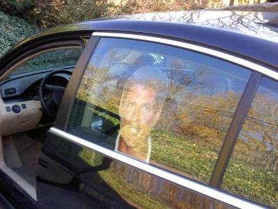
The Hasselhoff head in question. Here it is pictured on the driver's side; I have since moved it to the passenger side because every time Mrs. Monsoon parked to my left in the driveway, she would be startled by the Hoff face staring at her, causing her to utter something like, "Gaaa! God damn it, it's Hasselhoff."I was stopped at the light at 5th and Washington Streets on my way to take The Bunk to day care (don't judge) and then go to work. I had just bade auf wiedersehen to my sweet wife, whose drive to work partially parallels mine.
[I pause here to remind you that my rear passenger side window is adorned with a life-size Hasselhoff head.]
A cab then pulled up alongside me to the right, and the driver rolled down his window, smiling broadly.
"That's the Hoff, huh?"
"You know it!"
"Aw, nice dog, there. [in Bunk's direction:] Mwah!"

"Hahaaauh. Thanks!"
And then he was gone. And my day was made.
So what can we expect from this storm tonight?
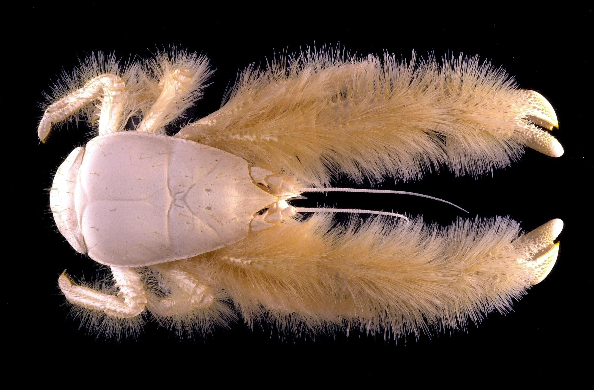
It's the Yeti crab, nicknamed the Hoff Crab by the crew who found it (on account of its evocation of Hasselhoff's hairy chest). It's found in the extreme southern Atlantic. Seriously. The Hoff Crab.Snow and sleet begin by 8 or 9 tonight, continuing and mixing overnight. The extent to which they mix (and the extent to which rain mixes in) depends on your location. In Berks County and points north and east, we're looking at a mostly snow and sleet event. In the immediate suburbs of Philadelphia and points south, it'll be mainly rain. Location will be important with this one.
During tomorrow morning's rush hour it'll still be sleety, but then it mixes with (then changes to) rain, ending by around noon.
Total accumulations of snow and sleet will be in the 1-3 inches range (and likely on the low end of that). Temperatures will hold fairly steady in the low to mid 30s, so we could see some deterioration in travel conditions for the early morning rush.
Probability of delay for Wednesday: 40%
Probability of cancellation for Wednesday: 15%
Stay tuned for updates as they become necessary this evening!
Search queries, CNN, balls-coldness, and January outlook: welcoming 2013!
New Year's revellers!
The end of the year (and a similar exercise on the excellent website Passive-Aggressive Notes) got me thinking about the search queries (on Google, Bing, and other engines) that led people to my weblog. I present some of the most interesting ones here, without comment. (And a special treat, right at the end, from last night's hilariously inappropriate New Year's Eve coverage on CNN.) Please to enjoy:
five guys
many are trapped for hours in darkness and confusion
will it snow on wednesday
eagle’s eye sweaters
rockford files firebird
burger grease paper
unsere freunde book
frere mosoon the wire
blue oyster cult snl
subliminal weed messages
forecastive
frosty pumpkin
hasselhoff berlin wall
monsoon sweatshop
hasselhoff monsoon
hasselhovian
hoffophilia treatment
shakespeare behind bars ksr
armani spade climax
five guys yum
And now, on to the weather.
What to expect in the first two weeks of January…
Tuesday 1/1/13 will be overcast with some afternoon flurries possible. Becoming much colder tonight. High 41, low 22.
Wednesday 1/2 will be, as promised, much colder. In fact, it will set new marks for the season on the balls-coldness meter (apologies to Trevor Wagner for stealing that term). The balls-coldness meter runs as follows:
BC1 = temperatures of 35-40, with wind chills and other atmospheric conditions factored in. (For example, a temperature of 45 with moderate winds would result in wind chills within the BC1 range. A temperature of 36 with no wind would also fall within the BC1 range. Frozen or chilly precipitation can also cause the BC level to drop by a few degrees.)
BC2 = temperatures/conditions/wind chills 25-35.
BC3 = temperatures/conditions/wind chills 15-25.
BC4 = temperatures/conditions/wind chills 0-15.
BC5 = temperatures/conditions/wind chills below zero.
The BC meter does go above BC5, but it's rather self-defeating. Once the temperature sinks under 20 degrees below zero, the testicles instinctively retreat up into the body cavity, rendering the BC scale obsolete. It's science.
So Wednesday will be mostly sunny with moderate winds. Highs below freezing and lows in the upper teens. That places us in the BC3 range.
Thursday will be partly cloudy with light winds, intensifying late. High 35, low 21. (BC2, falling to BC3 in the evening.)
Friday looks sunny and rather windy. High 34, low 21. BC3, falling to BC4 overnight.
Saturday will be similar, but with diminished winds. High 38, low 24. BC1-BC2.
Sunday is the same—in conditions, in temperatures, and in BC levels. So is Monday.
Tuesday 1/8 and Wednesday 1/9 will be a bit milder (highs in the mid 40s) with variable cloudiness and a slight chance of snow/rain. BC1 in the daytime, BC2 at night.
Sunny and windy on Thursday 1/10 with highs in the mid 40s and lows in the mid 20s. (Again, BC1 during the day, BC2 at night.)
Friday 1/11 looks cloudy with some rain showers possible. High 48, low 40. BC1, but BC2 in the evening and in the chilly rain.
Saturday and Sunday will be sunny and chillier. Highs in the upper 30s, lows in the lower 30s. BC1 in the day, BC2 at night.

Monday 1/14 and Tuesday 1/15 look potentially interesting. Temperatures will be in the 30s and some precipitation will be through, so we could see some snow or freezing rain out of this. I will keep an eye on this situation and update you.
Thereafter, it appears that temperatures will rise (highs in the upper 40s), then fall. The second half of January looks to be more precipitation-heavy than the first half of the month. I also expect us to hit BC5 by the end of January, so we have that to look forward to.
Stay tuned for updates, and happy 2013!
Snow Update: overnight freeze?
A week ago, I arrived at school (for an in-service day) to find the stairwell lined with streamers, balloons, and candid shots of me. As I reached the top of the stairs, a row of my colleagues/friends serenaded me by singing "Happy Birthday" whilst wearing David Hasselhoff masks.
These masks--each one, a life-sized head-shot of The Most Hoff fastened to a long wooden skewer--are works of genius. And I decided that I had to incorporate one into my everyday life. So I jammed one into the backseat driver's side window-crevice of my sweet hoopty. See below.

And so it is with this emblem of Hasselhovian magnificence that I make my way about town. And it is just this Hofftastic countenance that I credit with saving my life.
Over the break, I was driving along Perkiomen Avenue when I pulled up at a stoplight behind a car that held a driver and passenger, both of whom appeared to be texting. In fact, the driver's very last concern in the world seemed to be the operation of her vehicle.
It's relevant here to note that these two young women--as I realized later--had a rather rough look about them. They had the kind of hard look that seems to glare out at the world, just daring someone to mess with them.
But again, I didn't realize this until later.
The light turned green, and the car in front of me did not move. A few beats went by, and I sounded an alert with my horn that was intended to be friendly. You know, "Hey there! Hi. Not sure if you had noticed, but the light has changed! Alrighty..." rather than, "Move your ass!"
Apparently, they took it as the latter.
I had overtaken them at some point soon thereafter, and at the next two-lane opportunity, the rode my back bumper hard, then zoomed up alongside me--bent on revenge or mayhem. I think they intended to holler (not holla) at me, or run me off the road, or ram me. Or shoot me. Hoff knows what.
But just then, a funny thing happened: they began laughing merrily, and waved in the most amiable way.
They had seen The Face of The Hoff, and it had tamed them.
So it snowed most of the day, and if I had a nickel for every time a student asked me if we were going to get out early, I'd have my very own authentic K.I.T.T.
We got about what I thought - an inch or two in Berks. Graterford and Skippack picked up a bit over three inches. Elverson and some places in the Poconos were "sweet spots" with four and a half inches. Roads were a bit treacherous this morning--particularly secondary roads, which quickly became snow-covered. Not sure that a delay would have done us any good, and once we were in school, an early dismissal wouldn't have made much sense either.


Yes, this is David Hasselhoff dressed as Captain Hook, atop K.I.T.T. And yes, that is David Hasselhoff in the poster over his own right shoulder, photobombing himself. And yes, if you look closely, you can see the photographer in the glare on the hood--all of which makes this photo the perfect example of Hasselicious meta-promotion.Temperatures are expected to get well below freezing tonight (into the mid 20s around here), so the slushy wetness on the roads can freeze into black ice. This slipperyness may persist into early tomorrow morning, but by the time most of us are making our way to work, the sun should dry things out. As a result, I'm only predicting a 20% chance of delay on Wednesday 11/28.
Wednesday turns out mostly sunny but breezy and cold, with a high only in the upper 30s.
Becoming milder toward the weekend - Friday will get into the 40s; Saturday and Sunday will see highs into the mid 50s. Rain is possible on Sunday, and as well through much of new week.
Next really good chance of frozen precipitation for us in December 11th-12th, but that's two weeks away, so let's just relax.