
Monsoon Martin's "Open MRI," My Fifth Vertebra Forecast
Weather-friends,
First, I want to say regarding Sunday night into Monday that there is still the potential for snowfall and the slight chance it could accumulate, but I’m leaning heavily toward a storm track that will miss us altogether, bringing only snow and rain showers to our area during that time. I will post an update in this space if the situation changes dramatically over the weekend.
Second, I’d like to submit “Open MRI” to the pantheon of particularly cruel or egregious oxymorons, or contradictions in terms, of which some of the most famous and appropriate are “jumbo shrimp,” “open secret,” “peacekeeper missile,” and “military intelligence.”
Why? Because yesterday, I became the victim of a medical bait-and-switch of the cruelest sort. I was sent for an MRI by my doctor to take a look at my lower back, which as many of you know has been hobbling me for some weeks now. Knowing of my claustrophobic tendencies, not to mention my … generously apportioned physical stature, my doc sent me to Ephrata Open MRI. Open MRI, I thought. Sweet. In a regular MRI, in case you’ve never had the pleasure, the patient is loaded onto a slab and shoehorned into a massive structure like a round peg in a square hole—where the patient must stay, unmoving and unable to move any part of the body, for up to an hour. (I had an MRI way back in high school when I was getting severe migraines but was somehow not all that affected by it then.)
An Open MRI, I imagined, would be an absolute dream. There would be no shoving my immobilized self into a space no bigger than a morgue drawer. Surely in an Open MRI I would be free to move about gaily as I wished. I would be forced to sit (or perhaps lie) still for a short, pleasant enough period, during which time some sort of machine would take some sort of picture of my lower back. It would all be over in mercifully brief fashion, and I would experience none of the claustrophobia associated with the typical MRI experience.
My people, what followed instead at Ephrata Open MRI was 50 minutes of meta-claustrophobic torment. (For those of you who are new to the Monsoon weather list and/or weblog, it should be noted that my accounts of personal turmoil and inconvenience are not without their liberal pepperings of hyperbole and histrionics. I admit this now, only in a moment of weakness, and will never do so again.)
I was told to “gown up” and led into the MRI room by a technician who was, to her credit, extremely patient and understanding. I was laid on a table, facing feet first into a gargantuan, ringed structure that resembled a sort of brick oven (like at Carrabba’s in Lancaster, which is totally good) but instead of creating scrumptious northern Italian cuisine, it created only vise-like pressure and shrieking terror. (I told you: hyperbole.)
The technician (I forgot or blocked her name; let’s call her Hazel) then told me I had an array of music choices to accompany my ordeal. A few radio stations came in fine, she said, though two—94.5 (the evangelical Christian station) and a country music station—came in best. Need it be said here that I declined to listen to either station? She also said she had a few CDs to choose from: Enya, some philharmonic thing, and a Sting CD which she said was called All the Hits. Now, Enya takes me back to the days at Albright when my roommate would play the purportedly soothing—but actually numbingly bland—music of Enya and Yanni (I am dead serious) and make me want to jam hot knives into my earholes. I typically shun classical music as aggressively European and staid; it’s the white man’s music. And I used to be quite a Police fan, and Sting’s early solo work was quite good (the later period, when he was doing guest vox on vapid hip hop tunes, not so much). So yes, I said, let’s crank up the Sting!

Soon my torso was swathed in some sort of heavy wrap and I was then inserted, like a tongue depressor, into the gaping maw of the Open MRI machine, forcing the air out of me like I was a sad Tupperware container. I stared up at the ceiling of the “Open” MRI machine, which was about an inch and a half from my face and ended at about eye level (the top was open, so I could look up, to the side and out, and my feet were hanging out the other end, which mattered not at all, though I suspected contributed to their being able to use the meaningless term “open” in describing the MRI).
I began to wonder if I was going to make it through this—laying there uncomfortably for the better part of an hour, unable to take a full breath, the world closing in on me. Hazel observed that I was getting a little “wigged” and said gently, “This isn’t supposed to be stressful, you know?” to which I responded with a weak chuckle. Hazel handed me a small, rubber ball connected to a wire that looked like the end of a sphygmomanometer (blood pressure taker); I was told to squeeze it if I needed anything. This offered me little solace.
As the machine began its work, a few realities quickly became apparent: first, that my mild claustrophobia had evolved considerably; second, that the machine makes an irregular, intervallic death rattle that sounds like an excavator is operating on top of me, or some sort of undulating Lex Luthor death contraption; and third, that the Sting CD was one of the most wretched collections of aural ineptness ever put to record. The fact is that Sting had dramatically reworked many of his most well-known songs (including “Fragile,” “When We Dance,” and “Fields of Gold”) and performed them in front of an exclusive audience in Tuscany for an album that was actually called All This Time. His arrangements are whitebreadedly affected and ponderous, his delivery sloppy, the instrumentation languorous. The overall effect of listening to this was infuriating: snippets of the work sounded familiar, refrains seemed nearly recognizable, and yet it was all so foreign, so poorly executed…so icky. Sting even—unforgivably—included the (wreckage of the) song “Dienda,” with lyrics inexplicably added, on his CD. “Dienda,” composed by the late Kenny Kirkland and included on Branford Marsalis’ seminal Royal Garden Blues, is an evocative, gorgeous gem—probably my favorite song of all time.

The ensuing 40 minutes or so are a blur of near-panic, existential crisis, and strange, maniacal thoughts. A sampling:
What in the hell is that picture supposed to be?
One, two, three, four, Mary at the kitchen door…
Breathe…breathe…whew…haa…whew…haa…
I’m gonna lose my shit…I’m gonna lose my shit and eject myself out this bitch.
Keep it together keep it together keep it together.
Maybe I’ll try a little visualization…I can visualize my ass right the hell out of here…yeah, I’m not in this machine; I’m in a happy place. A…happy…place. Where’s my happy place? Hoff, are you there? OK. Yeah, a real happy place. Oh, this would be good: I’m back in Rhode Island, it’s last Christmas, and I’m walking with my lovely wife on the Cliff Walk. That was a happy time, and it’s a nice, open vista…yep, I’m on the Cliff Walk. No, I’m still here in Ephrata. I can’t visualize a god damned thing. Jeez, maybe I should take up yoga or something.

I wonder how much time is left?
What does MRI stand for? Oh, that’s right: Magnetic Resonance Imaging. I wish it had taken me longer to figure that out. M…R…I. Am, are, I? Oh, holy crap it’s an existential puzzle. Am, are, I? If I am not, how can I be? And if I be not, am not, whither me? What the hell am I saying?
Why, oh why, did Sting sully his songs so?
How much time could really be left? Oh damn, I wonder if it just seems like a half-hour has passed but in reality it’s only been three! Nah, that’s not possible…
They make bombs that can be programmed to fall on a postage stamp but I have to lay my ass here for an hour and wait for this machine to do its work. Isn’t that a fine how-do-you-do?
“The Wire” soundtrack is really good…oh, I know…I’ll think about my favorite songs on it. That’ll get my mind off things…well, the dialogue snippets are great, especially the Snotboogie material and the “Omar comin’!” piece. The songs are a mixed bag… “Ayo” and “My Life Extra” from the B-more hip hop scene are strong, really hypnotic…and it’s nice to see Michael Franti on there…the Solomon Burke song is outstanding, and I like the “Gilded Splinters” song…I even like the Greek song…The Pogues and Tom Waits, not so much. OK, that’s it. What’d it take, two minutes?
How much longer??
Finally I couldn’t resist any longer and squeezed my little rubber doober to summon Hazel. She came in: “Yes?”
“Oh, hi! Liiiiisten…I was just wondering how much more time?”
“You said hi…that’s cute! Most people don't bother saying hello. No, we haven’t got much more time. One more vertebra, so another nine minutes.”
[long exhale] “Whew. Thanks…I needed to hear that.”
[leaving] “You’re welcome…not much longer!”
“Oh…and could you turn off the music? It is so, so horrible.”
[sniggering] “Sure.”
After this, there’s not much to tell. The end of the test went off without a hitch, as I spent the last nine minutes counting. When it ended, I extricated myself from the machine and happily made my way out of the room. I had one final question for Hazel:
“Why would Sting ruin his music like that?”
“I know, right?”
Monsoon
Monsoon Martin's I'm Back! Weather Update
Hey, weather-friends,
It has been several weeks since I have addressed you all, and fortunately it’s been a quiet weather period so you weren’t missing out on vital information or anything. I thought I’d take a few moments to offer you an explanation of my absence, provide a forecast and a new post to boot.
My absence was partially due to a heavy workload (Term Paper grading) and partially due to pain. About the Term Paper grading I have little to say, except that the ordeal will be over for another year when I’ve graded the final drafts later this month. About the pain, which held a vise-like grip on my extreme lower back for a couple of weeks off and on, I will speculate briefly about its cause: slipping on ice at Vision Volkswagen; hunching over miserably grading term papers; and careening colossally off a rolling desk chair prior to the winter holiday. I dare not say more for fear of implicating my abettors and arousing the suspicions of The Man.
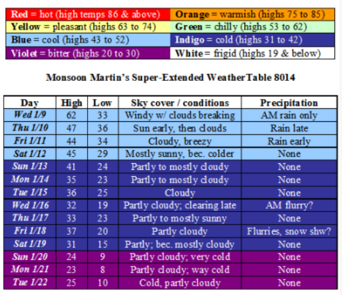
Weather narrative: First, I want to announce a small change to the WeatherTable: I have eliminated the wind speed column and will only remark on wind when it is notably strong or pungent. The unseasonably warm weather, with highs reaching well into the 60s, is coming to an end, but temperatures aren’t going to plunge below normal for another week or so.
I don’t see any really compelling winter weather potentialities on the horizon here. Perhaps toward the end of the forecast period (the 21st, 22nd) we may see a moderate snowstorm. Stay tuned.
Monsoon
Monsoon Martin’s Forecast Update: Vanilla Thunder or Mixed Bag?
Monsoon Martin’s Forecast Update: Vanilla Thunder or Mixed Bag?
Friday, 14 December 2007
First, a comment on yesterday’s storm: we ended up with a quickly-called early dismissal yesterday (my school at 9:30), which may or may not have been necessary—but was surely appreciated and well enjoyed. Slightly warmer surface temperatures caused much of the precipitation to be liquid with ice mixed in, rather than the snow and ice with rain mixed in that I’d expected. Around my parts, northern Lancaster County, we saw rain turn to sleet and freezing rain, then to rain, and back to ice for a bit before tapering and ending by five in the evening. I did not experience any slipping on the roads, though I had slowed it down a bit for most of my commute home. Did any of you have problems with icy conditions, power outages, slip-and-falls, etc.? Let me know by posting a comment at the end of this entry.
And now to discuss the next system, Saturday to Sunday…
This is still a challenging forecast because there are some competing low pressure systems and the wildcard factor of warm air infusing into the mix on Saturday overnight complicating matters. I think what we have to remember (and what we saw in action yesterday) is that it’s still autumn and conditions aren’t quite right for a major, snow-bombing, Vanilla Thunder, foot-plus Nor’easter; these are far more common in February or March, for a variety of reasons.
Here’s my thinking as of today, with the understanding that a shift in the track of a low pressure system of even 25 miles one way or the other could alter it dramatically. (But I’m not waffling: what appears below is what I really think is going to happen.)
Saturday begins clear, cold and dry with temperatures in the upper 20s. Clouds will increase in the afternoon as temperatures rise only to about 34. Look for snow showers beginning by 7 or 8, scattered and flurrying at first. Sleet will begin to mix in by 9 or 10; precipitation will change over to sleet and then freezing rain (perhaps even plain old rain in Lancaster and southern Berks Counties) overnight. We’ll actually sleep through the “heart” of this storm, and a lot of precipitation will fall between Saturday night and early Sunday morning. Winds will increase to 20mph by Sunday morning, and 30 by Sunday afternoon—with gusts above 40.
By the middle of Sunday morning, the system will begin to pull away. Expect rain and freezing rain showers to late Sunday morning. Precipitation will taper on Sunday afternoon, changing to snow and ending by 3pm or so.
Predicted snow totals:
- Greater Reading and southern Berks County: 2-4 inches of snow and sleet accumulation with moderate icing, particularly overnight and Sunday morning; perhaps another inch of accumulation during “wraparound” snow period on Sunday afternoon
- Montgomery and Chester Counties, Philadelphia, South Jersey: mainly sleet to rain south and east; a coating of accumulation at most with little driving hazard.
- Poconos: 12-15 inches of mostly snow.
- North of Reading, Schuylkill County, Carbon County: 4-8 inches of snow and sleet with significant icing; perhaps another inch or two of accumulation during “wraparound” snow period on Sunday afternoon.
-
Lancaster, Lebanon and York Counties: brief periods of snow followed by freezing rain and rain, accumulating to an inch or two of slushy mess at most.
Worst driving times (confining my analysis to the Berks and Lancaster County region):
- Saturday night from 10pm to Sunday morning 10am, I would say you want to avoid being out and about; it will be icy and increasingly windy, with wind chills in the teens.
-
There may be a few brief periods of reduced visibility on Saturday evening and Sunday afternoon during steadier snow showers, but I think one could safely drive with caution at these times.
I do not believe we are likely to have delays or cancellations on Monday at Mifflin or Muhlenberg; perhaps delays in outlying districts like Hamburg and Blue Mountain.
Beyond all this, high pressure builds in. We’ll see sunny and dry but very cold conditions, with highs in the low 30s and lows in the teens and low 20s throughout first half of the week. By the weekend, temperatures will moderate a bit, but I’m now tracking a potential system for Sunday the 23rd. Very cold for Christmas Eve and Day (but no snow, it doesn’t seem), but Thursday the 27th into Friday the 28th may hold more snowfall…
Have a great (and safe) weekend!
Monsoon
Thursday morning update...
Thursday AM update…
Temperatures are a little higher this morning than I thought they might be (showing what a vast difference a couple degrees either way can make). My thinking now is this:
Precipitation will begin as snow by around 8am, mixing with sleet and freezing rain by late morning. The period of most intense precipitation will likely be 11am through 2pm, and sleet will mix in liberally during that time. This will decrease snow totals to 1-3 inches at most (good for me, and all shovelers), but it will also make travel all the more hazardous beginning around 11 and continuing through the evening.
Adjusted predictions:
Early dismissal Thursday: 85% (faculty meeting, postponed)
Cancellation Friday: 15%
Delay Friday: 60%
Disclaimer: Please remember that these are predictions by Monsoon, and despite being employed by GMSD, I have no control over these decisions!
Stay tuned for further updates…
G.
Quick update from Monsoon on the Thursday event
Weather Update from Monsoon for Wednesday, 12 December 2007
Weather update from Monsoon for Wednesday, 12 December 2007…
Weds 12/12 cloudy and quite foggy with morning showers and a slight chance of afternoon showers. Temps beginning near or just above 50 after rising overnight, then falling through the 40s in afternoon and evening, finally arriving at a low around 30. Moderate to strong winds becoming light.
Thu 12/13 colder with scattered freezing rain and sleet in the morning, beginning perhaps by mid to late morning; a bit of snow may even mix in from Reading northward. A messy mixture will persist throughout the day with mostly frozen precipitation before noon, then rain with a bit of frozen mixed in for the afternoon, then from 5pm onward frozen precipitation (mostly snow) predominates again. Precipitation (in whatever form) will become steadier and heavier throughout the afternoon and evening, tapering late.
Chance of delay: 10%. Chance of cancellation: 15%. Chance of early dismissal: 55%. High 33, low 29.
Accumulations depend greatly on storm track and temperature fluctuations, which are up in the air right now (no pun intended). My best guess right now is that areas in Reading northward will have 4 inches of accumulated snow by late Thursday night, with some sleet and freezing rain mixed in to make things messy. South of Reading and into Lancaster may have a bit more of the freezing rain and sleet, less of the snow.
Fri 12/14 clearing considerably and somewhat milder. High 41, low 22.
Chance of cancellation: 20%. Chance of delay: 60%.
Sat 12/15 there’s the potential for a “doozy” of a Nor’easter on Saturday into Sunday. Right now so much could change—storm track, air temperature, water temperature, and other factors could throw a mighty monkey wrench into this thing, pulling it off-course or making it all or mostly rain for our area. Right now, though, it looks as though rain begins early Saturday afternoon, changing to snow by evening and continuing, heavy at times, through Sunday afternoon. It should be quite windy, too, so snow-sagged power lines and falling limbs could be an issue. Forecast models (and some of my own digging) suggest this could be a significant Nor’easter with snow totals reaching double digits. Again, there’s no reason to get your draws in a tangle over this yet, but it’s something I’m watching with more than a little interest. High 33, low 22.
Sun 12/16 as stated above, snow could persist into Sunday afternoon, giving way to a mostly cloudy night of shoveling. High 37, low 23.
Mon 12/17 these numbers will, of course, be updated on Friday as things fall into clearer focus. Partly cloudy, windy and very cold. High 31, low 18.
Chance of cancellation: 60% (if the storm hits); chance of delay: 75%.
Tue 12/18 sunny and very cold. High 28, low 14.
Wed 12/19 cloudy with snow developing late. High 29, low 21.
Thu 12/20 cloudy with periods of snow and sleet giving way to rain in the afternoon. This is another one to watch; could be hazardous. High 38, low 24.
Fri 12/21 partly cloudy and milder. High 41, low 29.
Next weekend cool Saturday with a chance of rain, freezing on surfaces at times. High 35, low 26. Sunday will clear up; sunny conditions will prevail. High 37, low 29.
Beyond temperatures adjust to about normal for this time of year—highs in the upper 30s and low 40s; lows in the upper 20s to low 30s. Right now it’s not looking like it’s going to be “White Christmas” (unless we get this storm on the 15th and another potential storm on the 20th, and the snow ground cover from these lingers).
Monsoon
Monsoon's afternoon update
Hey folks...
Yes, I was wrong. Not calamitously wrong or egregiously wrong, but wrong enough that there are big snowflakes falling from the sky when I said there'd be rain. What happened? The temperature stayed low, and the system was more organized than I thought it would be.
So here's the story: The snow will taper off beginning around 3:15 and be gone by 3:30 or 3:45. A total accumulation of a half-inch (which was in my original prediction) up to an inch will result. Some of youse may see slippery conditions, especially on ramps and overpasses, during the evening commute--but over all I think road conditions should just be wet and not compromised to any alarming extent.
Have a great weekend and drive safely!
Monsoon
Monsoon's Update for Friday the 7th
My friends…
I am in the midst of grading Term Paper outlines and reading gems like “Back in the day, African Americans and women had rough lifestyles. Celie is both an African American and a women” and later in the same paper, an observation that Celie is “physically and mentally messed up” by her experiences. It is at these times of year—Term Paper grading, in particular—when we question not only whether we are doing any good at all as teachers, but whether we can go on at all.
And so I offer you just a simple forecast that includes the potential for precipitation every day from today through Tuesday—but nothing during that period that will accumulate impressively or threaten our work or shopping schedules.
Friday 12/7: Cloudy with snow flurries and showers this morning, accumulating a half-inch at most, then changing over to rain showers at or around noon. Rain tapers by late afternoon. High 35, low 27.
Saturday 12/8: AM clouds with a flurry possible, then clearing toward afternoon. A bit warmer. Moderate WNW winds. High 41, low 23.
Sunday 12/9: Cloudy and rainy, especially in the afternoon. Temperatures should stay above freezing, so this should be rain (rather than sleet and snow, or even freezing rain). Showers should taper late, but chance of precipitation stays with us overnight. High 40, low 33.
Monday 12/10: Mostly cloudy with a few showers likely late; if the temperature drops, these could be brief snow showers with little or no accumulation. High 38, low 33.
Tuesday 12/11: Cloudy and warmer with rain likely. High 48, low 37.
Wednesday 12/12: Cloudy to partly cloudy and still unseasonably mild. Moderate to strong WNW winds. High 45, low 26.
Thursday 12/13: Partly cloudy and cooler. High 38, low 24.
Friday 12/14: Partly cloudy. High 36, low 19.
Next weekend: Cold with plenty of clouds around. Highs in the mid 30s; lows in the teens to low 20s.
Beyond: Cold with frozen/wintry precipitation possible around Tuesday the 18th and Thursday the 20th.
Take care,
Monsoon