
Monsoon's Weather Update for Thursday, 4 September 2008
Thursday will be sunny, clear, quite hot again, and a bit humid, with a high of 92 and a low in the mid 60s.
Friday will be partly sunny and warm with humidity—and clouds—increasing throughout the day. The rain and wind from Tropical Storm Hanna (downgraded by that point from hurricane status) are expected to arrive in the evening—look for the first drizzle and showers by 9 or 10pm into the overnight hours. Thunderstorms can mix in here as well. High 87, low 68.
Saturday will see the heaviest rain and winds (and maybe a few storms) from Hanna in our area. Look for intermittent rain punctuated with periods of intense, heavy rainfall. Winds will be blowing at up to 25 mph (sustained) with gusts possible in the 35-40 mph range. Rainfall totals for Saturday alone will range from three quarters of an inch to two and a half inches across the region, depending on the area. Toward Saturday evening, the precipitation starts to pull away. High 77, low 65.
On Sunday we’ll see significant clearing; aside from a stray shower or two possible very early Sunday morning, we should be drying out. Look for partly sunny, breezy, and milder conditions with a high of 84 and a low of 60.
Monday looks great: sunny to partly cloudy with a high of 78 and a low of 56.
A shower is possible on Tuesday, but otherwise the day looks partly cloudy and pleasant with a high of 76 and a low of 55.
The rest of next week is looking lovely: sunny and clear with highs in the mid 70s and lows in the low to mid 50s.
Next weekend is a mixed bag: Saturday the 13th looks OK, if a bit chilly (highs only in the upper 60s and overcast), but Sunday the 14th will be rainy and cool, it appears at this point.
Thereafter: pleasant and mild with highs in the mid 70s and lows in the mid to upper 50s.
Monsoon's Weather Forecast for Saturday, 30 August 2008
Friends…
An updated forecast and WeatherTable…
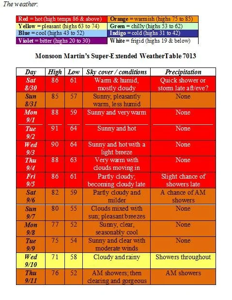
Weather narrative : Today (Saturday) we could see a quick pop-up line of showers or thunderstorms, but I think most places are going to be dry and rumble-free. After today, the next best chance we have of seeing any rainfall is actually the following weekend, Friday into Saturday. The lack of rainfall we’ve had lately is a trend that looks likely to continue, which could lead to drought warnings (currently Berks is in “normal” status, while Lancaster, Lebanon, and Schuylkill Counties are under a “watch”).
Monday through Thursday (the first four days of September) will feel more like the Dog Days of August that never really materialized this year, with highs in the upper 80s to low 90s. (At least the humidity will stay relatively low—sorry for the pun.)
Perhaps a bit of rain as a cold front moves through around the beginning of next weekend and returns us to more pleasant conditions: highs at or just below 80, with lows in the 50s.
Beyond the forecast: Pleasant with highs in the mid to upper 70s and lows in the mid 50s.
Happy Labor Day!
Monsoon's Weather Update for Friday, 22 August 2008
Friends…
An updated forecast and WeatherTable…
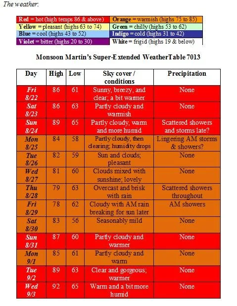
Weather narrative : Tropical Storm Fay has made a left-hand turn into the Gulf of Mexico and will not affect our weather here.
The humidity rises a bit this weekend, but some showers and storms late Sunday into Monday will disperse the heat and humidity, ushering in a pleasant week.
Not a lot of rain is in our forecast—just scattered showers here and there as noted.
Next weekend (Labor Day) is looking fantastic aside from some rain Friday.
Beyond the forecast: After perhaps reaching 90 degrees in the first few days of September, the temperature will drop precipitously, with highs getting only into the mid 70s and lows dipping well into the 50s.
Monsoon's Weather Update for Sunday, 17 August 2008
Friends…
A weather update for y’all as we prepare for the start of another school year…
(On a personal note, it is nice to begin a school year without having to worry about sweating through my clothing for the first month and a half of school. Thanks to our glorious new air conditioning system, my students will be shivering unhappily and I will be in blissful comfort.)
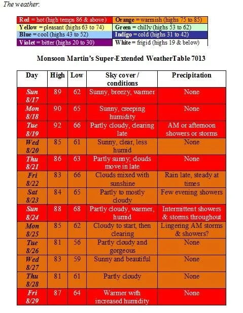
Weather narrative : Aside from some moderate heat and humidity to begin the coming week, the forecast period is pretty much steady with highs settling around the mid 80s and lows in the low 60s. Look for the possibility of rain from Friday night into Sunday morning as the remnants of Tropical Storm Fay (which should be significantly weakened by the time it reaches us due to the fact that it’s traveled so far over land, but still may carry pockets of heavier rain and strong winds) move through.
Next week looks very nice with highs in the low 80s and lows in the upper 50s for the most part. Warming up by the end of the week and (as it appears now) ushering in a miserable, rainy Labor Day Weekend.
Beyond the forecast: Labor Day Weekend is looking cooler and rainy with highs in the 70s, lows in the 50s, and rain possible on both Saturday and Sunday; Monday, September 1st is looking very nice. But hey…a lot can happen between now and then! I will keep you posted…
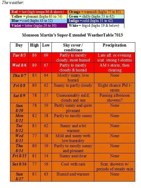
A Forecast Update From Monsoon
Tuesday 8/12: Partly sunny, breezy, pleasant and a bit warmer than the previous couple of days, but still unseasonably mild. High 80, low 61.
Wednesday 8/13: Sun mixed with clouds and warmer. Slight chance of a passing shower or thunderstorm, especially in the early evening. High 86, low 64.
Thursday 8/14: Partly sunny; becoming cloudy with a shower or two around in the evening. High 81, low 62.
Friday 8/15: Mostly sunny and pleasant. High 79, low 58.
Saturday 8/16: Partly sunny with the slight chance of a shower late. High 82, low 61.
Sunday 8/17: Partly to mostly cloudy with a few passing showers possible in the afternoon or evening; warmer and somewhat more humid. High 86, low 63.
Monday 8/18: Mostly sunny and warmish. High 84, low 63.
Tuesday 8/19: Cloudy and humid with showers and thunderstorms likely. High 80, low 68.
Wednesday 8/20: Partly cloudy, warm and humid. High 87, low 64.
Thursday 8/21: Partly to mostly sunny. High 90, low 66.
Friday 8/22: Hot and humid with hazy sunshine. High 93, low 67.
Next weekend: A return to unseasonable mildness; on Sunday, the high will not even make it out of the 70s.
Beyond: Clear and gorgeous for the first day of school (8/25). High of 74, low 57. After that, we’re looking at another little blast of heat and humidity, but nothing approaching even the mid to upper 90s.
Monsoon's Weather Update for Tuesday, 5 August 2008
Hey again, friends…
Here’s my first official forecast in a little while. A reminder that my predictions are focused on the weather in and around Shillington, PA (where I teach) and that generally minor fluctuations should be expected in surrounding areas.
We have a gorgeous and unseasonably mild stretch in front of us here: low humidity, moderate temperatures, and clear skies dominate the extended forecast.
Weather narrative : Thunderstorms moving across the Midwest will arrive in our area later this evening and overnight. The storms currently affecting parts of Illinois, Indiana, and Ohio are quite violent, but by the time they reach us, they’ll be rather weakened. Still, look for strong winds and heavy rain with some of these storms. On Wednesday, we’ll start with high humidity and a few stray showers or storms, but then we’ll see clear and lowering dewpoints.
For the most part, through the end of this week and into next week we’ll see temperatures and humidity levels more typical for June or September than August. This time of year, highs average in the 85-87 degree range with lows in the mid 60s and high humidity.
After tomorrow, our next really solid chance for rain looks to be Saturday, August 16th.
Beyond the forecast: Believe it or not, the trend is actually for more mild weather, with highs the following week in the mid 70s and lows getting into the low to mid 50s! (Of course, all that can change, but that’s the way it looks to me now…)
Monsoon's Weather Update for Thursday, 5 June 2008
My friends,
I’ve decided to try something a bit new for this forecast: I’ve included a WeatherTable and a standard, day-by-day weather narrative. You’ll enjoy the coming week or so if you like things hot and sticky…
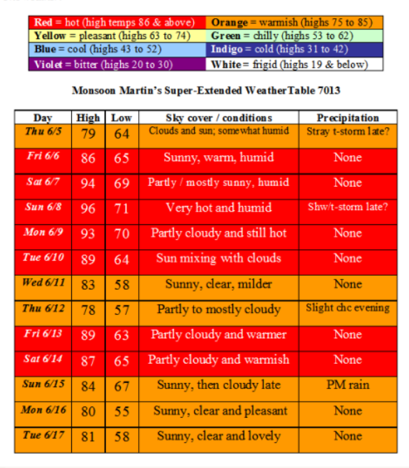
Thu 6/5 - Mainly cloudy with some breaks of sunshine. Temperatures will be fairly moderate, but humidity will make it feel a bit warmer than it is. Look for a stray thunderstorm or two late in the afternoon. High 79, low 64.
Fri 6/6 - Plenty of sunshine, somewhat warm and quite humid. High 86, low 65.
Sat 6/7 - Partly to mostly sunny, hot and humid. High 94, low 69.
Sun 6/8 - Partly cloudy and continued very humid with near-record heat; look for a shower or thunderstorm in the late afternoon or early evening. High 96, low 71.
Mon 6/9 - Partly cloudy and hot with humidity dropping a bit, but the heat wave continues. High 93, low 70.
Tue 6/10 - Sun mixing with clouds. High 89, low 64.
Wed 6/11 - Sunny and clear; moderating temperatures. High 83, low 58.
Thu 6/12 - Partly to mostly cloudy with a slight chance of rain in the evening. High 78, low 57.
Fri 6/13 - Partly cloudy and warmer. High 89, low 63.
Sat 6/14 - Partly sunny and warmish. High 87, low 65.
Sun 6/15 - Sunny to begin with, then turning cloudy and rainy late. High 84, low 67.
Mon 6/16 - Sunny, clear, and pleasant. High 80, low 55.
Tue 6/17 - Sunny, clear, and lovely. High 81, low 58.
Beyond - Weather will be more appropriate for mid-June: highs in the mid 70s to near 80; lows in the upper 50s to low 60s. By the end of June, look for the season’s next heat wave (a prolonged period of excessively hot and abnormally humid days; the guidelines for usage of this term vary, but typically we look for heat indices above 90 for at least three consecutive days).
Monsoon's Weather Update for Wednesday, 28 May 2008
The end is mercifully in sight, and here’s a weather update, my friends, to get you thinking about your summer plans…enjoy!
The weather :
Weather narrative: Tonight will be the chilliest night in the foreseeable future with lows dipping into the mid 40s. By week’s end, temperatures warm into perhaps the low 80s with some spikes in humidity. Right now both Mifflin’s graduation (6/2) and Muhlenberg’s (6/4) look rain-free, with the latter potentially warmer. (Both are indoors at the Sovereign Center, I’m just thinking about conditions coming and going.)
Pleasant conditions will persist into the following weekend, which will usher in very warm temperatures reaching into the upper 80s and perhaps even hitting 90 sometime around 6/8 or 6/9.
Beyond the forecast: A cold front comes through right around the 10th, cooling high temperatures into the low 70s and dropping plenty of rain.