
Monsoon's Wet Weather Update for Wednesday, 10 December 2008
Wednesday will begin in the upper 50s to near 60 with all rain—and quite a bit (up to an inch in some places) after a drizzly early morning. Rain tapers in the evening, but clouds stick around as another round of rain will ride along the frontal boundary on Thursday. Windy. Temperatures dropping throughout the day to the upper 30s overnight.
Thursday late morning into Thursday night, another round comes in (may linger to Friday morning) which looks to bring heavier rain. I think it’s all rain with some sleet/freezing rain on the tail end for our area.
Let me talk about that “tail end”: this is the tricky part. If the colder air dips in underneath the warmer air aloft (the air that’s helping to moderate temperatures on Wednesday), and it happens a bit earlier than expected, we could a sleet/rain mix by rush hour Thursday and a few inches of accumulating snow throughout the evening and overnight before it tapers off. But I think the milder air will win out where and when it counts, so that the precipitation for our area will be nearly all rain with some sleet and freezing rain mixing in at the tail end.
For Philadelphia and the surrounding counties, there will be little or no “tail end”; that is to say, it’s an all rain event, so no worries about deteriorating driving conditions on Thursday night.
Another inch or two of rain in this second “wave” makes 3+ in some places for both waves of rainfall. Breezy and colder Thursday with highs only getting into the upper 30s and dropping at night through the 30s to below freezing. A few flurries or snow showers overnight and into early Friday morning may deliver a coating to an inch.
Friday is very cold with a high only in the mid 30s and low in the low 20s—perhaps the teens.
Delays/cancellations: Wednesday, no chance. Thursday, no delay or cancellation, but 10% early dismissal. Friday, 65% delay; 30% chance of cancellation.
Looking ahead: next week’s Wednesday-Thursday storm is setting up nicely, but high temperatures will be into the 40s for the week, so it’s looking like rain right now. But it’s still early.
I’ll send out an update tomorrow (Thursday) if anything changes...
Monsoon's Update for Sunday, 7 December 2008
It's always a good day when the Eagles beat the Giants, and the Cowboys are handed an ugly loss--all within the span of a few hours. The only thing better will be when the Eagles whup Dallas at the Linc on December 28th...
Mrs. Monsoon and I saw a great fight card at the Sovereign Center on Friday night, which featured impressive knockouts by Philly's Mike Jones (pictured below) and Reading's Jason Cintron (younger brother of welterweight star Kermit, who was ringside to cheer on his sib). Inexplicably, the card--staged by Golden Boy Promotions and televised by the Spanish-language outlet Telefutura--was sparsely attended by fewer than 1,000 fans. I would have thought that world-class professional boxing would draw more spectators...

Anywho, on to the weather, which is sumbitching cold. An update:
Very, very cold Monday with overnight/morning lows in the mid teens and an afternoon high of only 31.Winds diminishing.Chance of delay Monday: 20%.
Becoming milder overnight Monday into Tuesday, so precipitation will be largely rain; snow showers with negligible accumulation may mix in early.High 43, low 38.No delays or cancellations.
After rain and drizzle overnight, expect still milder conditions on Wednesday: it will be cloudy with a warm breeze and some rain showers and drizzle; thunderstorms may even mix in!No delays or cancellations.High will reach 57; temperatures will then plunge to 30 overnight, when we may see some quick snow showers or flurries.
Thursday will be much, much colder with a high only reaching about 32 and a low of 18.I’m keeping an eye on a storm that has the potential to bring us a few inches of snow on Thursday.Chance of cancellation: 45%; chance of delay: 60%.
Friday looks clearer and very cold.High 33, low 18.Depending on what we get Thursday, we could be in for a delay on Friday.
The weekend will be seasonably cold with the slight chance of snow showers on Saturday evening.Highs in the mid to upper 30s; lows in the mid to upper 20s.
Next week will begin in much the same way, with seasonably cold temperatures.After a period of rain on Monday evening, we may see a bit of accumulating snow on Tuesday and Tuesday night—giving us a chance of delay or cancellation for Tuesday.The most intriguing event comes in Wednesday into Thursday, when we could get snow mixed with dangerous sleet and/or freezing rain.
Next weekend is now looking rainy and warmer over all, with highs in the upper 40s to low 50s.
Beyond will be colder, but nothing approaching the frigid conditions we’re experiencing now until the second week of January or so.As of now, it’s not looking like it’ll be a “white Christmas.”
Stay tuned for updates...
Monsoon's Complete Weather Update for Friday, 5 December 2008
Habari mori,
Here’s the forecast, which includes some very chilly weather, several chances for frozen precipitation, and a few potential delays or cancellations.Just a quick reminder that anything beyond a few days is subject to change dramatically depending on a variety of factors.I will send updates as needed to clarify and provide more specifics.
The weather:
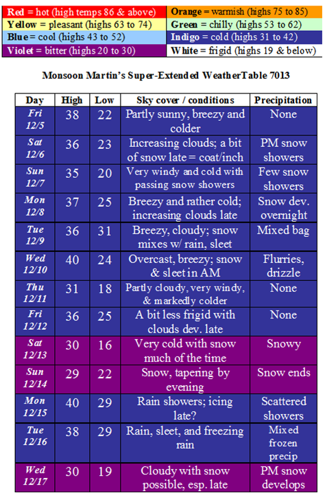
Weather narrative: Cold air is entrenched in the region now, and a clipper system moves through over the weekend, as noted.These are notoriously difficult to predict; often they fall apart and produce only widely scattered snow showers, but there is evidence that this time it’ll hold together a little more nicely and give us a coating to an inch—maybe a couple of inches in some places.Another system will bring snow overnight Monday the 8th into Tuesday the 9th.Right now Tuesday looks to be a “mixed bag” with potentially hazardous conditions created by snow and sleet.
Next weekend looks like it may bring us some steadier snow that could accumulate in the 4-6 inch range.We get a brief warm-up to begin the last full week before break, and then another system could produce snow and some schedule problems as well around the 17th and 18th.
Future weather: After the 17th-18th weather system, things begin to moderate a bit for the remainder of the month.
Delay & cancellation potentials:
Monday 12/8 delay, 60%; cancellation, 20%
Tuesday 12/9 delay, 30%; cancellation, 65%
Wednesday 12/10 delay, 25%; cancellation, 10%
Wednesday 12/17 delay, 70%; cancellation, 25%
Thursday 12/18 delay, 55%; cancellation, 75%
The Official Monsoon Martin Winter 2008-09 Outlook
‘Sup,
Before I reveal my first annual Official Monsoon Martin Winter Outlook, I want to welcome a new member to the Martin family.His name is Bunk, he’s a three-month-old standard poodle, and he’s a bearish bundle of furry sweetness; the sound of his inquisitive paddling around the kitchen sounds like a five-year-old in footy pajamas skimming happily across the floor, and makes us very happy.Of course he cannot replace Sasha and Ruthie, whom we lost earlier this month and miss desperately.Thanks again to those of you who offered your kind condolences on their passing.
But Bunk can help fill the void left in our lives by the absence of our late companions, and recover some of the peculiar joy we derive from welcoming an animal into our home.I look forward to keeping you posted on his growth (he’s 25 pounds or so now; he’ll grow to at least 60 pounds) and shenanigans.

Now, for the Official Monsoon Martin Winter 2008-09 Outlook, which is based on my own study of forecast models and meteorological trends, with a generous helping of “gut feeling” thrown in.I’ve divided the winter weather season into seven periods beginning with the first half of December and ending halfway through March (roughly, meteorological winter).Each entry begins with normal temperature ranges, followed by temperature and snowfall predictions, along with accumulation totals and winter weather cancellations and delays for area schools.
Please note that my outlook applies to the region encompassing a roughly 20-mile radius round Adamstown, bounded by northern Berks County to the north; Pottstown and western Montgomery County to the east; Mt. Gretna and eastern Lebanon County to the west; and Paradise and central-southern Lancaster County to the south.
Speaking of the weather, I wanted to share my favorite recent weather-related quote.It was uttered by Danny McBride, who plays Cody, a mulleted pyrotechnics expert in the film Tropic Thunder, when he blows up a row of palm trees: “Mother Nature just pissed her pantsuit!”[A note about Tropic Thunder: I love the film, especially Robert Downey Jr.’s performance in it—he does his best work since his role as Ian in 1985’s Weird Science and as Derek in 1986’s Back to School—but I realize it’s not for everyone.I found its gleeful disregard of propriety intoxicating and Downey’s “400 years” speech made me laugh as hard as anything I’ve ever seen in the movies.]McBride’s phrasing is something I plan to use liberally this winter in endeavoring to explain meteorological anomalies that may arise...
Where was I?Oh, yes.Kind of a lot going on lately.I’ve had a bit of trouble focusing.Back to the Official Monsoon Martin Winter 2008-09 Outlook.There are few really useful climatological clues this season—such as the presence of El Nino or La Niña, neither of which is present in the Pacific this year—so it’s especially difficult to make predictions with any accuracy (particularly regarding precipitation) until just days before the event.But I’m not in the business of equivocation or excuse-making here; I’m about rockin’ this outlook, and rockin’ it hard.Here goes...
First half of December: Average highs are typically in the low to mid 40s, lows in the upper 20s to low 30s.
December 1st to 15th will be colder than normal over all, with some nasty wind chills dipping into the teens.I’m fairly confident we’ll see a snow event in the 4-6” range somewhere around the 9th or 10th of the month; temperatures will become a bit milder then toward mid-month.
Winter weather cancellations and delays: Most of us have 10 school days in this period.I’m predicting 1 cancellation and 1 delay.
Second half of December: Average highs are typically in the upper 30s to low 40s, lows in the low to mid 20s.
December 16th to 31st will be average to a bit warmer than normal, and I do not believe we’ll see a “white Christmas” this year.
Winter weather cancellations and delays: Most of us have only 4 to 6 school days in this period.I’m predicting no winter weather-related cancellations or delays.
First half of January: Average highs are typically in the mid to upper 30s, lows in the low 20s.
After a relatively mild start, the bitter cold sets in by around the second week of January.I’m looking for a small to moderate event in the range of 4-6” early on.
Winter weather cancellations and delays: Most of us have 10 school days in this period.I’m predicting 1 cancellation and 2 delays, mainly due to icing problems.
Second half of January: Average highs are typically in the mid to upper 30s, lows in the low 20s.
Colder to begin the second half of the month, with a significant storm in the range of 10-12”, then a “thaw” with milder temperatures to end the month.Winter’s not over yet, though...
Winter weather cancellations and delays: Most of us have 9 school days in this period.I’m predicting 1 cancellation and no delays.
First half of February: Average highs are typically in the upper 30s to low 40s, lows in the low to mid 20s.
We’ll see very cold conditions and a one-two punch of winter weather events: a fairly moderate storm (6-8”) followed by a big snow (in the range of 12-15”) by mid-month, right around Valentine’s Day.
Winter weather cancellations and delays: Most of us have 9 school days in this period.I’m predicting 1 cancellation and 2 delays.
Second half of February: Average highs are typically in the low to mid 40s, lows in the low to mid 20s.
Around average, with a few days of milder “thaw” temperatures: winter’s chill begins to recede and the snow begins to melt, but a couple of freezing rain/sleet/snow events will make travel treacherous and disrupt schedules in the region.
Winter weather cancellations and delays: Most of us have 9 school days in this period.I’m predicting no cancellations and 2 delays.
First half of March (through the Ides): Average highs are typically in the mid to upper 40s, lows in the upper 20s to low 30s.
I’m looking for near-average temperatures with a few colder days mixed in.If these colder days coincide with a Nor’easter, we could see a major storm develop in the first or second week of the month; I don’t think the pattern is set up for this right now, though.
Winter weather cancellations and delays: Most of us have 10 school days in this period.I’m predicting no winter weather-related cancellations or delays.
Totals and summary: I’m predicting a very active (and frequently, quite cold) winter, especially when compared with the previous 3 or 4 winters, which featured a dearth of snowfall and milder temperatures than normal over all.Snowfall totals will be in the range of 36-42” generally, with fluctuations within the forecast region I outlined above.
Totting up the winter weather-related cancellations and delays: I think we’ll have 4 cancellations and 7 delays.Hell, we may even have an early dismissal or two, particularly in the active period from mid-January through mid-February.
Mother Nature will most definitely be shitting her wetsuit.Or was it sweating through her pantyhose?Puking in her soup?Ahh yes: pissing in her pantsuit.I’ll get it straight...
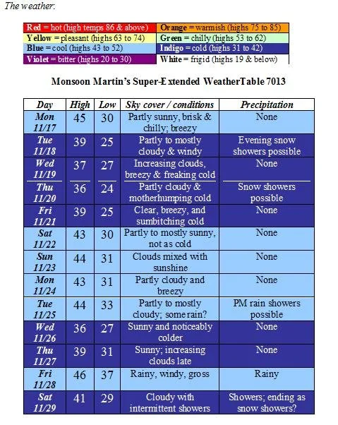
Monsoon's Weather Update for Monday, 24 November 2008
Habari mori,
Just a quick update to keep you "in the know" weather-wise...
Monday 11/24: clouds and milder, breezy with rain by late afternoon; some will be heavy. High 45, low 35.
Tuesday 11/25: partly to mostly cloudy with some showers & drizzle early and quite windy; few stray snow showers late and overnight? High 39, low 29.
Wednesday 11/26: breezy and chilly; partly to mostly cloudy. High 40, low 28.
Thursday 11/27: breezy, partly sunny with cloudy periods and some flurries; snow showers overnight? High 40, low 29.
Friday 11/28: chilly, breezy, rain late. High 44, low 36.
Saturday 11/29: clouds and sun, chillier; intermittent rain, especially early. High 43, low 30.
Sunday 11/30: sun mixed with clouds and cooler. High 37, low 26.
Monday 12/1: sunny and chilly. High 37, low 24.
Tuesday 12/2: partly to mostly cloudy with snow, perhaps mixed with rain. High 38, low 22.
Wednesday 12/3: clouds mixed with sunshine and much colder; flurries late? High 35, low 19.
Thursday 12/4: mostly sunny and very cold. High 34, low 18.
Friday 12/5: sunny with increasing clouds late. High 36, low 21.
Next weekend: very cold with snow likely Saturday or Sunday; highs in the low to mid 30s and lows in the low to mid 20s.
Beyond: continued cold with accumulating snow likely sometime during the week of Monday 12/8 through Friday 12/12.
Monsoon Martin's Complete Weather Forecast for Monday, 17 November 2008
Habari mori,
Bundle up, you-all!It’s going to be a brisk week.
Weather narrative: This week will be unseasonably cold as temperatures will not even make it out of the 30s for most of the week, and snow showers (with no appreciable accumulation) may pop up Tuesday or Thursday evening.(Average highs for this time of year are in the low 50s; lows are in the low to mid 30s.)
Things get a bit less chilly on Saturday and Sunday with highs creeping into the 40s, but a cold front coming in Monday or Tuesday of next week will usher in another period of unseasonable cold.
This will be followed by a period of instability toward the end of next week with rain possible on Friday the 28th and Saturday the 29th.
Beyond the forecast: Colder once again for Sunday into Monday to begin December.I think we’ll see accumulating snow for the first time during the second week of December.Stay tuned...
Monsoon Martin's Complete Weather Forecast for Thursday, 6 November 2008
Friends...
The next two weeks look overcast, chilly, and wet for the most part.Enjoy!!
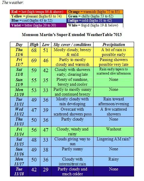
Weather narrative: After intermittent rain the last few days, we’ll have about 24 hours of relative clearing before we’re hit with some more rain—this time accompanying a strong cold front—late Friday night into early Saturday afternoon.Look for much cooler conditions as we begin the next week, with temperatures struggling to reach 50 on Monday through Thursday.Rain, some heavy, will move through the region on Tuesday night into Wednesday.
The next really good chance for rain is Friday the 14th into Saturday, when we could see windy conditions with heavy rain.Things cool off again for the remainder of next weekend and into the following week.
Beyond the forecast: A strong cold front rolling through sometime around Monday the 17th will usher in rain, followed by some of the coldest temperatures we’ve seen this season.By late that week, we will see high temperatures only in the upper 30s to low 40s, with overnight lows dipping well down into the 20s.
Monsoon Martin's Forecast Update / National Anthem Critique
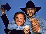
Really: John Oates is the best they could muster to sing the National Anthem at last night's Phillies World Series game???
A few things came to mind when I saw him belting out that swelling paean to militarism:
What--Daryl Hall wasn't available? He's the better-known of the two, and judging from Oates's missed high notes, the better singer.
There is a bagger at my neighborhood grocery store who looks like John Oates (at least, to me she does) and every time I see her, I hear the snippet in my head: "I can't go for that, no, noooooo..."
The National Anthems at the three Phillies home games were sung by Taylor Swift, Patti Labelle, and John Oates. I'll give you Patti, who is a Philly institution, despite her screeching, vocal gymnastics-filled rendition on Sunday night. But surely there were singers with Philly ties who would have been far better choices than Wyomissing's mewling country star Swift and the lesser half of Hall & Oates...
Tim McGraw. I hate his music, and he's from Louisiana, not Philadelphia. But at least he's got a legitimate tie to Philly: he's the son of late Phillies relief pitcher and World Series champion Tug McGraw.
Al Alberts. Of the Four Aces, and "Al Alberts Showcase" on channel six when I was growing up. "Try a Little Love"?! Would have been freaking classic. He could have even had dolled-up little kids telling lame jokes afterward.

Frankie Avalon, Philly-born teen idol.
Boyz II Men. Come on! I can hear the old-school harmonies now.
Fabian. Speaking of teen idols...
G. Love and Special Sauce. Could have injected a little blue-eyed funk into the proceedings...

The Delfonics. "Didn't I (Blow Your Mind This Time)" - great Philly soul. Or The Stylistics ("I'm Stone in Love With You"). Anything with a connection to songwriting greats Gamble & Huff.
Will Smith. Could have done a rap duet with Philly-born Eve. Would have been off the hazizza.
The Roots, with Jill Scott. These Philly-born and bred hip hop and neo-soul greats would have done an unforgettable and subversive version of the National Anthem.

McFadden and Whitehead, who wrote "Ain't No Stoppin' Us Now," which was the unofficial anthem of the Phillies' 1980 championship run. Oh, shit, they are no longer alive.
Just a thought...I wonder if they'll have a fourth National Anthem and team introductions for tonight's (or tomorrow night's) continuation of the suspended Game 5? If so, the Phillies would do well to take some of the suggestions above...
A forecast update for the next several days:
Today: Expect rainy, windy (with strong gusts), chilly conditions with highs only getting into the low 40s at most. Rainfall will be fairly steady but will not generally be heavy in our area.
Tonight: As temperatures dip into the low 30s this evening and overnight, we could see some wet snow mixing in with the rain. Persistent wind, leaves on the ground, and some periods of wet snow could reduce visibility and make the roads slippery in spots. Might be a nice night to hang out at home. Still pretty windy with a low of 31. No appreciable snowfall accumulation, except perhaps in areas like Allentown, northern Berks, and points north.
Phillies game: There's a churning system that's just taking its sweet time getting up and out of our area, so my feeling is doubtful that the Phillies game will be played tonight.
Tomorrow: Continued windy and chilly with a rain shower here and there. A snow shower or two early cannot be ruled out. Clearing and very cold late. High 43, low 29.
Thursday: Sunny and seasonably milder with diminishing winds. High 52, low 33.
Friday: Sunny and warmer still. High 59, low 35.
The weekend: Plenty of sunshine and seasonable with Saturday's high in the upper 50s and Sunday's high in the mid 50s. Lows both nights will dip into the mid 30s.
Next week: partly cloudy and autumnally ordinary for most of the week. Look for highs in the upper 50s to near 60; lows in the upper 30s to low 40s.
Beyond: Rainy, then cooler.

Go Phillies!

Update
on 2008-10-28 19:05 by Monsoon Martin
First of all, thanks to Steph for the tip: actually, Hall and Oates had been scheduled to perform the Anthem prior to Game 5, but since Hall fell ill, all we got was Oates. Also, after I uploaded the post, I checked the news on Google and saw that Major League Baseball had just announced that Game 5 will not be resumed tonight. Look for the conclusion of the game--and Philadelphia's first major sports championship in 25 years--on Wednesday evening. Maybe Hall will be recovered by then and can sing the harmony vocal for the Anthem, thus completing the rare Oates, then Hall H&O performance.
Monsoon
Update
on 2008-10-29 11:20 by Monsoon Martin
A final addendum: man did I hear from some Pink fans about excluding her from the list!

Alecia "Pink" Moore grew up in Doylestown--and in a Monsoon connection, sat behind Weatherlister Steph Luckey's friend in homeroom at CB West! She is best-known for the hit song "Get the Party Started," but my favorite Pink song has got to be "U + Ur Hand" from her latest release, an empowerment anthem whose speaker is tired of getting "hit on" in bars by sketchy men and assures all comers that, sorry, but "it's just you and your hand tonight." Harsh, but deliciously postfeminist!
Monsoon