
Monsoon's Complete Weather Update for Monday, 29 December 2008
Greetings to all during this fantastically lengthy holiday break!
We are having a fine holiday season and enjoying the fuzz-ball—aka BUNK—as he brings his sweetness and energy to our home.Bunk just turned 4 months old and is growing by leaps and bounds (and, is leaping and bounding all around the house).Below are two recent pictures of Bunk: in the first, he rapturously gnaws on the chew toy his Aunt Megan got him for Christmas; the second features Bunk in a recumbent pose on the hassock, looking just as cute as the day is long.


On to the weather, which has been screwy of late: a high of 67 at my house on Sunday, and the low on New Year’s Eve will be in the teens.I’m currently looking at three potential snow/ice events for the region: Friday 1/2, Tuesday 1/6, and Friday 1/9.See details below and stay tuned for updates...
The weather:
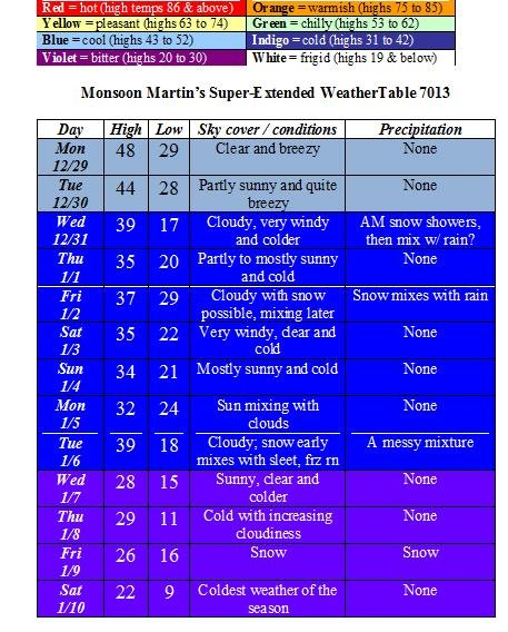
Weather narrative: Enjoy these next couple of days in the 40s, because it’s the last time we’ll see temperatures this high until about the third week of January.Very late Tuesday night a system will move through to our north, and it may clip us with some snow showers into Wednesday, but nothing really to worry about there.Watch out for high winds and powerful gusts on Wednesday.
Friday’s system is a bit more intriguing, in terms of the amount of moisture and temperature levels.I’ll send an update later in the week as that comes into clearer focus, but it could evolve into an accumulating storm.
The next issue looks to be Tuesday, with a potentially unpleasant mixture of snow and ice that could cause a disruption in our school schedule.The Friday after we return is looking snowy, too, but I’ll leave that speculation until we get closer to the event.At the very least, it looks like we’ll be very cold by then, so it doesn’t appear we’ll have to worry about mixed precipitation with that storm.
Beyond the forecast: Continued cold with a significant storm possible for mid-January...
Monsoon's Winter Weather Update for Wednesday, 24 December 2008
Temperatures stayed down overnight—I had thought they’d rise in the early morning hours—giving most of us in the forecast area a mixture of sleet and freezing rain. The result is a nice quarter-inch coating of ice on the sidewalks and cars this morning and some of us prepare to undertake some holiday travel.
The good news is that the temperature will be rising through the 30s by noon and into the mid 40s by this evening, so this winter weather event will become all rain—heavy at times, through late this evening—washing away much of this icy slush and making it easier to get the frozen crust off our windshields. Travel should be fine by late morning.
You’re waiting for “the bad news” now, aren’t you? Well, there is no bad news! It’s Christmas!! Pessimists. Humbugs.
On Christmas Day, we’ll see a mix of clouds and sun with a high of 43 and a low of 25.
Boxing Day looks a bit warmer with a high in the mid 40s and low in the low 30s.
This weekend looks rainy and drizzly with highs around 50 and lows in the mid to upper 30s.
Next week looks a little more seasonably cold with highs in the upper 30s to low 40s; lows in the upper 20s. I’m looking at a moderate snow event possible for December 31st, and then a more substantial snow event the 1st into the 2nd. I’m also looking at the 5th into the 6th for another potential event...
Stay tuned for updates on next week’s potential winter weather!
Have a great holiday!!
Monsoon's Weather Update for Saturday, 20 December 2008
I don’t know if my forecasting “expertise” is worth a plugged nickel anymore after my latest fiasco, but in case there’s anyone still listening, I thought I’d share my ideas about tonight’s storm as well as some upcoming weather events...
On Saturday we’ll see a few scattered flurries and snow showers. Snowfall begins in earnest sometime around or just past midnight, continuing through the late morning Sunday, when it could begin to mix with some sleet. Accumulations will be right around 2-3 inches for the forecast area of northern Lancaster and central and southern Berks Counties. Things will clear out Sunday afternoon—we’ll see some strong winds and may even see some sunshine—behind a cold front that will give us some of the most frigid conditions of the season so far. Watch for compromised travel conditions throughout the day Sunday, but especially in the morning.
Monday will be windy and very cold with a high near 30 and a low around 13.
Tuesday will be a bit less bone-chilling with a high in the mid to upper 30s and a low in the upper 20s. Precipitation will arrive as sleet overnight, but change to rain showers throughout the day and evening Wednesday, when the high will reach into the mid 40s.
On Thursday we’ll see plenty of clouds and a few rain showers with highs in the low 40s and lows in the upper 20s.
Friday will also be cloudy and mild with similar temperatures to Thursday’s and perhaps a passing rain shower or two.
Next weekend is looking cloudy with spotty rain and drizzle, the heaviest being Sunday morning. Highs are in the low to mid 40s; lows in the low 30s.
The following week will be seasonably colder again with highs in the mid to upper 30s and lows in the low to mid 20s.
The New Year will begin with even colder temperatures—highs just in the upper 20s to low 30s—and perhaps a bit of snowfall around the 4th or 5th.
I’ll send out updates as necessary when weather conditions warrant.
Take care and have a great holiday break!
Monsoon's Forecast Contrition Haiku for Friday, 19 December 2008
Inconceivable
Too warm for frozen precip
Rain / snow line crept north
Said bye yesterday
And yet here we are again
A little awkward
Another blown call
Monsoon hangs his head in shame
Happy holidays!
Monsoon's Winter Storm Update for Thursday, 18 December 2008
And now for the hotly awaited update on Friday’s weather event...
Snow begins around 4 or 5am and falls quite heavily until mid to late morning, accumulating 2 to 3 inches. Snow mixes with sleet and freezing rain throughout the afternoon, then tapers to snow showers and freezing rain/drizzle by early evening. Precipitation ends by 6 or 7pm. Afternoon high will only be 33 or 34. Travel will be somewhat compromised in the early morning, and will become more treacherous by the late morning and early afternoon.
I will send an update later today or tonight if my thinking changes on this event.
Accumulations:
There’s more moisture associated with this fast-moving system, so accumulations will be more impressive than Tuesday night’s storm. 2 to 4 inches of snow and ice in the forecast area; perhaps as much as six inches north of Berks County. An inch or two of snow and sleet in Philadelphia and the immediate suburbs.
Delays and cancellations:
Chance of delay Friday, 90%.
Chance of school cancellation Friday, 70%.
Beyond:
We’re entering a very cold and quite active period in terms of wintry weather. Winter storm potential exists Saturday the 20th into Sunday the 21st; Wednesday the 24th into Thursday the 25th; and Friday the 26th into Saturday the 27th. Stay tuned throughout the holiday break for periodic updates...
Monsoon's Quick Winter Weather Update
An update on my thinking for this tricky storm:
A period of light snow and sleet will move through this morning; then in the early afternoon we’ll see a lull in precipitation until a larger area of moisture comes through. In the very late afternoon and evening look for snow, mainly. Overnight and into Wednesday morning we’ll see a mix of snow and sleet generally, with the event ending as freezing drizzle or just plain scattered rain showers on Wednesday morning.
Totals:
2-3 inches of snow mixed with sleet in the Reading area; perhaps an inch or two more in northern Berks and the Lehigh Valley.
An inch or two of snow mixed with plenty of sleet and freezing rain in Lancaster County, southern Berks, Chester and Montgomery Counties.
Mainly rain with perhaps a coating to an inch of sleetish slop in the Philadelphia area and points south.
Adjusted cancellation predictions:
Tuesday early dismissal: 55%
Wednesday delay: 75%
Wednesday cancellation: 35%
Monsoon's Forecast Update / Shoe-Flinging Analysis
Since I heard about this on Sunday and saw the video today, it has still not gotten old, and will never get old. Surely by now you’ve heard that our outgoing President, George W. Bush, had to bob and weave like Floyd Mayweather to avoid two shoes being chucked at him—with impressive aim and velocity—by an Iraqi reporter at a news conference in the Prime Minister’s office during Dubya’s surprise visit on Sunday. It was unquestionably the most eloquent use of footwear to make a political statement since Nikita Khrushchev banged his shoe on the table at the UN in 1960. (And surely you’ve also heard by now that one of the most vehement shows of disrespect in the Muslim world is to show the bottom of one’s shoe to another—or, more directly, throw it at him or her—because it’s akin to saying, “You scum-sucking pig! You son of a motherless goat!”*)
Here is the video, taken from Brazilian television (I cannot explain why, but the Portuguese somehow makes it that much funnier). FYI: search YouTube for clips that include slow motion and alternate angles, if you care to analyze the footage—pun intended—like it’s the Zapruder film and search for a second shoe-lobber. I’m quite content to watch this clip, though.
Anywho, I have a forecast update for you—potential for some hazardous driving conditions and winter weather over the coming days. Stay tuned, as always, for updates, as things can change quickly with a storm like this.
Tuesday 12/16: It’s difficult to believe given today’s very mild temperatures in the mid 60s, but by Tuesday morning’s commute, the temperature will only be in the upper 30s; it will drop to freezing by the time school lets out Tuesday. What this means for us is that it will be cold enough—both in terms of surface temperatures and the air aloft—to precipitate in a wintry fashion and create travel troubles.
Rain in the morning, mixing with freezing rain by late morning; changing over to snow by 1 or 2 in the afternoon. Snow continues intermittently, making travel a bit dicey; snow intensifies later and overnight into Wednesday morning, bringing a total accumulation of snow and ice to 2 to 4 inches. (Philly suburbs get less accumulation but more icing; Lehigh Valley and northern Berks could see as much as six inches of snow, depending on when the changeover takes place.)
Cancellations / delays: The snow and ice in particular make Tuesday evening’s commute potentially dodgy, so be careful. Tuesday AM delay 15%; cancellation 10%; early dismissal 35%.
Wednesday 12/17: Snow ends mid-morning, possibly mixing with sleet. High 38, low 29.
Cancellations / delays: Wednesday AM is the most treacherous; depending on snow totals, we could see some cancellations. Wednesday AM delay 85%; cancellation 45%.
(Remember that the cancellation and delay potentials are evaluated separately, as distinct events, and you should not look for percentages to add up in any particular way. For example, when I say there is an 85% chance of delay on Wednesday, there is no converse percentage implied. Can a statistics teacher out there help me explain this more clearly? I’m not even sure what the hell I mean.)
Thursday 12/18: Cloudy and milder with rain possible on and off. High 42, low 34.
Friday 12/19: Overcast and windy with a shower or two; snow may develop later on. High 44, low 31.
Saturday 12/20: Partly cloudy and colder. High 38, low 27.
Sunday 12/21: Overcast with a few breaks of sunshine; some snow showers are possible. High 35, low 21.
Monday 12/22: Sunny, clear, windy and cold. High 33, low 18.
Tuesday 12/23: Sunny, clear, breezy and colder. High 28, low 16.
Wednesday 12/24: Partly to mostly cloudy with snow possible late. High 34, low 22.
Thursday 12/25: Cloudy and cold with no precipitation around today (though given the cold temperatures, some snowfall from the preceding week or so could still be on the ground, technically making it a “white Christmas”). High 33, low 21.
Friday 12/26: Overcast with snow developing; could accumulate. High 34, low 26.
Next weekend: Very cold and snowy with highs struggling to get out of the 30s.
Beyond: A bit milder the last few days of 2008 and into 2009, it appears.
*Be the first to email me with the source of this reference (and another accurate quotation from the same source) and you will win a priceless gift: prominent mention in this vaunted space in my next posting, along with my deepest admiration.
Monsoon Martin's Forecast Contrition Haiku
I present the first-ever (and surely, not the last) Monsoon Martin Forecast Contrition Haiku. I chose the form haiku (in its English incarnation, consisting of three lines with five, seven, and five syllables) because the original Japanese form sought to explore the inscrutable essences of nature and its processes. Since that is what I do—try to make sense of the mysteries of meteorology—it seemed appropriate. Please to enjoy:
Besieged weatherman
Gave colleagues hope for delay
Here we [bleep]ing are
Considered quitting
But I’ll stay to forecast on
If you will have me
Break in the action
Drizzle when I took Bunk out
“Tail end” is lagging
Mild temperatures
Stayed mid to upper 30s
No snow, no pellets
Cold air battles warm
Warm dominates surface temps
Cold hangs head in shame
Morning snow showers
May have students clamoring
Dream on, my young friends
Next Thursday, Friday
Monsoon still holds out some hope
Accumulations
Looking ahead now
Snow 24th, 25th?
Hope for White Christmas
Take care and stay tuned for updates...