
Monsoon's Weather Update
Hey--
I meant to get this out earlier, but I had a killer migraine headache that kept me in bed most of the morning.
The snow that many of us see falling right now can continue on and off through late afternoon, accumulating as much as an inch in some places. Please use caution when driving--especially on secondary roads--but generally things should not get too treacherous.
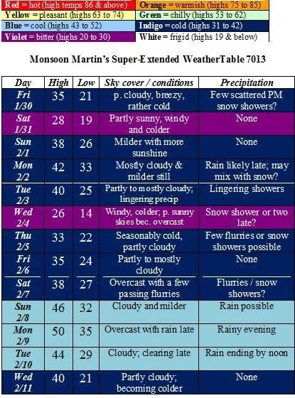
Monday – a few light to moderate snow showers and flurries through late afternoon, accumulating in some places as much as an inch; cloudy and seasonably cold. High 32, low 18.
Tuesday – partly cloudy, breezy and colder. High 28, low 12.
Wednesday – plenty of sunshine, breezy and continued cold. High 26, low 15.
Thursday – partly to mostly sunny and a bit milder. High 37, low 24.
Friday – mostly cloudy with a chance of a few snow showers, not amounting to much. High 36, low 25.
The weekend – windy with more clouds than sun; a few flurries or light snow showers are possible on Saturday. Highs in the mid 30s, lows in the low 20s.
Next week – colder with highs below freezing and lows in the teens. Snow is possible on Tuesday the 27th and Thursday the 29th.
Beyond – the following weekend looks a bit milder (highs toward 40) and perhaps some rain.
Monsoon's Forecast Update - Winter Weather
Update on tonight's weather event:
Snow showers will not begin until 9 or 10pm; snow will actually be moving in within the next few hours, but the air is so dry it will have trouble reaching the ground at first. Accumulations will be light—up to two inches in northern Berks, Allentown, and points north; a coating to an inch in southern Berks, northern Lancaster, and Harrisburg. The track of this clipper could shift southward and produce up to 3 inches over most of the forecast area, but this is quite unlikely. Light snow showers and flurries will continue intermittently into Thursday morning, tapering toward mid-morning.
Conditions will become significantly colder following this system. After a high of only about 24 on Thursday (when very windy conditions will actually make it feel like it’s in the single digits), the temperature will fall to about 4 at night. Afternoon temperatures on Friday will only reach about 14 before falling to zero overnight (with wind chills in the negative teens).
Chance of cancellation Thursday: 30%
Chance of delay Thursday: 55%
Chance of cancellation Friday: 35%
Chance of delay Friday: 50%
Cold, but not as cold, over the weekend with highs in the 20s and lows in the teens; a chance of some stray snow showers overnight Saturday into Sunday. Stay tuned for updates on that event.
Next really good chances for snow are Friday the 23rd and Tuesday the 27th.
Monsoon's Complete Forecast for Monday, 12 January 2009
Habari mori,
Here’s a complete forecast for the coming two weeks, which includes several opportunities for wintry weather.This Tuesday we should just see some flurries and brief snow showers, while Thursday’s clipper system will likely skirt our area to the north (as Saturday’s event did, giving us an icy coating to an inch instead of half a foot).
The weather:
Weather narrative: Temperatures will reach into the balmy lower 40s tomorrow ahead of a cold front that will give us the most bitterly frigid temperatures in a few years—highs in the mid to upper teens and lows approaching zero.Two winter weather systems look as though they will just miss us: Tuesday night, the bulk of the moisture will pass well to our south (and some to our north) leaving us with some snow showers and flurries; on Thursday, forecast models suggest a clipper system will pass to our north, giving northern PA and NJ the most significant accumulation and leaving us with only a coating at the most.
As the frigid conditions subside a bit, we could see some snow showers or flurries on Sunday, but again, nothing to get excited about.
Highs around freezing for the first half of the week; snow is likely sometime around Thursday the 22nd.Perhaps some snow on the weekend of the 24th-25th as well.
Future weather: Highs in the 30s; perhaps a bit of a “January thaw” with highs getting into the 40s and even approaching 50 toward month’s end.
Delay & cancellation potentials: I’m not sure if there are ever cancellations or delays due to extreme cold, but this may be the time to think about it.(Think about how cold it was this morning, at 24 degrees, then think about the fact that on Thursday morning it will be twenty degrees colder.)Delay / cancellation potentials for the remainder of this week...
Tuesday 1/13: None.
Wednesday 1/14: cancellation 10%; delay 20%
Thursday 1/15: cancellation 20%; delay 35%
Friday 1/16: cancellation 25%; delay 40%
Monsoon's Weekend Storm Update
A weekend storm update.
The straight dope on Saturday’s snowstorm: AM light snow showers and flurries are possible, but the bulk of the snow will fall after around 11am or noon. Snow will fall steadily, but at varying intensities, tapering late Saturday night to very early Sunday morning (around 1 or 2am) with a bit of sleet possibly mixing in late.
Total accumulation in the forecast area: 4-6 inches. High 31, low 22.
I will send an update tonight if the forecast track, timing, or accumulation change appreciably.
Sunday looks cloudy to start with some clearing later. High 29, low 14.
Next week is looking cold with highs just at or below freezing and lows in the upper teens. Snow is possible Tuesday—stay tuned for updates. By week’s end we’ll see the coldest weather of the season: highs struggling to reach 20, lows in the mid-single digits—and wind chills well below zero.
Monsoon's Forecast Adjustment, 8pm
Snow did not begin as early as I'd thought it would due to extremely low dewpoints (dry air) preventing afternoon precipitation from reaching the ground. Sleet and freezing rain will change to plain rain around or just after midnight. Temperatures will rise above freezing right around AM commute Wednesday (6-7am) so travel could still be treacherous. A prolonged period of sleet and freezing rain tonight could result in an ice buildup on power lines, back streets, and trees, resulting in scattered power outages and the like. My updated percentages:
Delay, Wednesday: 55%
Cancellation, Wednesday: 20%
Monsoon's Quick Winter Weather Update
Habari mori,
My forecast for today and tomorrow isn't changing substantially, but I wanted to adjust a few things:
The snow/sleet mix will arrive late morning or early afternoon, earlier than I'd predicted yesterday. There will also likely be a prolonged period of ice overnight, possibly causing major havoc with downed limbs, power outages, and travel difficulties.
Adjustments to percentages:
Chance of early dismissal Tuesday: 45%
Chance of delay Wednesday: 85%
Chance of cancellation Wednesday: 50%
Monsoon's Winter Weather Update for Monday, 5 January 2009
Hey there...wanted to give you an update on the coming weather. A reminder for those from far and wide reading this: my forecast area roughly covers central and southern Berks and northern Lancaster Counties.
Tuesday 1/6 – mostly cloudy with snow showers developing around 4 or 5pm, continuing through the evening, accumulating an inch, perhaps two in a few locations. Snow mixes with sleet and freezing rain, then changes over to ice around or just before midnight, continuing to 5 or 6am. Travel will be particularly treacherous later Tuesday evening and during AM rush Wednesday. High 34, low 28.
Chance of early dismissal Tuesday: 15%
Chance of delay Wednesday: 75%
Chance of cancellation Wednesday: 30%
Wednesday 1/7 – beginning with icy conditions, then precipitation turns to all rain and tapers by late afternoon. High 36, low 30.
Thursday 1/8 – mostly cloudy and very windy with snow showers possible later in the evening. High 34, low 22.
Friday 1/9 – clear to partly cloudy, somewhat windy and cold. High 30, low 19.
Saturday 1/10 – breezy and overcast with intermittent snow showers, perhaps accumulating. (Stay tuned for updates.) High 31, low 21.
Sunday 1/11 – partly cloudy and breezy. High 28, low 15.
Next week – very cold with highs only in the mid to upper 20s and lows in the mid to upper teens. I’m looking at Monday 1/12 and Thursday 1/15 for possible snow events.
The following weekend – frigid with lows perhaps dipping into the single digits at night.
Beyond – maybe a “January thaw” toward the 20th with highs approaching the 40s and even 50s.
Monsoon's Quick Update for New Year's Day 2009
Happy New Year!
Thursday night: a few clouds, cold, low 17.
Friday 1/2: breezy and mostly cloudy with a few snow showers, mostly in the morning; a few places could see a coating to an inch of accumulation, but most will see very little. Clearing late. High 36, low 22.
Saturday 1/3: partly to mostly sunny and rather windy—though not nearly as windy as New Year’s Eve Day. High 38, low 20.
Sunday 1/4: mostly cloudy with rain, mixing with snow, developing in the afternoon. Most precipitation will be light and accumulations will be trace to coating. High 35, low 31.
Next week: highs in the mid to upper 30s, lows in the mid to upper 20s throughout the week. Snow is still possible on Tuesday evening and overnight, as well as Thursday the 8th. Monday will be breezy and Thursday (snow or no snow) will be very, very windy. I will provide updates as these events draw nearer and come into sharper focus.
Next weekend: colder with highs in the upper 20s and lows in the teens.
Thereafter: the following week is looking pretty active, with a couple of systems potentially affecting our travel and schedules on Tuesday the 13th and Wednesday the 14th.
Stay tuned for updates...