
We Want the Bunk! Gotta Have that Bunk! (ow)
Habari mori,
The purpose of this post is twofold: to update you regarding my thinking about the potential storm next week, and to update you about the growth of The Bunk.Starting, then, with the most important news of
the two...
Bunk just turned five months old on January 24th and is filling out nicely. He’s every bit the delight he was when he first came into our lives two months ago, and his training continues to go swimmingly. (He’s mastered “sit” and “down” and is working on “stay,” “come,” and “leave it.”)
I thought I’d share some new pictures of Bunk, who now weighs 32 pounds—he was around 22 when we got him—and will apparently not stop growing until sometime this summer!In the first picture, Bunk is happily stretched out on the rug in our bathroom; in the second—an action shot—Bunk is furiously trying to bite the hot air that is being blasted from the hair dryer by his cruel daddy. And the final picture is a close-up of Bunk’s sweet face as he sleeps serenely at the end of the couch.

The Bunk at 5 months

The Bunk at Rest

The Bunk vs. Hair Dryer
An update about the Nor’easter that could affect our weather on Monday and Tuesday: the models continue to be out of agreement, but trends suggest this is going to be a bust.We’re still nearly 48 hours from the event (or at least the part of the event that could be interesting), so a lot can happen between now and then, but here’s what I’m thinking as of now...
Monday will bring rain showers by late afternoon continuing into the overnight hours, with a few snowflakes mixing in.Maybe as much as a coating to a half-inch by Tuesday morning, but nothing to worry about.High 41, low 33.
Tuesday will see some snow showers and increasing wind, but since the low looks to be positioning itself off the coast, the storm will track to the east of what was originally thought, the amount of moisture will be less, the foot-plus snow dump will be averted.High 34 low 18.
Wednesday will see some lingering flurries, high winds, and much colder conditions.High 26, low 14.
The remainder of the week looks sunny, seasonably cold, and dry: highs around freezing and lows in the low 20s.
The weekend looks cloudy and milder with highs in the upper 30s to near 40, and lows just below freezing.
The following week is looking a bit colder; I’m still looking at the 13th and 14th for something interesting...
Monsoon Martin's Complete Weather Forecast for Friday, 30 January 2009
Here's a forecast to give you some idea of the weather we'll be seeing through the middle of February...
The weather...
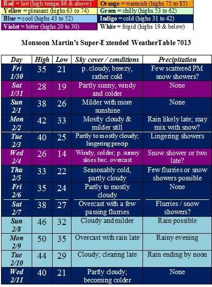
Weather narrative: As far as snowfall is concerned, we may have a few snow showers today, but this is nothing to worry about.There’s a system on Monday into Tuesday that we in the weather community are looking at with some interest, but as of now it looks like mostly or all rain.I will keep you posted if I see anything of concern.
Otherwise, watch out for pretty strong winds on both Saturday 1/31 and Wednesday 2/4.
Beyond the forecast: The following week (beginning with 2/9), we’ll see generally milder weather with highs in the 40s to approaching 50, and plenty of moisture in the beginning of the week; colder temperatures but no snow (or so it appears now) for the remainder of the week.I’m looking at 2/14 and 15 for something interesting in the way of a major storm.
Monsoon's Tuesday afternoon update...
I'm sticking with all aspects of my earlier forecast except the timing of the changeover: it appears warmer air will move into the upper levels of the atmosphere earlier, causing a sooner changeover. So it is: snow until just after midnight, when it will mix with then change over to sleet and freezing rain.
Since surface temperatures will still be below freezing when we are to commute in the morning, I think things still look favorable for a delay or cancellation.
Freezing rain may change over to all rain in the later morning and afternoon before ending as snow showers in the evening.
For Wednesday... Chance of cancellation: 75% Chance of delay: 80%
Monsoon
Monsoon Martin's Final Call
Alright, here’s the final call for this storm.
The messenger of Allah, the Most Honorable Elijah Muhammad, teaches that...
Sorry, got confused again about the “final call” thing.
After the flurries and brief snow showers this morning, we’ll have partly to mostly cloudy conditions for most of the day—this will give us just a dusting, perhaps an inch in isolated areas.
The actual storm will move in around 6 or 7 tonight, when it will begin snowing fairly steadily. Snow will continue in varying intensities overnight. We should have 4-5 inches on the ground when we wake up and wait for the calls on Wednesday morning.
Snow will mix with, then change to, sleet and freezing rain sometime between 8am and 11am Wednesday, adding another dimension of danger to this event in terms of driving hazards, power outages, and the like. The heaviest precipitation is likely to arrive in this period generally (6am to noon) so this could get quite nasty.
Precipitation may change back to snow briefly in the late afternoon or early evening as it tapers off and the storm pulls away.
Early dismissal Tuesday: 20%
Delay Wednesday: 60%
Cancellation Wednesday: 85%
Delay Thursday: 40%
Cancellation Thursday: 10%
Total accumulation of snow and ice: 4 to 6 inches, with isolated areas (particularly northern Berks) getting up to 8 inches.
Monsoon's Monday afternoon storm update
Monday afternoon update:
We won’t see a lot of snow overnight tonight and into Tuesday morning / afternoon. Maybe a coating to an inch in isolated areas by Tuesday morning.
Snow intensifies around 5 or 6 Tuesday evening (so I think the Tuesday commute home from school shouldn't be too bad) and continues through the night. Snow mixes with and changes to sleet on Wednesday morning, creating more travel difficulties as perhaps a quarter-inch of ice accumulates on top of the snowfall.
Delay Tuesday: 10%
Cancellation Tuesday: 15%
Early dismissal Tuesday: 35%
Delay Wednesday: 95%
Cancellation Wednesday: 70%
I’ll make my “final call” (not the Nation of Islam newspaper, but my last, official forecast on this event) on Tuesday morning, with further updates as needed.
Monsoon's Initial Call on the Midweek Storm
Habari mori,
We’re still 60 hours from the event, so my call can (and probably will) change between now and then. (In other words, don’t hold me to it!) That said, here’s my initial call:
Light snow and flurries beginning on Tuesday late afternoon and evening, becoming steadier and heavier Tuesday night and overnight into Wednesday. Snow will be heaviest Wednesday morning, continuing throughout Wednesday afternoon and evening, then tapering by early Thursday morning.
Some forecast models are presenting the chance for “heavy” snow with this system, so we might be hearing quite a bit about it as it approaches.
My feeling in terms of cancellations and delays: no early dismissal Tuesday; widespread school cancellations Wednesday; and widespread delays on Thursday morning. Accumulations 4 to 6 inches generally.
Stay tuned for updates on timing, amounts, and delay/cancellation predictions.
Monsoon's Quick Weather Update for Friday, 23 January 2009
A quick forecast update...
Today will be partly to mostly cloudy and somewhat mild, with a high of 46; then getting down to 20 overnight.
Saturday looks mostly sunny, windy and colder. High of 31, low of 12. Wind chills at night will approach zero.
Sunday will be partly sunny, breezy and cold. High 26, low 11.
Next week looks like more of the same: highs in the mid to upper 20s; lows in the low to mid teens through Wednesday. Snow is possible Tuesday night and Wednesday, so stay tuned for updates as this event comes into sharper focus. Thursday will be a bit milder with highs in the upper 30s and lows in the mid 20s. Maybe some rain or snow showers on Thursday.
Next weekend looks fairly typical for this time of year: highs in the mid 30s, lows in the mid 20s.
Beyond: cold again with highs not getting out of the 20s for the first week of February. There are some indications that the pattern is shifting and we could get walloped with at least one or two good snowstorms from the 2nd through the 4th.
Monsoon's Percentages for Cancellation and Delay Tuesday
Now that the snow is pulling away from our area and most of us have made it home, I'm getting all kinds of reports about how nasty the driving is: slippery areas (especially on bridges) and accidents galore on the highways (I've heard 222 and 78 are notable hazard spots). Might be a good idea to limit your travel tonight.
Things may improve a bit overnight with some salting and plowing, but particularly on secondary roadways, things are going to be dicey during the Tuesday morning commute.
My predictions for cancellation and delay Tuesday 1/20:
Cancellation: 25%
Delay: 70%