
Monsoon's Weekend Weather Update
An update on this weekend’s weather...
Friday: much milder with a high in the mid to upper 50s. Some rain, particularly late in the morning and scattered throughout the afternoon. Clearing somewhat, breezy and getting down to the mid 30s overnight into Saturday.
Partly cloudy and breezy on Saturday with a high around 43. Scattered periods of light snow and sleet arriving at night, with perhaps a coating but no significant accumulation. Use caution when driving during a period of frozen precipitation. Low 28.
Breezy and colder Sunday with a high in the upper 30s and lingering snow and rain showers, mainly in the morning. Overcast throughout the day; overnight low in the low 20s.
On Monday there is the potential for snow throughout the day from a coastal storm, but right now strong indications are that it will hug the coast and largely miss our area. (Stay tuned for weekend updates.) Right now the call is: mostly cloudy, windy and colder with a high of 30 and a low of 21. It’s a near-hit with accumulations of a coating to an inch.
Becoming gradually milder throughout the week with no additional precipitation expected; by Friday, look for a high above 50.
Looking ahead: maybe a snowstorm around March 9th or 10th. But let’s not get our hopes up.
Monsoon's Weather Forecast / Bunk Birthday Bash
Tuesday, February 24th is the 6-month anniversary of The Bunk’s birth, and he is still (at about 35 pounds now) just as wonderful as the day we got him in November.He’s been a little finicky with his food, and a couple of incidents have driven (rather graphically) home just how sensitive his stomach can be.But I think we’ve got a good handle on his intake now, and of course the folks at Total Dog continue to take great care of him.
Here are a couple of recent photos. In the first, The Bunk merrily chews his rubber chicken chew toy. The second is a bird's-eye view of The Bunk with the evidence of his lavatory marauding. (The Bunk has an insatiable appetite for facial tissues—preferably used—as well as toilet paper, paper towels, and the like.In fact, Sasha and Ruthie had that same proclivity. Does anyone know why dogs go gaga for these sorts of things?I mean, I get that it’s fun to tear it up, but beyond that, is there a reason? Are cats like this, too? I am fascinated.) And the third shot is of The Bunk napping sweetly on the big pillow.
Happy Birthday, big man!

The Bunk Gnaws Chicken, On the Alert.

Exhibit A: The Bunk Caught in Brazen T.P. Raid.

The Bunk Bunks Out Blissfully on the Big Pillow.
So, the weather...as I said in my last communication, I’m thinking we are approaching spring rapidly.Notwithstanding Tuesday night’s frigid temperatures, there’s little evidence that we’ll have to deal with “wintry” weather (precipitation or chills) for much longer. Check it out...
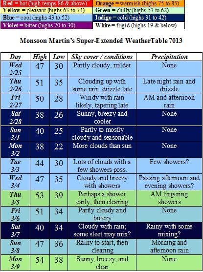
The weather:
Weather narrative: For the remainder of the week, we’ll see far milder temperatures.Some rain is possible on Thursday into Friday, after which things will cool off somewhat again for the weekend.
Next week will start out seasonably cool, but temperatures will once again rise into the 50s by week’s end. Rain is possible on Tuesday and Wednesday, and into Thursday morning. If a cold front coincides with some weekend precipitation, we may see some sleet on or around the 7th, but then things moderate again.
Beyond the forecast: Warming up as we approach mid-March.
Monsoon's Quick Update for Friday, 20 February 2009
Today will be cold and rather windy with a high only around freezing and an overnight low of 19. We could see a stray flurry or two this morning.
Saturday will be not quite as cold with partly cloudy skies and a high getting up to 40. Clouds roll in later ahead of a clipper. Light snow begins sometime around 8 or 9 at night and continues off and on until about mid-morning on Sunday. Total accumulations for this weak and widely scattered event will be nothing more than a coating to an inch. (I will send an update if this changes.)
Sunday will begin with a little snow, then turn out partly cloudy and rather windy. High 35, low 21.
Next week is looking breezy and cold to start with highs in the mid 30s and lows around 20. A little milder toward the end of the week with highs creeping into the 40s; rain is possible on Thursday and Friday.
Next weekend looks mild and pleasant with highs in the mid 40s and lows just below freezing.
The next chances for snow are March 2nd-3rd and March 5th-6th as it turns colder and a couple of potential weather-makers roll through, but given our track record with potential storms this winter, I wouldn’t hold your breath...
Have a great weekend!
Monsoon's Weather Update for Wednesday, 18 February 2009
There’s one storm brewing for Monday the 23rd—which could disappoint us, as have many others this winter—but I’m getting the feeling (a full month before the vernal equinox) that the season may be coming to an end. (Am I saying this because the opposite of what I’ve stated has come true so often? A little reverse psychology on Mother Nature? Or do I really believe this? I cannot say.)
Anywho: here’s the weather...
Wednesday – chilly and breezy with snow showers starting by late morning—accumulating not more than a half-inch in most places, and mainly on grassy surfaces—becoming rain showers in the afternoon, tapering late. High 40, low 33.
Thursday – partly to mostly cloudy and windy with a brief snow shower or two possible, particularly in the morning. High 42, low 24.
Friday – colder and quite windy with partly cloudy skies. High 33, low 21.
The weekend – cloudy Saturday with a high in the mid 30s; Sunday will see clouds and sun with a high around freezing and a few snow showers or flurries possible, mainly in the morning.
Monday – overcast with snow possible; stay tuned for updates on this one, which could be an impressive event if it falls right. High 34, low 23.
Tuesday – seasonably milder and partly cloudy. High 38, low 26.
Wednesday – overcast with a bit of rain and/or snow possible. High 36, low 30.
Thursday – rainy. High 46, low 39.
Friday – rainy. High 48, low 36.
Next weekend – partly cloudy and seasonable with highs in the mid 40s and lows at or just below freezing.
Beyond – colder with highs in the 30s and some frozen precipitation possible on Monday the 2nd and/or Tuesday the 3rd.
Nothing Neither Way?
It’s been a season of near-misses, with lots of storms either heading to our north or to our south, and few direct hits. (Actually, shouldn’t the term be “near-hit”? I present this George Carlin monologue to honor his recent passing and celebrate his unassailable logic.)
Here's one they just made up: “near miss.” When two planes almost collide, they call it a “near miss.” It’s a near hit. A collision is a near miss.(WHUMP!)“Look, they nearly missed!” ... “Yes, but ... not quite.”

The storm has taken a turn well to our south, so I don’t even think we’ll see a whole lot of cloud cover—let alone any precipitation—for Valentine’s Day.The next good chances of a snow event are Monday and Thursday.See below for details.
Today will be partly to mostly sunny with those high winds subsiding by late morning or so.High in the mid 40s, low in the low 20s.
Valentine’s Day looks partly cloudy with a high in the low to mid 40s and a low again in the low 20s.
Sunday will bring more of the same: seasonably cool weather and plenty of sunshine with highs in the mid 40s and lows in the mid 20s.
Presidents Day could bring some snow late—though it’s looking increasingly as though that system will also slide to our south.I will let you all know if that changes.For now, let’s call is partly to mostly cloudy and colder with a high of 37 and a low of 20.
Tuesday will be partly to mostly sunny and seasonable: high in the upper 30s, low in the mid 20s.
Wednesday will be mostly cloudy with a chance for sleet and snow, particularly late and overnight into Thursday.High 34, low 28.
Thursday may begin with some snow showers or flurries; remaining cloudy and windy for the day.High 37, low 24.
Friday will see the beginning of a trend toward colder-than-normal conditions: windy with perhaps a lingering snow shower or flurry; a high only in the low 30s, a low in the upper teens.
Next weekend (the 21st and 22nd) is looking interesting weather-wise, particular toward the latter half, which holds the chance for snow and sleet.
Beyond: seasonably cold with highs in the upper 30s to low 40s; lows generally in the mid 20s.Next good chance for snow is Tuesday the 24th.
Monsoon's Forecast for Tuesday, 10 February 2009
I think we’re going into a more active and chillier pattern for the 2nd half of February. Here are the details...
Tuesday night 2/10 – cloudy and mild with overnight lows only in the mid to upper 30s.
Wednesday 2/11 – cloudy and unseasonably mild with showers in the afternoon, the periods of rain in the evening. A thunderstorm may even roll through some places at night. High 64, low 48.
Thursday 2/12 – cooler and very windy with sustained winds in the 20-30mph range; gusts in the 40-50mph range. High 46, low 31.
Friday 2/13 – breezy and partly cloudy with a high of 42 and a low of 23.
Saturday 2/14 – overcast with snow or snow showers possible. Right now I don’t think we’re going to see a whole lot of accumulation from this system, but I’ll keep you posted. High 36, low 24.
Sunday 2/15 – breezy with plenty of sunshine. High 37, low 21.
Monday 2/16 – breezy with plenty of sunshine. High 34, low 20.
Tuesday 2/17 – partly cloudy and seasonably cool. High 36, low 24.
Wednesday 2/18 – overcast with snow possible. High 35, low 27.
Thursday 2/19 – partly cloudy. High 42, low 28.
Friday 2/20 – cloudy with snow possible. High 34, low 22.
Next weekend – partly to mostly cloudy generally with highs in the mid 30s and lows in the low 20s.
Beyond – I’m looking at a possible snow event around the 23rd or 24th.
Monsoon's Weather Update for Thursday, 5 February 2009
After this morning’s reading of 8 at my house (eight!) it’s difficult to believe that we’ll see temperatures in the mid 50s this weekend. But believe it.
Next good chance for snow will have to wait for that mid-month system I’ve been talking about.
Today: plenty of sunshine, but windy and bitterly cold. High 22, low 12.
Friday 2/6: sunny and not as cold. High 35, low 21.
Saturday 2/7: partly to mostly cloudy and milder. High 47, low 33.
Sunday 2/8: windy and unseasonably mild with partly cloudy skies. High 54, low 38.
Monday 2/9: mostly sunny, breezy and cooler. High 42, low 27.
Tuesday 2/10: mostly cloudy with rain developing late. High 44, low 30.
Wednesday 2/11: overcast and breezy with intermittent rain and drizzle. High 45, low 36.
Thursday 2/12: overcast; cooling later with perhaps a rain or snow shower. High 38, low 22.
Friday 2/13: partly cloudy with moderate winds. High 36, low 20.
Next weekend: colder with snow likely the 14th into the 15th. This could be enough to cancel school on Monday the 16th, for those of you who have it. (Mifflin has off.)
Beyond: cold with highs just below freezing and lows in the upper teens; quite windy to begin the week. I’m looking at a system on the 19th and 20th for some possible snow.
Monsoon
"Big" Storm a Bust...
The “triggers” that would have led to a major storm do not appear to be in place, so I think we’re going to be left with an extended period of light to moderate snowfall and flurries from this evening through Tuesday night. Here’s how it plays out:
Monday: a bit of rain develops by mid-afternoon, quickly changing to snow, perhaps giving us a coating by evening commute. Expect a high of 40 in the early afternoon, dropping through the rest of the day. A few snow showers at night and overnight as temperatures dip into the mid 20s.
Tuesday: intermittent snow showers with perhaps a period or two of heavier snowfall, tapering off in the late evening. Snow will generally be light, and will cause relatively insignificant traffic hazards. High 32, low 18.
Wednesday: windy and very cold with increasing sunshine. High 24, low 12.
Beyond: a trend toward moderating temperatures (highs in the 40s, lows at or just below freezing) begins this coming weekend.
Accumulations: fairly light over all. My call is 1-3 inches over the forecast area from Monday evening to Tuesday night.
Delays and cancellations:
Monday early dismissal, 25%
Tuesday delay, 15%
Tuesday cancellation, 30%
Wednesday delay, 20%
Wednesday cancellation, 10%
Stay tuned for updates if anything changes...
Monsoon