
Monsoon's Forecast - Presidents Day storm and beyond...
So…do you want the good news first, or the bad news first?
If you’re an optimist, you’d like to get the bad news out of the way so you can focus on the good.
If you’re a realist, you want the good news first because you need to steel yourself for the bad, which you’re convinced will be much more bad than the good news is good.
If you’re a nihilist, nothing matters at all, so the concepts of “good” or “bad” news are meaningless.
If you’re a hedonist, you’re only interested in what can give you pleasure, and therefore you want to revel in the good news and utterly ignore the bad news.
If you’re a Zen Buddhist, you have worked to transcend the concepts of “good” and “bad,” and believe that all things just are; therefore, you welcome any and all pieces of news with equanimity.
If you’re a defeatist, you think there is no good news, so the above question is really just a cruel bait-and-switch.
I could go on. I suppose I’ll do it the old-fashioned way and present the “bad” news first:
We’re getting more snow. Here in the forecast region (Berks, Lancaster) we’ll see all snow from a system that will bring much more mixed precipitation to Philadelphia and areas south and east. Light snow arrives around mid-afternoon Monday and is heaviest later Monday night, then overnight into Tuesday. Snow will taper and end by late Tuesday morning. Some models are suggesting that the snow could linger into Tuesday afternoon, which is potentially a factor in school closings and delays.

For accumulation, I’m going with 4-6 inches in central and southern Berks, Lancaster County, and the north/west suburbs of Philadelphia. A bit more is possible in isolated areas, and especially north of Reading and in Allentown, where folks could see 8 to 10 inches. Wind will kick up on Tuesday afternoon and blustery conditions will be with us into Wednesday.
I know this is a minor to moderate storm in terms of accumulation, but this is falling on top of historic amounts from last week's blizzards, and some back roads are still snow-covered. These factors make this storm potentially something more than a mere nuisance.
Delay and cancellation percentages; most schools have off Monday (including Mifflin), but I'll include it here for those schools using it as a snow make-up day...
Monday cancellation, 10%
Monday early dismissal, 35%
Tuesday delay, 75%
Tuesday cancellation, 40%
On Wednesday 2/17 and for the remainder of the week, we’ll see partly sunny conditions with highs in the mid 30s and lows in the upper teens to low 20s.
Cloudy and milder for the weekend with highs in the upper 30s (and perhaps some snow flurries or showers on Sunday), but I think we’re going to miss the accumulating snow that seemed destined to drop more on us.
Next week looks cold to begin with highs struggling to reach the freezing mark, but high temperatures will rise into the upper 30s and perhaps low 40s (!) by week’s end.
A bit of a warm-up will welcome us into March.
Here’s the good news I promised: this may be our last accumulating snowfall of the season.
But…stay tuned for updates.
Monsoon's Storm Shots for 10 February 2010
Well, the snow is over now and I've gone out and taken my measurements. As it turns out, I'm a bit husky.
Sorry, I couldn't resist.
Anywho, my measurements in the yard yielded a snow total of 22 inches. Together with the 20 inches that fell here in Adamstown this past weekend (during "snowmageddon"), that's three and a half feet of snow in five days.
I can't even put that into perspective. But, of course, I'll try. It's ten inches over the average annual snowfall around here. Philadelphia, which gets an average of 20 inches of snow annually, had 63 inches of snow in the past four winters combined. This winter has already broken the record (65.5 inches in 1995-96) with 70 inches. And we're not finished.
Schools will be closed tomorrow throughout the region (we've already gotten the calls) as everyone tries to clean up from the onslaught.
I could go on. But I'll just share some pictures instead in the hope that they can convey this event better than I...
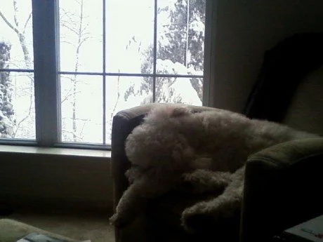
Bunk rests on the chair whilst the snow falls earlier today; after each visit outside to do "business," Bunk returned with snow encrusted into his legs, his undercarriage, even his ears, necessitating 10-15 minutes with the hair dryer...after which he is quite tuckered.

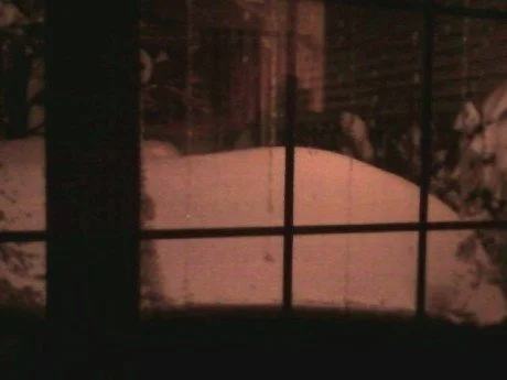
Snow accumulation / driftage at the front door.
A four-foot-high drift / shoveling depository next to our walk; there is a bush under there somewhere.
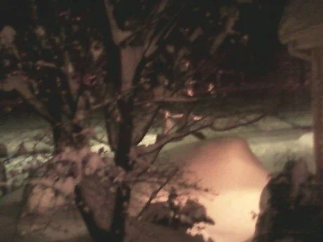
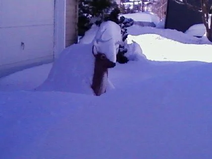
The tree, snow-covered; the concrete deer behind it is completely obscured by the snow.
A five-foot snow pile next to our driveway; in the background is our largely-unplowed road.
Update
on 2010-02-11 18:15 by Monsoon Martin
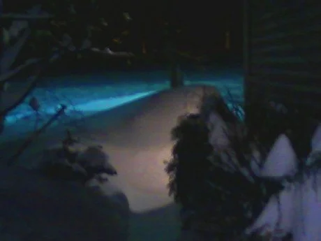
One more pic, taken today from our driveway. No, friends, that's not a photo-negative of Kid from Kid 'N Play rocking the hi-top fade.

That's our deer, buried. In the foreground is a five-foot snow mound that makes the driveway feel like a highway cattle chute.
The roads around northern Lancaster County are pretty bad, and in many places plowing is just beginning. Secondary and more rural roads are especially dicey, as are many parking lots.
Friday school scheduling potentials...
Chance of cancellation for Mifflin (Act 80 Day): 40%
Chance of delay for Mifflin: 20%
Chance of cancellation for the rest of the county (regular school day): 35%
Chance of delay for the rest of the county: 65%
I'm keeping an eye on Monday's storm, and what else lies ahead (there are at least two more storms that could affect us after that)...
Monsoon
Monsoon's Snowbound In-Storm Observations
It’s still snowing heavily here in northern Lancaster County as of 4pm, and my very kind neighbor just made another pass with the snowblower.
We’ve got 16 inches of snow on the ground here and things won’t wrap up until at least 8 or 9pm. The low pressure looks to be stalling off the coast and prolonging the snowfall, so we may actually see widespread totals above 20 inches and even approaching two feet by the end of this event.
Other Pennsylvania storm totals as of mid-afternoon include Mohnton (16 inches), Lititz (17 inches), and Dover (20 inches). [Remember to send me your snow totals and I’ll share them on the weblog.]
Seasonal records for snowfall have been set all over the place. President Obama, who coined a new term (“Snowmageddon”) to describe this past weekend’s event, will have to come up with another one.
Conditions are bad out there, and will continue to deteriorate. Major highways (including 80, 81, 83, 78, and 76) have been closed due to poor road conditions and diminished visibility. The weight of the snow is a danger to those shoveling it; in addition there have been roof collapses and other structural damage reports in Delaware, where more than 50 inches of snow (!) have fallen in the past week.
Winds are also becoming a problem, with reports of 15-20mph winds and higher gusts in the immediate forecast area. Wind speed is expected to reach 20-25mph with gusts near 40mph throughout the evening—look for whiteout conditions, downed trees, and possible power outages.
As it stands, we’ve gotten a mind-boggling three feet of the stuff here in Adamstown since 2/5. Daaaaaamn…
Updated school cancellation/delay projections for tomorrow…
Chance of cancellation, Thursday 2/11/10: 85%.
Chance of delay, Thursday 2/11/10: 30%.
[When will we clean all this up? I don’t think two hours Thursday morning is going to cut it; a cancellation seems pretty likely.]
Wouldn’t it be nice if this storm marked the end of winter? I think even the most snow-rabid among us would admit to some fatigue with the stuff by now. (On a personal note, I love forecasting winter weather, especially with these big, dramatic storms and historic snow totals. But even I’m getting a little tired of this!)
And yet, there’s more.
Monday 2/15 to Tuesday 2/16: snow overnight Monday into Tuesday morning could disrupt school schedules and make travel treacherous once again. This is five days away so it’s difficult to make snowfall projections, but it appears this one will likely be in the range of 6-8 inches.
Saturday 2/20 to Sunday 2/21: another one is setting up for this period, but it is far too early to even take a stab at totals, etc.
No real warm-ups anytime soon, either—highs hovering around freezing for the foreseeable future—so these giant mounds will be with us for a while.
Stay tuned……
Monsoon's call for the Tuesday-Wednesday storm
The Tuesday-Wednesday system is looking impressive. Snow totals will not rival those of this past weekend, but they won't be terribly far behind. (Jeez – could we get a nice, moderate 4-6 inch snowstorm this winter?)
The storm (a bona fide Nor’easter) will actually hit us in two waves. Here’s what to expect. A reminder that timing and snowfall predictions are for Berks and northern Lancaster Counties unless otherwise specified.
Light snow arrives Tuesday by 5 or 6pm. A few inches will accumulate, then there’ll be a lull early Wednesday morning. School administrators should not be deceived by this break, however, into thinking that it’s all over with. Quite the contrary.
The second round of precipitation will crank up around morning rush Wednesday or a bit later and continue right through Wednesday evening rush. From this second round alone we could see 9 inches of accumulation. Snow tapers and ends by Wednesday evening.

The second "round" of the storm, right around midday Wednesday.
But here, my snow-besieged friends, is where it really gets fun. By mid-morning on Wednesday, the northwest winds will crank up, reaching their height (sustained winds in the 20-25mph range, gusting past 40mph) on Wednesday afternoon and evening. What these near-blizzard conditions portend for us is blowing, drifting, extremely poor visibility, and power outages—not to mention wind chills plunging into the lower teens—right when we’re trying to clean up this mess. This wind—plus the dumping of a foot of snow on top of the foot and a half most of us got just a few days ago—may extend delays and cancellations in Thursday.
Accumulation:
It's looking like 12-16 inches for Reading and northern Lancaster County. A bit more toward south-central Pennsylvania in places like Columbia and York—perhaps approaching 20 inches again! Less in north Jersey and the coasts (on the coasts, there could be a mix) and toward the Poconos—4 to 6 inches at most in these areas.
Cancellation/delay potentials:
Tuesday
Early Dismissal 20%
Wednesday
Delay 25%; Cancellation 90%
Thursday
Delay 75%; Cancellation 55%
Whew. Stay tuned, as always, for updates on this extraordinary winter weather!
Monsoon on midweek storm, delay and cancellation projections
Tonight will be extremely cold with lows getting down into the single digits, and temperatures will only be in the teens well through Monday morning rush, so all the meltage from today will be well frozen over. Use caution and see my cancellation/delay predictions below…
Here are some central and southeastern Pennsylvania weekend storm totals per readers:
|
Brookhaven |
26.5” |
|
Adamstown |
20” |
|
Littlestown |
26” |
|
Lancaster |
19” |
|
Kirkwood |
24” |
|
Douglassville |
18” |
|
Norristown |
23” |
|
Sinking Spring |
18” |
|
Nolde Forest |
22.5” |
|
Myerstown |
18” |
|
New Cumberland |
22” |
|
North Wales |
18” |
|
Shillington |
21” |
|
State College |
15” |
|
Upper Merion |
21” |
|
Temple |
11” |
Believe it or not, before we can even catch our collective breath from the walloping we took from the weekend blizzard, another system is poised to affect our area on Tuesday into Wednesday. Here’s the forecast…
Snow develops mid- to late-afternoon Tuesday, light at first. Intensifying by 8pm, then continuing overnight and into late Wednesday afternoon, tapering to scattered snow showers Wednesday evening. (The bulk of the snowfall is early Wednesday morning through early Wednesday afternoon, and watch for high winds on Wednesday as well.)
Though model guidance is not yet in agreement, my call is that we’ll see 8 to 10 inches out of this storm—maybe even a foot. On top of the snow totals from this weekend’s blizzard, that would be positively crippling.
Revised cancellation/delay predictions for the coming week:
Monday 2/8: Cancellation 60%; Delay 85%. (It’s just nasty out there, and lots of roads are still snow-covered. Many families in our districts are dealing with 1 ½ to 2 feet of snow will insufficient resources to deal with the onslaught. Even with the melting that happened today thanks to the brilliant sunshine, frigid temperatures overnight will cause “black ice” on even the clearest of surfaces.)
Tuesday 2/9: Cancellation 10%; Delay 15%; Early dismissal 25%. (The snow will not begin in earnest until Tuesday evening, so I don’t really see that an early dismissal will become necessary. Then again, I didn’t think we at Mifflin would get an early dismissal on Friday, either…)
Wednesday 2/10: Cancellation 85%; Delay 20%. (Unless the timing or storm track change dramatically, a delay just wouldn’t make sense. A cancellation, on the other hand, would.)
Thursday 2/11: Cancellation 40%; Delay 90%. (Wind and temperatures again in the teens overnight into Thursday could lead to a treacherous Thursday-morning commute.)
Friday 2/12: Cancellation 15%; Delay 20%. (It’ll still be cold, but temperatures may inch above freezing. It’s a relief, too, because otherwise Mifflin’s Act 80 full day on Friday would be disrupted…)
Stay tuned for updates/tweakage on this forecast.
Monsoon's Weekend Blizzard Debriefing; Look Ahead to Next Storm
Now that’s what I call a frickin’ snowstorm. My predictions were admittedly conservative, and it turned out that the projected totals were low by as many as six to eight inches in some places. And New York City didn’t get a damned thing.
But wow. Bunk has been traipsing and galumphing through shoulder-deep snow in the backyard and returning to the house with frosty little snow blossoms caked to his coat.
Snow totals, based on my own observations and unofficial reports around the region:
Allentown, extreme northern Berks, and points north, 8-12 inches
Northern Lancaster County, central and southern Berks, 18-20 inches
Philadelphia and immediate suburbs, DC, Baltimore, 24-26 inches; a bit more in some areas
Delaware, northern Maryland, extreme northern Virginia, and extreme southern Pennsylvania, well over 24 inches. Up to 30 inches have been reported in some areas, and there have even been measurements that exceed 2 ½ feet. Boggles the mind.
[Please email me with your storm totals and locations and I’ll post them on my next weblog entry.]
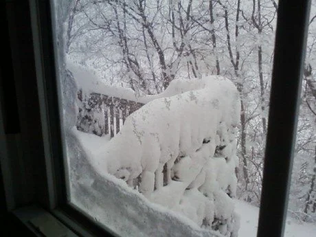
The view out my window toward the deck at 7:30 this morning, before the snow was even finished
Even though the snow has ended across the forecast area by mid-afternoon Saturday, ongoing problems from this storm will be continuing strong winds, which will result in drifting (we have a couple of two-foot drifts here at Monsoon Central), collapsed roofs, downed power lines, and fallen limbs, trees and shrubbery. The temperature will dip into the lower teens tonight, sending the accumulated snowfall into a deep freeze.
Sunday 2/7: partly sunny with moderate winds; high 29, low 11.
Monday 2/8: plenty of sunshine and cold; high 32, low 16.
Tuesday 2/9: cloudy with snow possible (discussed below); high 31, low 25.
Wednesday 2/10: cloudy with considerable winds and lingering snow possible (see below); high 28, low 19.
Thursday 2/11 and Friday 2/12: partly to mostly sunny and milder with highs in the mid 30s and lows in the upper teens.
Saturday 2/13: a bit of snow possible, but nothing like this monster.
A bit of a thaw may be in store by the 20th to the 22nd.
Most forecasters (including this one) have been paying little attention to the Tuesday-Wednesday event, having been preoccupied for some days with this blizzard. But on first blush, here’s my call: the snow begins Tuesday afternoon and continues intermittently through the evening and overnight. Some flurries or snow showers may linger into Wednesday. The snow will not be nearly as heavy as the event that just wrapped up, but I think it’ll leave 4 to 6 inches of accumulation in Berks and northern Lancaster Counties.
All of this—the blizzard, the drifting, the historic storm totals, and the midweek storm—make for a potentially shaky schedule this week. Here are my calls…
Monday 2/8: Cancellation 60%; Delay 80%. (I can see the buses trying to navigate some of the far reaches of my district, unplowed and heavily drifted, and it’s not pretty.)
Tuesday 2/9: Cancellation 30%; Delay 15%; Early Dismissal 40%.
Wednesday 2/10: Cancellation 55%; Delay 75%.
Thursday 2/11: Cancellation 10%; Delay 20%.
As always, stay tuned for updates!
Monsoon's Weekend Snow Update
Arrival looks like 2-3pm (and then it will be light, wet snow that will—since surface temps will be above freezing—melt on contact with the roadway). The real driving hazards will come in the evening when the temperature drops below freezing and black ice develops—and, of course, when the snow intensifies toward 7-8pm. Heaviest snow in our area will fall overnight, from about 12midnight to 4am. Snow is over by about 6 or 7pm Saturday evening.
Considering all that, I’m downgrading the chance of an early school dismissal for the Reading-Lancaster area to 25%. (If we were in Virginia or even Maryland, I think we’d be getting out early.)
A blizzard is defined by the National Weather Service as a storm sustained winds or frequent gusts of at least 35mph, resulting in drifting snow and less than a quarter-mile visibility for more than three hours. We’ll have winds of 15-20mph with gusts up to 30mph overnight and into Saturday morning, so that nearly qualifies. (Places closer to the shores will have actual blizzard conditions due to strong coastal winds.) Visibility will be a problem too.
Projected storm totals:
Delaware, Maryland, Baltimore-D.C. area…20-24 inches.
Philadelphia, southern Chester and Lancaster Counties, central Jersey… 14-18 inches.
Philadelphia’s northern and western suburbs, Reading and Berks, northern Lancaster County, York and Harrisburg…8-12 inches.
Allentown and northern New Jersey, as well as New York City…6 inches.
Poconos and extreme north Jersey…2-4 inches.
Totals may be higher in some spots due to “thundersnow” or heavy bands of precipitation in which 2-3 inches may fall in a single hours. And in any case, depth will be difficult to ascertain given the extensive drifting.
I will send storm updates this weekend as necessary…
Have fun and please—consider staying off the roads for tonight and much of tomorrow if you can. If you must drive, use the utmost caution.
Monsoon's Snowcast for Friday to Saturday
Monsoon’s SnowTable Deluxe
Berks – Lancaster, Friday 2/5/10 to Saturday 2/6/10

Stay tuned this evening or tomorrow morning for updates when and if they're needed...
|
STARTS |
Early afternoon Friday, light snow |
|
ENDS |
Heaviest snow overnight into Saturday morning; tapering by late afternoon Saturday |
|
RATE |
Light to moderate through 7pm Friday; heavy overnight; moderate Saturday morning & afternoon; light through rest of afternoon |
|
DRIVING |
Potentially slippery Friday afternoon through Saturday afternoon; high winds and drifting will reduce visibility on Saturday & Saturday night. Even Sunday morning may be dicey after a refreeze. Bottom line: stay in |
|
MIX |
Maybe a bit at the coasts; for us, there should be no mixing. Expect heavy, wet snow |
|
AMOUNT |
Track has shifted a bit south, but we’ll still see significant accumulation here. The conservative call is 6-10 inches with a bit more possible in isolated areas |
|
ELSEWHERE |
Philadelphia and points south—as well as Chester and southern Lancaster Counties, and places in northern Delaware and Maryland—can expect 14-18 inches of accumulation, and a bit more in isolated spots; central Pennsylvania and points north will receive a bit less than we will in Reading/Lancaster (maybe 4-6 inches) |
|
BUST |
“Bust potential” – the chance we could get little or no snow – is fairly low for this one, but a shift in storm track farther to the south could result in only 5-6 inches |
|
AFTERMATH |
Drifting throughout Saturday and freezing overnight (temperatures will get into the teens) will make things potentially dicey. Temperatures won’t rise above freezing until late next week, so this won’t be going away anytime soon |
|
SCHOOL |
Early dismissal Friday: 40% Delay Monday: 30% |
|
NEXT ONE |
Tuesday night into Wednesday; not a huge storm, but timing could result in school closures |
|
STAY TUNED |
For updates later today and Friday morning when and if my thinking changes |