
Imagine All the Blue Skies...
It’s been too long, my good people, but it’s getting toward the end of the school year, and that means that I find far too much of my time taken up with actual work. It's terribly inconvenient.
The clouds are parting, though (couldn’t resist the weather metaphor), and so I’ve been able to delve back into my love for meteorology.
Expect a Bunk update soon, too.
It’s rainy and cool today, but I’m seeing both bluer-skied and warmer weather straight ahead. Check it.
Tuesday night 5/18: overcast with a leftover shower or bit of drizzle. Low around 50.
Wednesday 5/19: partly cloudy and a bit milder with a slight chance of a passing shower or two early. High 68, low 52.
Thursday 5/20: plenty of sunshine and warmer with gentle breezes. High 80, low 54.
Friday 5/21: sunny, breezy, and pleasant. High 82, low 58. This is Imagine Day at Mifflin, and things are looking gorgeous for an event often beset with unwelcome chilly or rainy conditions.
Saturday 5/22: partly sunny and more humid with a chance of showers or thunderstorms late. High 78, low 61.
Sunday 5/23: partly to mostly cloudy with a couple of showers or thunderstorms moving through. High 76, low 59.
Next week and weekend: highs in the 70s for the first half of next week, with a couple of showers possible on both Tuesday and Wednesday—but neither day will be a washout. We’re looking at a return of warm and humid conditions by Thursday (when highs will be in the 80s). By next weekend (the 29th and 30th of May) we’ll be looking at highs approaching 90 as we enter a period of instability.
Beyond: more seasonable conditions will prevail, with highs in the mid to upper 70s and lows in the 50s. Humidity, instability, and the chance for precipitation return toward the middle of June…
Quick weather update, 12 April 2010
Just wanted to give you all an update on the weather, as we'll see a bit more rain and somewhat more seasonable highs than we've had of late...
Tuesday 4/13: cooler and overcast with a few showers, mainly in the afternoon; clearing late. High 56, low 41.
A weak cold front approaches, bringing with it scattered showers moving in from the northwest throughout the day on Tuesday. Not a washout, but you may want to have an umbrella handy.
Wednesday 4/14: milder with plenty of sunshine. High 64, low 38.
Thursday 4/15: partly cloudy and breezy for much of the day; clouding up late. High 71, low 49.
Friday 4/16: overcast with showers and drizzle possible throughout the day and into the evening. High 66, low 50.
Saturday 4/17 and Sunday 4/18: cooler and generally overcast with rain possible, particularly Saturday. Highs around 60, lows around 40.
Next week: The pattern holds with partly cloudy conditions predominate; highs will be in the lows 60s and lows in the low 40s. Look for a chance of showers on Wednesday 4/21 and Thursday 4/22.
Beyond: Below normal temperatures with highs in the low 50s and temperatures perhaps flirting with the freezing mark here and there. Then, for the end of April: a dramatic warm-up.
Weather Update: 3/30 through next week
Here’s what to expect over the next week or so, weather-wise: rain, then cool, then pleasant, then warm.
In more detail:
Tuesday 3/30: rather windy and noticeably cooler with rain off and on, tapering late. Rain from this evening to Tuesday night could total up to half an inch to three-quarters of an inch in the forecast area. I think areas west of Philadelphia and the immediate suburbs are going to miss the bulk of the heaviest rainfall heading up the coast. High 50, low 42.

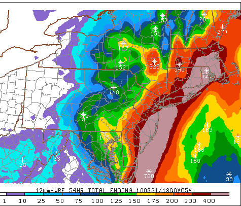
The accumulated rainfall through Wednesday: note that the heaviest amounts (reds and oranges) are along the coast and back into Philadelphia, while we'll see more moderate amounts (greens).
Wednesday 3/31: clearing and winds diminishing throughout the day; becoming milder. High 61, low 38.
Thursday 4/1: sunny, breezy and quite a bit milder. High 74, low 50.
Friday 4/2: sunny and unseasonably warm with mild southwest breezes. High 79, low 54.
Saturday 4/3: sunny and really warm, more than 20 degrees above the normal high for this time of year. I mean, just ridiculous. Really. High 82, low 55.
Sunday 4/4: partly sunny and not quite as warm. High 74, low 52.
Monday 4/5: partly cloudy with a passing shower or two in the morning. High 69, low 46.
The rest of next week: generally partly cloudy with highs hanging in the 60s and lows in the 40s.
Beyond: the following weekend is cooler with highs in the 50s and rain possible.
The Vicissitudes of Spring ... The Majesty of Bunk
Stay tuned after the weather update for brand-new Bunk content!
The weather...

Weather narrative: We’re going to see the fickle vicissitudes of early spring over the next couple of weeks. After today (Sunday) we can bid a fond adieu to the 70-plus temperatures and “spring fever” of the past few days. Monday will bring in a cold front, and with it some rain and plummeting temperatures. Look for the bulk of the rain late Monday afternoon and evening, perhaps lingering into Tuesday morning.
On Wednesday it gets back up into the low 60s, but a stiff wind will make it feel more like autumn than spring. On Friday we get cooler again with showers possible on that day and on Sunday.
Next week (the last week of March) is looking rather cold and rainy, with the possibility of frozen precipitation early on Sunday the 28th and Monday the 29th. This will just be a little dusting or coating – a reminder of what we’re leaving behind, and what we won’t see around these parts again until year’s end.
Beyond the forecast: As we get into what is, for many of us, an abbreviated Spring Break, I’m seeing temperatures rebound into the low to mid 50s (closer to normal for this time of year) with drier conditions generally.
And now, as promised: The Bunk.
I’ve been remiss in providing you updates and pictures of The Bunk here in the New Year; I was a bit preoccupied with the snow, the snow, the snow.
The Bunk is 19 months old now (or he will be, on Wednesday), and remains, believe me, and absolute gentleman. Indeed, to speak feelingly of him, he is the very card or calendar of gentry. [Someone help me: we finished Hamlet a month ago, and yet I cannot stop quoting it. It is not, nor it cannot come to good. See?]
Anywho, he’s a delight. Yesterday he seemed to have finally understood the concept of “fetch” while we mucked about on the tennis courts, but only fleetingly: when he became more interested in a far-off sound, an intriguing smell, or a passing dog, the game was over. He has a formidable bark whose depth and apparent ferocity belie the mildness and poofery of his appearance.
Here are some snapshots of The Bunk being The Bunk, in his own inimitable way.

The Bunk maintains his dignity despite being clad in Christmas-themed garb - Boxing Day 2009

Lounging happily betwixt two pieces of furniture, his body on the chair and his head on the hassock, The Bunk takes both malleability and adorability to new heights - January 2010

DFW: Down for Whatever - January 2010

The Bunk, plastered to my side, some idyllic weekend - February 2010
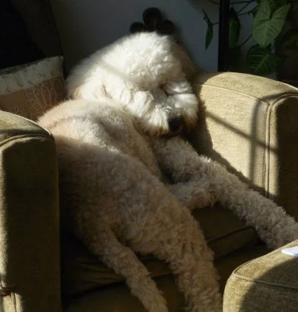
The Bunk breaks his own previous record for malleability, wedged into the chair in the sunbeam, fast asleep - February 2010

Fully splayed, looking like an albino Grover - February 2010

Who's a sleepy boy? You are! You are! - March 2010

The Bunk, at play, yesterday - March 2010
Spring is near.
After what seemed like a solid week of rainy, chilly days, we’re getting a nice reward here with brilliant sunshine and highs in the mid 60s throughout the region. Esbenshades is open, Boehringer’s just opened, and although the spring opening at Shupp’s Grove is a full month away, spring is definitely in the air.
Here’s a look at the weather in store for the last few days of winter and the first week or so of spring…
 Wed 3/17: continued mild with brilliant sunshine as a high pressure system sets up over our area. Look for highs once again in the mid 60s and overnight lows in the mid 30s.
Thu 3/18: sunny and mild once again and somewhat breezy; highs in the mid to upper 60s and a low around 40.
Fri 3/19: sunny and mild again. Look for highs in the upper 60s (some areas could actually reach 70!) and lows again near 40.
Sat 3/20: sunny to partly cloudy and still mild, with highs in the mid to upper 60s and lows in the low to mid 40s. Happy first day of spring!
Sun 3/21: mostly cloudy, breezy and mild with a high again in the low to mid 60s. Slight chance of some showers later on Sunday night, when we should expect a low in the low 40s.
Mon 3/22: sun and clouds mix; cooler with temperatures closer to normal for this time of year (highs in the low 50s, lows in the low 30s).
 Tue 3/23: partly cloudy and seasonably pleasant with highs in the low to mid 50s and lows in the low to mid 30s.
Wed 3/24: partly to mostly cloudy and a bit milder with highs perhaps reaching the upper 50s.
Thu 3/25: clouds arrive ahead of a low pressure system, keeping highs in the low 50s.
Fri 3/26 and Sat 3/27: overcast, rainy and chilly with highs only reaching about the mid 40s.
Sun 3/28 and Mon 3/29: partly sunny and still cool with highs in the upper 40s at best.
Preliminary spring break (or what’s left of it) forecast: looks like the typical early-April pattern holds and we see highs in the upper 40s to low 50s with a few rainy days.
Stay tuned!
Monsoon's Rainy Forecast for Tuesday, 9 March 2010
As the snowy season recedes into memory, and the bulging snow piles shrivel to filthy, pepper-flecked knolls in the far reaches of parking lots, we can look ahead to a rainy mid-March. Here are the details...
Wednesday 3/10: partly cloudy with plenty of sunshine to start; becoming cloudy late. High 58, low 36.
Thursday 3/11: mostly cloudy with rain showers and drizzle developing by late afternoon. Light rain continues on and off into the evening and overnight. Temperatures holding in the low 50s.
Friday 3/12: cloudy and breezy with intermittent rain; becomes heavier at night. Temperatures generally in the mid 50s.
Saturday 3/13: cloudy and windy with steady rain, especially early. Watch for flooding problems developing, particularly at waterways and poor drainage areas. High 58, low 44.
Sunday 3/14: overcast with some lingering showers possible, mainly early, tapering by the afternoon. From Thursday to Sunday most of us will see anywhere from three-quarters of an inch to an inch and a half of rainfall. High 56, low 39.
Next week: seasonably cooler with highs in the upper 40s and lows in the mid to upper 30s. A bit of rain is possible here and there on Monday through Wednesday, but the next steady rain will come through around Thursday 3/18 to Friday 3/19. Cold overnight and early-morning temperatures could result in a few flurries on Friday or Saturday, but nothing accumulating.
Beyond: seasonably cool (or just a tad below normal) into the third week of March, with highs in the mid to upper 40s and lows at or just below freezing.
Snow: there’s a chance, really, until early April. But I truly don’t think so.
Monsoon Anticipates, Answers Your Weather Queries
As the winter comes to a close, I know some of you have questions about the coming weeks, weather-wise. As your faithful blogger, it is my job to not only answer your questions, but to anticipate them.
And so.
What’s this weekend going to be like?
Niiiiiice. Expect plenty of sunshine both Saturday and Sunday with high temperatures approaching (and maybe on Sunday, eclipsing) 50, and a pleasant breeze.
So are we going to get this gargantuan snowstorm, the March 7th 40-incher predicted by Berks almanac-diviner Lester Moyer?
It would appear that we will not…as I said a couple of weeks ago.
What about next week?
Nice again, at least for most of the week. Highs will be in the low 50s on Monday, and the upper 40s through Thursday, with overnight lows just above freezing. Skies will be partly cloudy in general. Expect showers anytime from Friday through Sunday—but these will be rain showers.
And while you’re at it, what’s it going to be like the following week, the 15th through the 19th?
A bit warmer, actually. Highs are going to get into the mid-50s on Monday and Tuesday, then on Wednesday into Thursday we’re looking at chillier conditions and some rain (which may mix with some wet snow at night).
Level with us: is there going to be any more freaking snow?
I really think we may be finished with accumulating snowfall for the season. Seriously.
When can we expect spring-like temperatures?
April? May?
When can I begin wearing my tube-top and culottes out in public again?
Never. Trust me.
If there are any other questions I can answer for you, email me by clicking on the “Monsoon” below!
Monsoon's Snow No More? Forecast
Most places in the area have seen 70+ inches of snow this winter, shattering records, and nearly 50 inches in February alone. (Here in northern Lancaster County we had 46 inches in February.) So…uncle. That’s enough. Ready for the snow to leave us now.
The pattern ahead holds for continued wet weather, but there are signs the arctic air will lift and some milder conditions will move in. Yes, my good people: there is an actual, plausible chance that we may be finished with the snow insanity for winter 2010.
Monday 3/1 – partly to mostly sunny and quite windy, especially in the afternoon. A storm affects New England but not New York, New Jersey, or Pennsylvania. High in the low to mid 40s and low in the upper 20s.
Tuesday 3/2 – plenty of clouds with scattered rain showers in the afternoon and evening. High near 40 and low overnight of around 30. There may be some snow showers and flurries, amounting to no more than a coating. But look out for slick driving and walking surfaces Tuesday night into Wednesday morning.
Wednesday 3/3 – cloudy and breezy with snow showers likely. There is a large coastal storm moving up the coast, but it will miss us to the south. We’ll only see snow showers out of this. [If my thinking changes on this event—which would again mean accumulating snow if it hugs the coast and takes a more northward tack—I’ll let you know.] High in the mid 30s, low in the mid to upper 20s.

Chance of cancellation Wednesday, 15%
Chance of delay Wednesday, 55%
Thursday 3/4 – cloudy and rather breezy with a few stray snow or rain showers possible; clearing and becoming colder later. High in the low 40s, low in the low 20s.
Friday 3/5 – plenty of sunshine with highs in the upper 30s and lows in the mid 20s.
The weekend – sunny and milder with highs in the mid 40s and lows just below freezing. (Note that Sunday is March 7th, the date of Lester Moyer’s Forty-Inch Snow Dump Phantasm.)
Next week – begins with cloudy conditions and highs reaching the upper 40s to near 50 (!). Some rain (all rain, only rain) is possible on Tuesday 3/9 and Wednesday 3/10. By the end of the week, look for seasonably cold temperatures: highs struggling to reach 40.
Next weekend – highs in the 30s, lows in the 20s: colder than normal temperatures, and perhaps some wintry precipitation.
Stay tuned…