
Weekend Update / DWTS Post-Mortem
Let’s get this out of the way: Prince David of Hoffston was the very first participant voted off “Dancing with the Stars” earlier this week. Bad because I would have liked to see him exhibit some more of his stilted gyrations and manic facial expressions—and I think the world is poorer for his going.
Silver linings: the real ballyhoo begins in December with the premiere of his A&E reality show. And his early departure means I never longer have to watch the putrid DWTS again…
Anywho. The weather – it’s a season of change, so I thought I’d give you my latest thinking…
Friday 9/24: sunny to partly cloudy and continued unseasonably hot; somewhat humid. High 93, low 66.
Saturday 9/25: sunny, breezy and pleasant. High 82, low 53.
Sunday 9/26: cooler with periods of clouds and a few passing showers, but not nearly a washout. High 73, low 55.
Next week: rather rainy. Rain Monday, showers and thunderstorms Tuesday, showers on Wednesday. High all three days will be in the mid 70s. Clearing and seasonably cooler on Thursday and Friday with highs just in the upper 60s.
Next weekend: Saturday looks nice; Sunday looks rainy.
Close Encounters and Autumnal Vicissitudes...
Weather-Shieldings,
(Sorry – I’m teaching Beowulf right now and it’s difficult to get it out of my head.)

Last night, went to my favorite movie theater (Penn Cinema, Lititz) for the latest installment in their “Monday Night Movies” series. I’ve written before about this outstanding theater, which features state-of-the-art screens, Digital 3D, and impressive amenities. And construction is nearly complete on a new IMAX theater next door to the main building, slated to open in time for the Harry Potter release on Nov. 19th.
Watching Close Encounters on the big screen reminded me of a time when the movies were about humanity as much as they were about spectacle. The movie was utterly riveting and genuinely breathtaking, but did not contain one explosion, car chase, or murder. And yet, given the lack of those elements, it wasn’t tame or simplistic or cloying, like so much Disney fare. On the contrary, it made powerful statements about who we are, how we want others to see us, and about the power of wonder to cut through even the most entrenched cynicism, the most thickset rationality.
Anywho, last night’s feature was 1977’s
Close Encounters of the Third Kind
The night began with Penn Ketchum (the theater’s owner and namesake) coming out and firing trivia questions at the crowd. The film itself was awe-inspiring: a gorgeous print of a wonderful movie. Richard Dreyfuss’ performance was legendary—nuanced and manic, but never ham-fisted. He won the Academy Award that year for Best Actor, but not for this film; he won for his role in The Goodbye Girl.
The experience reminded me of seeing Poltergeist in the early 80s and being terrified by the scene of the mother trying desperately to get out of a pit dug to accommodate an in-ground pool, clawing at the mud in the pouring rain and sliding again and again back into a nightmarish clutch of skeletons. No one cut off his own foot, there were no meat cleavers to the chest, and no one was disemboweled—and yet it remains one of the most frightening moviegoing experiences of my life. (The creepy clown in that kid's room didn't help matters, either. Yeesh.)
Here’s a full-season list of the Monday Night Movies series. I highly recommend taking the short trip down 222 for one (or more) of these features. (Email me for easy directions.)
9/13 Gone With the Wind
9/20 Close Encounters of the Third Kind
9/27 Kelly’s Heroes
10/4 Titanic
10/11 Jailhouse Rock
10/18 From Here to Eternity
10/25 The Goonies
11/1 The Shining
11/8 Caddyshack
11/15 The Big Lebowski
11/22 Planes, Trains & Automobiles
11/29 True Grit
12/6 Home Alone
12/13 National Lampoon’s Christmas Vacation
So enough about me. How’s the weather?
Weather narrative: The next couple of weeks will feature highs in the 90s and highs that will barely make it into the 60s; that’s what I call a season of vicissitudes. The next few days will be increasingly humid and rather hot, with highs at or near 90 throughout the rest of the week. Watch for isolated thunderstorms on Wednesday afternoon.
The weekend is looking somewhat volatile, weather-wise. Saturday looks like the better of the two days, with the just the chance of some passing showers; Sunday may have more widespread showers. Highs both days will be in the mid 70s, considerably lower than the previous several days.
Next week, after a rainy Monday, we settle in for some weather typical of early autumn: highs in the upper 60s. By the end of next week, highs will struggle to get into the 60s at all.
The following weekend (the first weekend of October) is looking beautiful.
Beyond the forecast: By mid-October, we’ll see highs only in the low to mid 50s and lows dipping into the 30s…
Monsoon's Weather Forecast and Hassel-chat
My good people,
Before I get to the weather, allow me to indulge in a bit of brief Hoff-related chitchat. In point of fact, David Hasselhoff is poised to make a powerful statement about his versatility, his star quality, his ichweissnicht (je ne sais quoi, auf Deutsch) in the coming months.
Just under two weeks ago, The Hoff was “roasted” memorably, if crudely, on Comedy Central.
Beginning in September, he will compete on the upcoming season of “Dancing with the Stars.” (Big ups to Mo and Nicole for scooping even me on this story!) This is a show I’ve never watched, save when Ozomatli performed live on one of the episodes. But rumored participants in this season’s competition, aside from Mikhail Baryshnik-hoff, include Audrina from “The Hills,” The Situation from “Jersey Shore,” Bristol Palin, Octomom, Brandy, and Michael Bolton. (Is it “Dancing with the Stars” or “Dancing with the Has-Beens and Never-Wases”? I mean, aside from The David, of course.) Not to mix metaphors, but that’s what I call an irresistible train wreck of biblical proportions.
And finally, his A&E reality show, elegantly titled “The Hasselhoffs,” premieres in December.

My “live blogging” during the Hoff Roast was a success, so I was thinking of bringing it back for DWTS and/or the A&E show. Thoughts?
Alright, enough of that. It’s time for…
the weather:

Weather narrative: Here at the end of summer (at least for those of us in the education field), the weather has been rather nice: highs in the 70s to low 80s with low humidity. Friday and Saturday should also be quite pleasant, as temperatures will be only moderately above normal and humidity will remain low.
The final heat wave of the summer will begin Sunday, the first of five straight days with high temperatures 90 or above. A relatively low dewpoint and light north and northwest breezes should make things much more tolerable than during other heat waves this summer, when heat indices soared above 100 for days at a time. But still, damned hot.
Things start to moderate toward next weekend, and conditions will be about normal for this time of year.
In terms of tropical storms, Hurricane Danielle is strengthening, but will deal only a glancing blow to Bermuda before heading back out to sea. I’m more interested in Earl, which is currently a tropical storm but looks as though it will intensify into at least a category 3 hurricane. Some models are suggesting that Earl could make landfall along the eastern seaboard, perhaps in our area, around 9/5. Stay tuned for updates.
A return of the heat and humidity will be an unwelcome visitor around the middle of the following week (9/7 and 9/8), but I think that will be short-lived.
Future weather: As we head toward the end of that week (9/9 and 9/10), the humidity will break with some strong thunderstorms and conditions will be drastically cooler. Highs will be in the 70s and lows in the lower 50s.
Winter sneak-peek: There has been a good bit of talk already that we’re going to have a harsh winter. Just today I was talking with Amy about the quantity and girth of acorns on many lawns right about now. As it turns out, extreme heat and humidity during a summer can beget larger and more plentiful acorns, which in turn can be a harbinger of a severe winter. That’s Farmer’s Almanac stuff, there, but there could be some truth in it.
I will, of course, release a comprehensive winter forecast sometime in November. But my preliminary investigation has yielded some sense of what I think we’re in for: late November and December are colder than normal; January thaws; February is frigid; winter temperatures last into March and even early April, with wild fluctuations in between. In terms of wintry precipitation, I don’t see a repeat of the “snowmageddon” of 2009-2010, but a series of smaller snow events, ice storms, and the like, which can be just as dangerous, if not more.
Again, this is a thumbnail sketch; much more detail to come.
I hope everyone has a fantastic 2010-2011 school year!
Monsoon's Weather Report for Thursday, 12 August 2010
Here's the forecast...

Weather narrative: Rain and storms Thursday may linger into Friday, but Saturday 8/14 and Sunday 8/15 look clear with lower humidity. Humidity builds back in late Sunday, though, bringing with it the chance of thunderstorms at almost any time in the first part of next week.
The end of next week will be warmer and more humid still, with temperatures several days flirting with (or perhaps eclipsing) the 90-degree mark. This spell of tropical conditions won’t break until Tuesday 8/24 or Wednesday 8/25.
Future weather: Humidity breaks around mid-week as a strong cold front moves through, bringing with it potentially damaging severe storms. That following weekend (8/28 and 8/29) is looking gorgeous with highs in the low 80s, low humidity, and a nice breeze.
Monsoon’s Heat Wave Alert for Saturday, 3 July 2010
After a few idyllic days with highs in the 70s and pleasant breezes, we’re in for the first real heat wave of the summer: with temperatures reaching into the 90s on Sunday, Monday, Tuesday, Wednesday, Thursday, and Friday. Blech.
Saturday 7/3: Starting out cool; overnight temperatures will be in the 50s around here. Temperatures will climb rapidly in the afternoon, reaching 88. Low 62. And here we go.
Sunday 7/4: Hot, but not yet really disgustingly humid. High 94, low 65.
Monday 7/5: Blazing sunshine with increasing humidity. You'll feel like an hours-old cheeseburger baking under a merciless heat lamp at a rest stop Roy Rogers. High 96, low 69.
Tuesday 7/6: Hazy, hot and humid. Just soupy. Any time you spend outside will feel like you are swimming through a steaming vat of sweat bisque. High 97, low 71. Heat indices in the 100s.
 Wednesday 7/7: Hot, humid, and partly cloudy. By this point you will have forgotten your name, and hallucinations will be common. You’ll move with the leaden, apathetic steps of a high school sophomore walking back to class from the lavatory. Someone will ask, "Hot enough for ya?" and you will stab him in the forehead with your car keys. High 95, low 70. Heat indices again in the 100s.
Thursday 7/8: Blah, blah, yadda, blah. You will get into your car and burn yourself on the seat, the steering wheel, and the gearshift all before you start the damned thing. You'd like to cry out, but the humidity will prevent you from catching your breath, so you just blast the A/C and get on your way. But sadly, you are now delirious and forget where you are going. High 93, low 70.
Friday 7/9: The heat wave breaks as a weak cold front comes through, which may touch off a few thunderstorms. High 91, low 66.
Saturday 7/10: Breathing freely will again be possible. High 85, low 55.
Sunday 7/11: Clouds mixed with sunshine and cooler. High 76, low 53.
The following week: Rainy to begin the week, then a bit warmer with highs in the 80s. By the third week in July, I think we’ll see another heat wave brewing.
Severe Thunderstorms Friday in Berks, northern Lancaster Counties
Looking at a line of severe thunderstorms heading toward the central and southern Berks / northern Lancaster County area. First showers and storms should be in the area around 5pm, then there's a chance of further storms anytime until about 9 or 10pm this evening. Storms could include large hail, damaging winds, and soaking downpours.
Saturday looks hot and humid again (high in the upper 80s) with an even better chance of late afternoon and evening storms.
On Sunday there could be some strong storms in the morning, then skies will be clearing and it will feel noticeably less soupy. High will only get up to around 80.
Next week is looking more seasonable with highs in the 70s and lows in the 50s. Next really good chance for rain is Thursday and Friday.
Next weekend the 12th and 13th, things heat up again. Temperatures will reach or exceed 90 and heat indices will be well into the triple digits.
Stay tuned...
Thursday Thunderstorms: When and Where?
It’s been hot. Soon, it will not. Then, again. Here’s how…
A cold front slams into a hot, humid air mass and brings us thunderstorms that could be damaging. These will develop anytime between 3 and 9pm, and could bring high winds, large hail, and some brief, soaking downpours. Some areas may not see these storms, but most will.
Here’s an extreme example of what it’s like to have baseball-sized hailstones falling from the sky, from an Oklahoma storm about a week ago…
Today will be warm and increasingly humid with thunderstorms possible, as mentioned above. High 88, low 64.
Friday will be partly to mostly cloudy and far more pleasant, with a passing shower or two possible. High 74, low 52.
Saturday looks gorgeous – partly cloudy with a pleasant breeze. High 78, low 56.
Sunday and Monday look warmer still, but not terribly uncomfortable, with highs in the mid 80s. Most importantly for those of you with outdoor plans, I don’t see any chance for precipitation on either of those two days.
The first week of June is looking a little cooler (highs in the 70s) and rainier (especially Thursday and Friday).
Enjoy and be safe!
Monsoon's Forecast for Tuesday, 25 May 2010, featuring the Super-Extended WeatherTable 7013
A new weather forecast, complete with WeatherTable. Hey - you deserve it.
The weather:
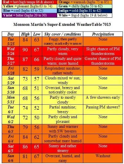

Weather narrative: On Tuesday we’ll see increasing heat and humidity, which will hit us full force on Wednesday. Some thunderstorms will likely move through on Thursday evening, leaving behind more moderate conditions. Right now, it’s looking at though Memorial Day will be chilly with the potential for a few showers, but outdoor plans should be safe for the most part.
Things warm up again toward the end of next week, and then another front comes through next weekend to wash away the mugginess. When that happens, we’ll see some more rain.
Future weather: After a strong cold front comes through, look for moderating temperatures (highs in the low to mid 70s) as we get into the second week of June.
Enjoy!