
Snow Update: overnight freeze?
A week ago, I arrived at school (for an in-service day) to find the stairwell lined with streamers, balloons, and candid shots of me. As I reached the top of the stairs, a row of my colleagues/friends serenaded me by singing "Happy Birthday" whilst wearing David Hasselhoff masks.
These masks--each one, a life-sized head-shot of The Most Hoff fastened to a long wooden skewer--are works of genius. And I decided that I had to incorporate one into my everyday life. So I jammed one into the backseat driver's side window-crevice of my sweet hoopty. See below.
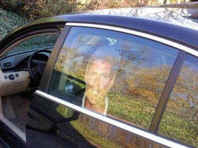

And so it is with this emblem of Hasselhovian magnificence that I make my way about town. And it is just this Hofftastic countenance that I credit with saving my life.
Over the break, I was driving along Perkiomen Avenue when I pulled up at a stoplight behind a car that held a driver and passenger, both of whom appeared to be texting. In fact, the driver's very last concern in the world seemed to be the operation of her vehicle.
It's relevant here to note that these two young women--as I realized later--had a rather rough look about them. They had the kind of hard look that seems to glare out at the world, just daring someone to mess with them.
But again, I didn't realize this until later.
The light turned green, and the car in front of me did not move. A few beats went by, and I sounded an alert with my horn that was intended to be friendly. You know, "Hey there! Hi. Not sure if you had noticed, but the light has changed! Alrighty..." rather than, "Move your ass!"
Apparently, they took it as the latter.
I had overtaken them at some point soon thereafter, and at the next two-lane opportunity, the rode my back bumper hard, then zoomed up alongside me--bent on revenge or mayhem. I think they intended to holler (not holla) at me, or run me off the road, or ram me. Or shoot me. Hoff knows what.
But just then, a funny thing happened: they began laughing merrily, and waved in the most amiable way.
They had seen The Face of The Hoff, and it had tamed them.
So it snowed most of the day, and if I had a nickel for every time a student asked me if we were going to get out early, I'd have my very own authentic K.I.T.T.
We got about what I thought - an inch or two in Berks. Graterford and Skippack picked up a bit over three inches. Elverson and some places in the Poconos were "sweet spots" with four and a half inches. Roads were a bit treacherous this morning--particularly secondary roads, which quickly became snow-covered. Not sure that a delay would have done us any good, and once we were in school, an early dismissal wouldn't have made much sense either.


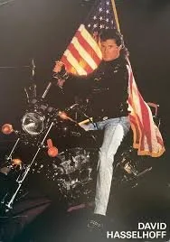
Yes, this is David Hasselhoff dressed as Captain Hook, atop K.I.T.T. And yes, that is David Hasselhoff in the poster over his own right shoulder, photobombing himself. And yes, if you look closely, you can see the photographer in the glare on the hood--all of which makes this photo the perfect example of Hasselicious meta-promotion.Temperatures are expected to get well below freezing tonight (into the mid 20s around here), so the slushy wetness on the roads can freeze into black ice. This slipperyness may persist into early tomorrow morning, but by the time most of us are making our way to work, the sun should dry things out. As a result, I'm only predicting a 20% chance of delay on Wednesday 11/28.
Wednesday turns out mostly sunny but breezy and cold, with a high only in the upper 30s.
Becoming milder toward the weekend - Friday will get into the 40s; Saturday and Sunday will see highs into the mid 50s. Rain is possible on Sunday, and as well through much of new week.
Next really good chance of frozen precipitation for us in December 11th-12th, but that's two weeks away, so let's just relax.
It is a nipping and an eager air.
Horatio's observation came to mind this evening: the air seems much colder than the mid 30s and seems to portend wintry doom.
So what can we expect from this storm?
Temperatures are dropping rapidly, so most of what we'll see will be snow.
(Note: forecast area for this storm includes Lehigh Valley, Berks, Montco, Chester, Bucks, and central/north Jersey. Lancaster, Philly, south Jersey and Delaware will see more mixing and less snow.)
Light snow begins 2-3am and becomes steady for the morning commute. Snow will stick to roads, particularly as surface temperatures remain below freezing and the sun has yet to rise.
Snow mixes with (and briefly changes to) rain in the afternoon as temperatures rise above freezing, then ends as snow in the early evening. Steadiest period of snow will be roughly 6am-12noon. This is a fast-moving storm, so the it will ... well, it will move right on through.
Accumulations: an inch or two generally. We could see a bit more with banding, especially in the higher elevations. Indications are that some areas could see as much as 3-5 inches--but most places, just an inch or two. (Philly and the other areas mentioned get just a coating to an inch of slushy precipitation.)
Delays/cancellations: Considering the two or three (or much more, in Jersey) days we had off for Sandy, I don't see administrators burning a snow day for this pittance. Delay isn't out of the question, since the roads should be less treacherous after sunrise (a couple of minutes after 7am).
Chance of cancellation: 15%
Chance of delay: 35%
Chance of early dismissal Tuesday: 10%
So there you have it.
Blown forecast. I've gotta do a better job.
Obviously, the storm did a heckuva job yesterday.
*ahem*
Stayed east when we thought it would come west. My hat's off to the Nor'easter for giving 110% and really switching it up on us.
*hep-hrrrm*
I mean, we did some nice things in there.
*mmmmmmgch*
The storm did dump snow in some areas, just not where we thought. Freehold had 13 inches, and parts of Connecticut got 8-10 inches.
*sighhhh-cough!*
But I said it was gonna give us some snow, and I take full responsibility for that. All we saw were a few squalls and some wind later on. And that's unacceptable. That's on me.
*claghhh*
Bottom line is, I've gotta do a better job. I've gotta put the forecast models in better positions.
*hack!*
This is fixable. A forecast here and a forecast there, and pretty soon we're back in it.
*ghghghghgm*
We're all in this together. A today we're all gonna be blown: winds will be in the 15-25mph range with gusts as high as 35mph. We'll know more about that tomorrow, since that is when we'll be able to look back and say, this is what happened. Because hindsight's 20/20, and we wanna play aggressive, emotional meteorology.
*mghaaaa*
Nicer weather is ahead. Sunny Friday with a high of 55. Sunny Saturday with a high of 62. Sunny Sunday with a high of 65. And mostly sunny on Monday with a high of 66. Next chance of rain is on Tuesday, so we'll see what happens with that. Thanksgiving week looks like a rainy mess, but we're not gonna get caught looking ahead.
*Hm-uhm...hm-uhm!*
Time's yours.

Nor'easter Snow Update - Wednesday, November 7th
 Alright. So, it looks like snow now. Flurries in the morning, then starting in earnest by noon. Total accumulation 2-4 inches, mainly on grassy areas. This storm has a lot of moisture available to it, and evaporational cooling will produce a column of cold air, giving us more frozen precipitation than we anticipated.
It's wet snow, mixed at times with rain. Temperatures holding steady in the mid 30s; becoming windier throughout the day. Precipitation tapers by Thursday morning's commute.
 Impacts: roads will just be wet, but we could see some slick spots overnight into Thursday morning. In heavier squalls, visibility will be reduced (mainly during the afternoon/evening commute tonight).
Accumulations could be higher in some areas where "banding" (a concentration of heavy precipitation) sets up.
Some widely scattered power outages due to fallen trees (already weakened by Sandy, then finished off with heavy, wet snow) and wind. Winds will increase to 25mph (sustained) with 35-40mph gusts later today.
I'm placing a 60% chance on early dismissal today, and a 30% chance of delayed start tomorrow.
Stay tuned for updates as necessary...
Midweek Nor'easter Update
The Nor'easter is tracking farther east (out to sea) which means a few things for us:
- It will still be windy, but the dangerously high winds (and the ones that could have wrought havoc on already hard-hit areas) will stay out to sea. Winds here will be 15-25mph with gusts of 30-35mph.
- The storm will be weaker, so the worst-case rain totals and flooding should not materialize.
- Only a quarter to two-fifths of an inch of rain will come our way, so the precipitation will be mostly light and intermittent.
- Some forecast models depict accumulating snow with this event, but due to a variety of factors (sun angle, surface temperature, ocean temps, etc.) any snow we see will be wet snow or a mixture, and will accumulate only on grasses. Accumulating snowfall only in higher elevations. Accumulating snow possible (2 to 4 inches) in central and northern NJ and northeast PA, especially on Wednesday evening. Most issues will be in New England.
- I don’t see travel problems (or school delays/closures) with this event.
 Looking ahead...
High in the 50s on Saturday, 60s from Sunday through Tuesday. Partly to mostly sunny throughout, and no rain!
Tuesday 11/13 will have some rain, followed by colder temperatures - breezy with highs only in the 40s...
Midweek Nor'easter comes into sharper focus

The Nor'easter now appears as though it will affect our area, but we will escape the "worst case scenario" event involving extremely high winds and accumulating snow. Here's what I think...
Winds will start to increase on Wednesday morning, and by Wednesday afternoon they will be at 15-20mph (sustained) with 30mph gusts--nothing approaching what we dealt with in the Frankenstorm, but nothing to trifle with, either.
The Hoff reminds you to be sure and vote on November 6th (Democrats) and November 7th (Republicans)!Rain begins to overspread the area by early Wednesday afternoon, with the heaviest rain falling Wednesday evening into Thursday morning. It tapers by Thursday evening. (We could see a bit of wet snow mix in on Wednesday morning and Thursday morning, but it will not accumulate around here. Only higher elevations in the Poconos will see any accumulation.) Total rainfall amounts will be in the half-inch to inch-and-a-quarter range, so we will not see flooding. However, considering the leaning trees, weak roots, and waterlogged ground, even this relatively moderate rain and wind could cause problems.
Highs on Wednesday and Thursday will be 45 and 48, respectively. On Friday, we'll actually see a bit of sunshine (!) and highs getting into the 50s.And Saturday and Sunday look fantastic - highs in the upper 50s/low 60s and plenty of sunshine.
Stay tuned for updates!
...are you ready for the next one?
That's what the checkout person at Home Depot said to me this evening after we had recounted our respective Hurricane Sandy woes. She was talking about the Nor'easter that, rumors says, will strike our area next week with heavy rain and wind--or, in some permutations, snow.
In short: I don't see it.
I mean, the storm is there, but it comes together too late (and too far out to sea) to affect us. Instead, it will likely hit New England with some snow.
The most likely scenario: the Nor'easter skirts our area (just giving us a bit of rain) and stays out to sea, then arrives in New England Wednesday into Thursday.One of the reasons people are latching on to this Nor'easter forecast is that the European model (the "Euro," one of the forecast models), which was one of the first to key in to Sandy's superstorm potential, is depicting a strong storm here. But there are many models--the GFS, NAM, UK, CMC, and others--and none of them can be regarded as a complete forecast. Meteorologists (even amateur ones like me) look at the computer models together with atmospheric trends, weather maps, data, and climatology.
So to sum up: there's a small chance this will hit us. But most indications are that it will miss us, and I feel confident in that forecast.
The weather, then...
Saturday 11/3 will be chilly and breezy with partly sunny skies. High 48, low 32.
Sunday 11/4 looks quite similar: clouds and sun with breezy conditions. High 47, low 30.
Monday 11/5 will be partly sunny and chilly with diminishing and clearing skies toward evening. High 48, low 29.
Tuesday 11/6 will be partly sunny, breezy and chilly (stop me if you've heard this before) with a high of 48 and a low of 31.
Wednesday 11/7 looks cloudy, breezy and chilly with rain. Not a nice day for outdoor activities. High 45, low 38.
Thursday 11/8 will be windy and chillier with partly sunny skies. High 45, low 28.
Friday 11/9 will be sunnier and a bit milder with diminishing winds. High 51, low 35.
Next weekend (the 10th and 11th) will be milder still with more sunshine and highs in the mid 50s.
The following week (beginning with the 12th) will start mild with rain, and end cold with possible snow and ice. (But that's two weeks away, so let's no worry just yet.)

In Hasselhovian news, The Hoff has been spotted recently filming a Dutch advertisement in Portugal, revealed on the television newsmagazine "Access Hollywood" that Carmen Electra was his favorite "Baywatch Babe," and is reportedly mulling a proposal to his Welsh girlfriend Hayley Roberts.
But the big Hasselhoff news is that Herr Fantastisch has deigned to do a Lifetime movie - it's called The Christmas Consultant and features Hoff in the title role as a holiday planner hired by a workaholic wife and mother (Caroline Rhea), but he ends up teaching the whole family important lessons about life and blah blah blah. The draw here is that David will be in full Hammelhoff mode (hamming it up and riffing on his Hoff persona in a self-referential meta-deconstruction worthy of Michel Foucault).
Tune in November 10th at 8pm on Lifetime.
Update on Sandy, Der Frankenstorm
Hey there,
A word about the unofficial name of this event, the Frankenstorm: it originated because the storm is a hybrid of a hurricane, a high pressure ridge, and a cold front, creating a hurricane-Nor'easter hybrid--just as Frankenstein's monster was a maudlin patchwork of humanity. And given that this storm is taking place a couple of days before Halloween, it was bound to resonate. And its Germanic tenor is gold.
(Some outlets like CNN and The Weather Channel have banned any reference to this event as the Frankenstorm, believing that the moniker trivializes a serious and potentially deadly situation. To these fuddy-duddys I say: Get a goddamned sense of humor, will ya?)
So not much has changed regarding the forecast, but some of the timing and particulars have come into clearer focus. Specifically:
We will see some rain from this system Sunday afternoon and evening, but the heavy, lashing rain and whipping winds won't arrive until overnight into early Monday morning.
The entire days on Monday and Tuesday will be just unimaginably shitty. All day Monday and all day Tuesday we can expect sustained winds in the 35-45mph range with gusts reaching 60-70mph (especially on Tuesday). Rain and wind will begin to taper on Tuesday evening and overnight into Wednesday. We could still have a linger shower or three on Wednesday and it'll still be cloudy, but that's it.
The most prominent hazards from this storm will be property damage from flying objects, long-term power outages, storm surges at and near the coasts, and significant flooding.
The governor of New Jersey, the mayor of Philadelphia, and the Berks County Commissioners have declared states of emergency for their areas. Colleges have begun to cancel classes for Monday and Tuesday. I feel confident that our schools will be closed on Monday and Tuesday as well--and maybe beyond, depending on the power outage and downed-tree situations.
Be sure to send me updates at monsoonmartin@gmail.com: storm damage, outages, mewling, and the like. And I'll be sure to send out updates about closures, track, and other particulars as needed (and as possible, depending on the power company).

Stay safe. And also: Hasselhoff.