
It's balls to the wall time!!
Astoundingly, the origin of the phrase cited above has nothing to do with the gonads, though most people who hear it assume it to be a testicular reference. In fact, it originates from aviation: the throttle handles have "balls" on top of them, so when a pilot pushes them to the wall, it's full speed ahead. (There is some disagreement as to its origin, with some positing that the phrase originates from submarining or even railroading. But all are in agreement that the phrase's derivation has nothing to do with the bollocks.)
So, the weather. It's going to get cold. (Well, colder.) Here's what to expect:
Becoming sunnier on Saturday with a windy afternoon. Temperatures will reach the mid 40s, but will feel more like the mid 30s. Same deal on Sunday, with a bit more wind.
 Not literally true. But let's face it: it might as well be.A strong arctic blast moves in on Monday, bringing with it the chance of flurries and snow showers, though I don’t see the potential for measurable accumulation. High Monday 28, low 17. (Wind chills in the low 20s during the day and the low teens overnight. BC3, perhaps reaching BC4.)
Tuesday will be even colder—and brisk, too. High 24, low 15. Wind chills will be in the lower teens (daytime) and about zero (overnight). BC4, perhaps reaching BC5. When it’s BC5, when you say, “It’s cold as balls,” the words freeze into a solid block immediately after leaving your mouth. So don’t even bother.
Wednesday will be partly sunny, breezy and cold. High 26 (wind chill low teens), low 18 (wind chill upper single digits). BC3-4
Thursday looks partly sunny and less windily frigid. High 32, low 22. BC2 in general.
Overcast and quite windy on Friday with highs in the upper 30s and lows in the mid 20s. BC2.
Saturday 1/26/13 brings the next potential of wintry weather. Right now I’d say we’re in for a 6-8 inch snow accumulation, but I will provide updates next week as the event comes into clearer focus. Highs around freezing. BC3-4.
Sunday looks sunny, clear, and colder and strong winds. Highs in the mid 20s (wind chills in the low to mid teens) and lows in the mid teens (wind chills in the upper single digits). BC4.
The following week (January 28th to February 1st) looks promising if you’re starved for winter weather: snow and ice are possible Tuesday the 29th into Thursday the 31st. And maybe something on the following weekend (2/2 and 2/3).
Stay tuned for updates...
Overnight snow / sleet / rain event
My day began in the following manner:
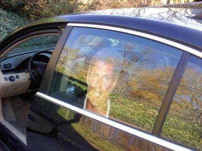
The Hasselhoff head in question. Here it is pictured on the driver's side; I have since moved it to the passenger side because every time Mrs. Monsoon parked to my left in the driveway, she would be startled by the Hoff face staring at her, causing her to utter something like, "Gaaa! God damn it, it's Hasselhoff."I was stopped at the light at 5th and Washington Streets on my way to take The Bunk to day care (don't judge) and then go to work. I had just bade auf wiedersehen to my sweet wife, whose drive to work partially parallels mine.
[I pause here to remind you that my rear passenger side window is adorned with a life-size Hasselhoff head.]
A cab then pulled up alongside me to the right, and the driver rolled down his window, smiling broadly.
"That's the Hoff, huh?"
"You know it!"
"Aw, nice dog, there. [in Bunk's direction:] Mwah!"

"Hahaaauh. Thanks!"
And then he was gone. And my day was made.
So what can we expect from this storm tonight?
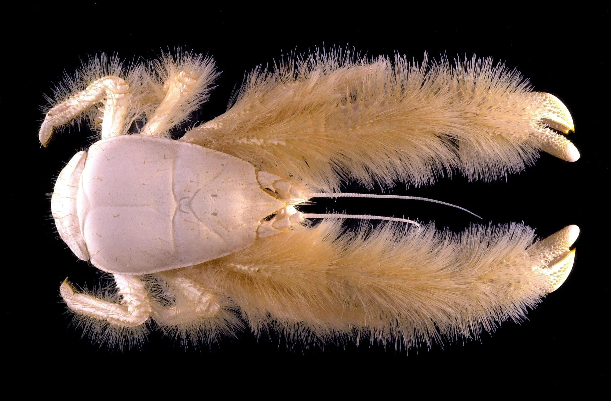
It's the Yeti crab, nicknamed the Hoff Crab by the crew who found it (on account of its evocation of Hasselhoff's hairy chest). It's found in the extreme southern Atlantic. Seriously. The Hoff Crab.Snow and sleet begin by 8 or 9 tonight, continuing and mixing overnight. The extent to which they mix (and the extent to which rain mixes in) depends on your location. In Berks County and points north and east, we're looking at a mostly snow and sleet event. In the immediate suburbs of Philadelphia and points south, it'll be mainly rain. Location will be important with this one.
During tomorrow morning's rush hour it'll still be sleety, but then it mixes with (then changes to) rain, ending by around noon.
Total accumulations of snow and sleet will be in the 1-3 inches range (and likely on the low end of that). Temperatures will hold fairly steady in the low to mid 30s, so we could see some deterioration in travel conditions for the early morning rush.
Probability of delay for Wednesday: 40%
Probability of cancellation for Wednesday: 15%
Stay tuned for updates as they become necessary this evening!
Milder than normal, then normal, then cold, then BC5.
Hi!
I have a forecast for you. If you have not yet done so, please go and "like" my Monsoon Martin facebook page. It's easy, and it's free, and it will help more people enjoy all of this splendor.
Monday 1/14 begins with fog, which will dissipate toward late morning. Temperatures will get into the mid 50s. Maybe a few peeks of sun in the afternoon, but otherwise, overcast and rainy late. We may see a bit of sleet mixed in, but I don’t see any real potential for winter weather. Breezy and turning cold later: low of 34.
Cloudy on Tuesday with a slight chance of snow showers, then rain showers. Generally free of precipitation. High 42, low 30.
 David Hasselhoff, star of stage, screen, and song, rides a tiny motorbike.Wednesday will feature typical January grey, but some periods of sunshine are possible. High 45, low 28.
More of the same on Thursday: high 44, low 25.
Friday will be breezy and sunny with colder temperatures. High 38, low 22.
Next weekend will be overcast with seasonable temperatures. High both days in the low 40s; lows in the low 20s.
Next week begins with colder temperatures, then much colder temperatures. Snow showers (or possibly more) on Monday 1/21; highs in the mid 30s. Highs on Tuesday and Wednesday will only get into the mid 20s, with lows in the teens. We’ll see windy conditions—especially on Tuesday—sending us into BC5 territory for the first time this season. (Protect all your vulnerable bits!)
Next really good chance of snow is Wednesday 1/23 to Thursday 1/24.
We’re getting into a colder pattern here, folks. I know you’ve heard this before, but I shit you not, it’s going to be cold.
January ends cold—and possibly snowy, anywhere in the 1/30-2/1 window.
As always, stay tuned for updates!
I've got a short one for you.
Brief forecast, friends.
Temperatures will be above-normal for about the next 10 days, but the last half of January is colder and potentially snowy.
This week: Plenty of sunshine generally. Highs in the low 40s on Monday, rising to 50 by Thursday. Lows will be in the mid 20s to begin the week; around freezing by Thursday. Pretty windy on Wednesday. Friday looks rainy with temperatures in the mid to upper 40s.
 This weekend: Overcast and mild with some showers likely on Saturday. Highs in the lower 50s, lows around 40.
Next week: Monday the 14th will be overcast, chilly, and rainy. High in the lower 40s. We'll see partly cloudy conditions and similar temperatures on Tuesday and Wednesday. The next really good chance of snow is Thursday the 17th into Friday the 18th. We'll see highs only in the mid 30s on each of those days.
Next weekend: An ice or snow storm is possible on Saturday the 19th. So that'll be fun! Sunday looks clearer and still cold, with highs in the mid 30s.
The rest of the month: Shit gets real. Highs below freezing, lows in the teens, BC4 conditions dominant. Major storm possible on the 24th or 25th.
Stay tuned for updates!
Search queries, CNN, balls-coldness, and January outlook: welcoming 2013!
New Year's revellers!
The end of the year (and a similar exercise on the excellent website Passive-Aggressive Notes) got me thinking about the search queries (on Google, Bing, and other engines) that led people to my weblog. I present some of the most interesting ones here, without comment. (And a special treat, right at the end, from last night's hilariously inappropriate New Year's Eve coverage on CNN.) Please to enjoy:
five guys
many are trapped for hours in darkness and confusion
will it snow on wednesday
eagle’s eye sweaters
rockford files firebird
burger grease paper
unsere freunde book
frere mosoon the wire
blue oyster cult snl
subliminal weed messages
forecastive
frosty pumpkin
hasselhoff berlin wall
monsoon sweatshop
hasselhoff monsoon
hasselhovian
hoffophilia treatment
shakespeare behind bars ksr
armani spade climax
five guys yum
And now, on to the weather.
What to expect in the first two weeks of January…
Tuesday 1/1/13 will be overcast with some afternoon flurries possible. Becoming much colder tonight. High 41, low 22.
Wednesday 1/2 will be, as promised, much colder. In fact, it will set new marks for the season on the balls-coldness meter (apologies to Trevor Wagner for stealing that term). The balls-coldness meter runs as follows:
BC1 = temperatures of 35-40, with wind chills and other atmospheric conditions factored in. (For example, a temperature of 45 with moderate winds would result in wind chills within the BC1 range. A temperature of 36 with no wind would also fall within the BC1 range. Frozen or chilly precipitation can also cause the BC level to drop by a few degrees.)
BC2 = temperatures/conditions/wind chills 25-35.
BC3 = temperatures/conditions/wind chills 15-25.
BC4 = temperatures/conditions/wind chills 0-15.
BC5 = temperatures/conditions/wind chills below zero.
The BC meter does go above BC5, but it's rather self-defeating. Once the temperature sinks under 20 degrees below zero, the testicles instinctively retreat up into the body cavity, rendering the BC scale obsolete. It's science.
So Wednesday will be mostly sunny with moderate winds. Highs below freezing and lows in the upper teens. That places us in the BC3 range.
Thursday will be partly cloudy with light winds, intensifying late. High 35, low 21. (BC2, falling to BC3 in the evening.)
Friday looks sunny and rather windy. High 34, low 21. BC3, falling to BC4 overnight.
Saturday will be similar, but with diminished winds. High 38, low 24. BC1-BC2.
Sunday is the same—in conditions, in temperatures, and in BC levels. So is Monday.
Tuesday 1/8 and Wednesday 1/9 will be a bit milder (highs in the mid 40s) with variable cloudiness and a slight chance of snow/rain. BC1 in the daytime, BC2 at night.
Sunny and windy on Thursday 1/10 with highs in the mid 40s and lows in the mid 20s. (Again, BC1 during the day, BC2 at night.)
Friday 1/11 looks cloudy with some rain showers possible. High 48, low 40. BC1, but BC2 in the evening and in the chilly rain.
Saturday and Sunday will be sunny and chillier. Highs in the upper 30s, lows in the lower 30s. BC1 in the day, BC2 at night.

Monday 1/14 and Tuesday 1/15 look potentially interesting. Temperatures will be in the 30s and some precipitation will be through, so we could see some snow or freezing rain out of this. I will keep an eye on this situation and update you.
Thereafter, it appears that temperatures will rise (highs in the upper 40s), then fall. The second half of January looks to be more precipitation-heavy than the first half of the month. I also expect us to hit BC5 by the end of January, so we have that to look forward to.
Stay tuned for updates, and happy 2013!
Windy today ... and more snow on Saturday?
Let's get right to it.
Partly sunny today and windy: sustained winds as high as high as 25mph with gusts as high as 40mph. High 34, but wind chills will be in the low 20s. Tonight will still be windy (but less so) and temperatures will drop to the mid 20s (with wind chills in the mid teens).
Friday looks partly sunny with increasing cloudiness late; high 38, low 26.
Saturday brings another storm. Snow begins around 7am and begins to taper by about 5pm, ending by about 9pm. Accumulations will be in the 2-4 inches range.
Sunday (and the ensuing 4 days or so) will bring the coldest weather we've seen so far this season. Highs around 33, lows in the upper teens. In fact, the entire first half of January is looking cold in this way.
Next really good chance of snow after this weekend is still January 9-10...

Parade of Storms this week and beyond...
It's the night before the night before Christmas, and things are looking interesting for the coming week and beyond. Here's what to expect in the area...
Monday 12/24: A few snow showers in the afternoon; a coating to an inch of accumulation. Snow mixed with freezing rain tapering to drizzle/flurries overnight. Some places will wake up to a dusting on Christmas morning, which will be delightful. High 40, low 30.
Tuesday 12/25: Overcast with clearing skies late. High 42, low 28.
Wednesday 12/26: Snow, sleet, freezing rain to begin; mixing with, then changing to, rain. Temperatures holding steady in the mid to upper 30s.
Thursday 12/27: Overcast and windy with a few flurries in the morning and afternoon. High 38, low 26.
Friday 12/28: Mostly cloudy with persistent breezy conditions. High 39, low 25.
Saturday 12/29: Snowstorm possible. Highs in the mid 30s. Stay tuned for updates.
Sunday 12/30: Overcast and colder. High 35, low 25.
Monday 12/31: Overcast and still colder. High 33, low 17.
Tuesday 1/1/13: Super cold. High only in the upper 20s. Snowy, too, maybe--lasting into Wednesday the 2nd.
Beyond: Really cold. It's January, after all. Next good chance of a snowstorm is January 9th-10th.
As always, stay tuned for updates...and I hope you all have a safe and relaxing holiday season...

Will it snow Wednesday?
In a few words: it's not likely.
While we are seeing a pattern that is becoming both wetter and colder, I don't see the storm next week coming together in the right way to give us a snow event.
 First, a major honor for stage, screen, and song legend David Hasselhoff. People Magazine's Sexiest Man Alive 2012? No, that title was inexplicably bestowed on wooden-acting douchecake Channing Tatum rather than The Hoff. Time Magazine's Person of the Year 2012? Nah. The readers' poll selected Kim Jong-Un for that distinction; the magazine's choice will be announced on December 19th, but is unlikely to honor the Hoff's immeasurable contributions to humanity. Past winners have included George W. Bush (twice!) and his daddy; Newt Gingrich; The Protestor; and even You.
Perhaps more importantly, Britons named the Christmas Consultant star as the person with whom they'd most like to have a Christmas photo taken.
(Apparently this poll was sponsored by Nikon, and Hasselhoff braved sub-freezing temperatures for a photo shoot that married Baywatch with Yuletide cheer--highlights of which I have sprinkled throughout this forecast.)
 Here's what I think we can expect in the last two weeks of 2012:
Sunday 12/16: cloudy with a brief shower or two this afternoon; foggy tonight. High 54, low 42.
Monday 12/17: a foggy morning; then rainy, mostly in the afternoon and evening. High 52, low 44.
Tuesday 12/18: mostly cloudy and continued mild for this time of year. A shower or two early, then clearing and becoming quite windy. Temperatures dropping throughout the day. High 56, low 34.
Wednesday 12/19: partly to mostly cloudy; breezy and chilly. High 49, low 34.
Thursday 12/20: overcast with breezy conditions. Rain likely, especially later in the day. High 50, low 42.
Friday 12/21: sunny, super-windy, and colder. High of 42 will actually feel 10-15 degrees colder due to the wind. Low 29. (Note: if the world ends on this date, the above forecast is invalid--as are the ones below. I am 96.5% sure the world will not end on this date, however.)
Saturday 12/22: sunny and breezy. High 41, low 30.
Sunday 12/23: breezy and colder; partly cloudy. High 38, low 29.
Monday 12/24: continued cold; partly sunny. High 39, low 33.
Tuesday 12/25: varibly cloudy. Clouding up more as the day goes on. High 43, low 35.
Wednesday 12/26: overcast with rain showers, ending before temperatures drop below freezing. High 50, low 26.
 Thursday 12/27: wintry mix to start, then becoming all rain. (Stay tuned for updates as this event becomes clearer.) High 43, low 31.
Friday 12/28: cloudy, chilly, breezy. High 42, low 30.
Saturday 12/29: cloudy, chilly, breezy. (Stop me if you've heard this before.) High 44, low 33.
Sunday 12/30: cloudy, milder, less breezy. High 49, low 34.
Monday 12/31: cloudy, a bit of rain. High 48, low 32.
Tuesday 1/1/13: cloudy and continued milder. High 50, low 36.
Thereafter: colder, with highs in the mid to upper 30s and lows in the mid to upper 20s. Next chance of frozen precipitation comes in January 5th and 6th...