
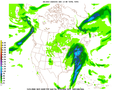
Monsoon's Precipitation Update for Tuesday night, 1 December 2009
Just wanted to alert you to two developing weather stories: heavy rain and wind on Wednesday and possible snow showers this weekend!
Wednesday 12/2 will begin with partly cloudy skies; clouds will increase ahead of a storm front. Expect light to moderate rain to begin by about 2 or 3pm. The rain will intensify (buckets!) throughout the evening and overnight, dropping three-quarters of an inch in most places with an inch or more locally. Watch for flooding in isolated areas. Temperatures will hold rather steady in the neighborhood of 50 for much of the day and evening Wednesday.
Rain will taper into Thursday morning, with a few lingering showers possible into Thursday afternoon. Look for strong winds in excess of 20mph—with gusts exceeding 30mph—overnight and into Thursday morning. Winds will diminish throughout the day on Thursday.
Expect a high into the mid 50s Thursday, followed by a low around freezing as the cold front completes its journey.
Friday 12/4 is looking sunny and cool with a high in the mid 40s and lows into the upper 20s.
On Saturday we could see a few rain and/or snow showers throughout the day, but right now it’s not looking like the moisture is organized enough (nor is the air going to be cold enough) to make this our fifth December 5th snowstorm in the 2000s. Expect highs not above 40 (and falling through the day) and lows Saturday night in the upper 20s. If this becomes anything to get worked up about, I’ll let you guys know.
Sunny, clear and calm for Sunday with a high in the low 40s and a low in the upper 20s.
Next week is looking cool with highs in the mid 40s, and even colder later in the week, when temperatures won’t even get out of the 30s. Look out for a bit of rain on Wednesday 12/9 or Thursday 12/10.
Stay tuned!
Monsoon's Quick Weather Update for Thanksgiving 2009
 Gobble.
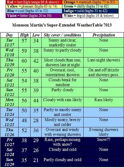
Just wanted to give you a quick update on the holiday weekend weather, as well as what to expect as we head into December…
Tuesday night: Misty and drizzly overnight with a low in the low 40s.
Wednesday 11/25: After a foggy early morning, expect mostly cloudy skies with scattered periods of light rain and drizzle. High 54, low 44.
Thursday 11/26: Clouds mixed with sunshine and a slight chance of an afternoon shower; rain more likely Thursday evening and overnight into Friday. High 58, low 40.
Friday 11/27: Cloudy, chilly and windy with showers throughout the morning and afternoon. Showers tapering at night with clearing overnight. High 44, low 33.
Saturday 11/28: Mostly sunny and very windy, particularly early. Slight chance of some early-morning light snow showers as precipitation moves away; no accumulation to speak of. High 47, low 32.
Sunday 11/29: Partly cloudy and breezy. High 50, low 35.
Monday 11/30: Partly cloudy to start, then clouding up with a chance of rain in the evening. High 53, low 39.
Tuesday 12/1: Overcast and rainy as a cold front moves into the area. Temperatures will dip precipitously at night. High 52, low 27.
The remainder of the week: Noticeably colder with highs only in the mid 40s and lows into the mid 20s.
The following weekend and beyond: Even colder, with highs not even making it out of the 30s for much of this period. The first chance of snowfall appears to be headed into the area around December 7th or 8th…
Have a restful and agreeable Thanksgiving break.
Monsoon's Forecast - including the official Monsoon Martin Winter Weather Outlook® for 2009-2010
After an unseasonably warm weekend, temperatures are going to take a steady nosedive over the next couple of weeks, leading perhaps to our first snowstorm! Temperatures overnight tonight will get into the mid 30s.
Below the WeatherTable and narrative is my Winter Weather Outlook for 2009-2010. Enjoy! Comments and counter-predictions are welcome.
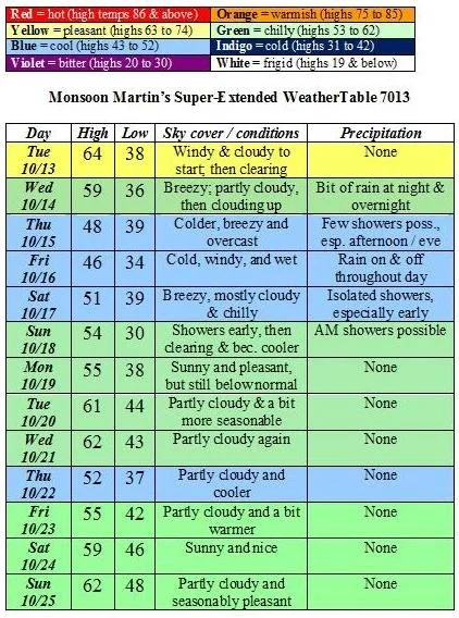
The weather:
Weather narrative: Cooler this week with highs in the mid to upper 50s. Mainly dry with showers and drizzle possible late Thursday and throughout the day Friday. The weekend looks nice: highs in the mid 50s and autumnally crisp.
We’ll begin next week with a bit of rain, after which temperatures will begin to dip – highs will be in the upper 40s to about 50.
The following weekend is looking potentially interesting (note the four-letter word in the WeatherTable) and much colder.
Beyond the forecast: The cold trend will continue into December as highs stay in the mid to upper 30s and lows will continue to dip well into the 20s.
Winter Weather Outlook: And, as promised, here is the official Monsoon Martin Winter Weather Outlook® for 2009-2010. I’ve examined the data, I’ve crunched the numbers, I’ve consulted the models, and I’ve mulled my hunches. Here’s what I came up with…
Over all, I expect that the upcoming winter will be a bit colder than normal, and we’ll have a bit more snowfall than normal. (Snowfall totals for Berks and Lancaster Counties usually average in the range of upper 28” to 34”. Philadelphia and suburbs are usually in the low to mid 20s. This forecast is for Berks and Lancaster Counties only.)
December will begin with colder than normal temperatures and some wet snow by the 2nd week of the month. I think we could also see a small Nor’easter by mid-month. Things dry out for a couple of weeks, but the week between Christmas and New Year’s Day may be snowy. Predicted snowfall: 6”
January will begin with mild and rainy weather, followed by a period of relative pleasantness. By mid-month we’ll see some snowstorms (or ice storms), and they’ll make an appearance at the frigid end of the month too. Predicted snowfall: 12”
February looks bitterly cold, especially the first two weeks. I see a couple of Nor’easter storms this month, either of which could bring blizzard-like conditions and dump in excess of a foot of snow in the region. The month ends, and March begins, with moderating temperatures and rainy weather. Predicted snowfall: 18”
March will bring another smaller storm, and then we’ll see a warm-up by mid-month. This rapid thaw could bring significant flooding in some areas. Predicted snowfall: 4”
The Recap: An active winter lies ahead: temperatures will be a bit below normal with some bitterly cold periods; snowfall will be above normal. Look for snow totals in the vicinity of 40” by the end of the season. I’m predicting 3-4 school cancellations and 5-6 delays this season. Get those scrapers, shovels, and snow-blowers ready!
Quick Weather Update from Monsoon for Wednesday, 21 October 2009
Well. 30s and rainy last Thursday for the Renaissance Faire trip; 70s and sunny tomorrow. Last week I was shivering in the Shire, and today the ladybugs were desperately flinging themselves against my window by the hundreds. Could we have some “average” fall weather (highs in the low 60s and upper 50s; lows in the upper 30s or low 40s, with moderate precipitation)? The answer is yes, by the weekend. Here’s a quick update.
Thursday 10/22: pleasant and unseasonably warm with plenty of sunshine. High 74, low 48.
Friday 10/23: overcast and a bit cooler with showers developing by late afternoon, continuing and becoming heavy at times overnight. High 62, low 54.
Saturday 10/24: cloudy and windy with a shower or thunderstorm early, then clearing, remaining breezy, and cooling off. High 64, low 45.
Sunday 10/25: partly cloudy, seasonably cool and breezy. High 57, low 39.
Monday 10/26: partly cloudy and autumnally appropriate. High 60, low 41.
Tuesday 10/27: more clouds than sun; a few showers. High 62, low 48.
Wednesday 10/28 & Thursday 10/29: partly to mostly cloudy and a bit warmer with some showers possible late Thursday. Highs in the mid to upper 60s; lows in the upper 40s.
Friday 10/30 and Halloween weekend: cloudy, turning colder and perhaps a little rainy on Friday night (high 58, low 36). Clear and colder on Saturday and Sunday, with highs in the mid to upper 40s, and lows in the low 30s.
The first week of November: More of the same. Those of us who haven’t yet seen the first frost will see it this week. As temperatures could dip into the upper 20s at night and there is at least one interesting system moving through, we could see some…no. I dare not speak its name yet.
P.S. Major weather outlets have released (or are preparing to release) their 2009-2010 winter weather outlooks. I am preparing such a package of prognostication and will release it by month’s end.
Monsoon's "Fall or Winter?" Forecast for Tuesday, 13 October 2009
Happy Columbus Day!!
Not. I hate him.
Well, before long folks will be grumbling about the weather skipping autumn altogether and heading right into winter…and if you take a look at the forecast below, you’ll see the grumblers may actually have a point. Average highs for mid-October round here are in the mid 60s; average lows are in the low 40s. Check out what we’re in for…
The weather:
Weather narrative: The weather feels more like late fall than early fall, with temperatures well below normal. A bit of rain is possible every day from Wednesday through Sunday, but I’m seeing a lot of showers and drizzle rather than downpours and washouts, so outdoor plans for those days are still feasible. (The Renaissance Faire trip for students on 10/15 is looking cloudy and cold right now, but should not be spoilt by an abundance of rain.) There have even been some models producing a rain-snow solution for Friday night 10/16 in some outlying areas, but I think that’s highly unlikely to come to fruition.
By the latter part of next weekend, expect clearing and dry conditions with some warming toward seasonable levels by midweek.
Beyond the forecast: The trend for the last week in October is for seasonable conditions (highs in the low 60s, lows in the upper 30s to low 40s) and some more precipitation. I do think the first frost will hold off until the first or second week in November.
Monsoon's Weather Forecast, with WeatherTable
Hey, everyone…
I’ve caught my breath after the beginning-of-the-school-year sprint and thought I’d produce a forecast—complete with the first WeatherTable of the 2009-2010 school year. Weather-friends, I am also looking for suggestions: weather features, forecast tweakage, topic ideas…
The weather:
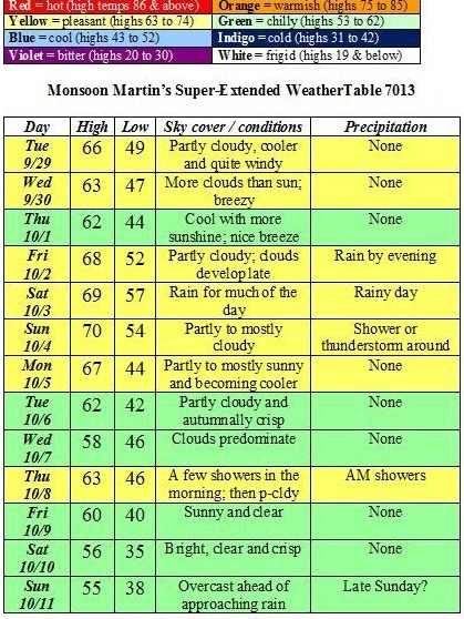
Weather narrative: Fall-like weather is here. Highs will be mainly in the 60s, lows in the 40s. (Toward the end of the forecast, it’s looking like 50s-30s!) Days to be on the lookout for rain include Saturday 10/3 (relative washout), Sunday 10/4 (just a few showers or a storm), and Thursday 10/8 (a few morning showers).
Beyond the forecast: At this point it’s looking like we’ll have a rainy start to the week, with precipitation possible on Monday 10/12 and Tuesday 10/13. Look for temperatures cooler than normal and a bit more precipitation than normal as we head into mid-October…
First Weather Forecast of the 2009-2010 School Year!
...but before we get to the weather, let me offer hearty and enthusiastic birthday wishes to Mallory King, who turns one tomorrow! As the Germans would say, "Alles Gute zum Geburtstag; auf dass den Hasselhoffskraft lächelen über Sie an!" which means, "Best wishes on your birthday; may the power of the Hasselhoff smile upon you!"

Now, onto the weather...
We've been in a dry period of late, and it looks like high pressure will predominate for the foreseeable future here in the region: even when I'm forecasting rain over the next two weeks or so, it's just a sprinkle here and a shower there for the most part. Enjoy...
Mon 9/7 partly sunny, clouding up late; slight chance of a shower or two. High 76 / Low 56
Tue 9/8 more clouds than sun, breezy; perhaps a bit of drizzle or even a shower. High 79 / Low 58
Wed 9/9 breezy, clouds dominate; drizzle or a few showers in the evening or at night. High 74 / Low 62
Thu 9/10 partly to mostly sunny, breezy and cooler; isolated showers late. High 69 / Low 56
Fri 9/11 partly to mostly sunny and pleasant. High 75 / Low 58
Sat 9/12 mostly sunny with patchy clouds. High 78 / Low 60
Sun 9/13 sun mixed with clouds. High 79 / Low 61
Mon 9/14 increasingly cloudy. High 76 / Low 54
Tue 9/15 partly sunny, more humid and cloudy with a few showers in the evening. High 79 / Low 53
Wed 9/16 cloudy with periods of rain; clearing late. High 72 / Low 53
Thu 9/17 mostly clear and pleasant. High 68 / Low 50
Fri 9/18 cooler; sunny and pleasant. High 65 / Low 46
Sat 9/19 sunny, clear, and damn near perfect. High 70 / Low 48
Beyond high temperatures climbing through the 70s for a few days following the forecast period, then seasonably cooler as we head into autumn.
Monsoon Weather Forecast / Farewell to the 2008-09 School Year
Hello out there in weather-land...
Sorry I’ve been incommunicado for some time – it’s the end of a long, long, long-assed school year and I just didn’t have the mojo.
But as I limp toward the finish line and gear up for summer, I can feel the mojo creeping back. Coming attractions over the summer for the Monsoon weblog: my “desert island discs,” reviews, more on The Bunk (who has been sick, but is recovering nicely), the return of the WeatherTable, and much, much more!
And so, I present the final weather forecast of the 2008-09 school year...
Thursday 6/4: Rain tapers throughout the morning following the heavy downpours we saw overnight. Expect occasional showers to develop toward evening, with another round of heavy downpours overnight into Friday. High 66, low 55.
Friday 6/5: Rainy, again, for much of the day. Breezy. Precipitation tapers to showers in the evening, but skies will remain cloudy. High 64, low 52.
Saturday 6/6: Partly cloudy, a bit warmer and quite pleasant. High 77, low 53.
Sunday 6/7: Partly cloudy and warmer, with increasing clouds late. High 82, low 60.
Monday 6/8: Clouds mixed with sun; a shower or thunderstorm possible late. High 84, low 63.
Tuesday 6/9: Cloudy and breezy with a shower or strong thunderstorm possible later in the day or in the evening. High 82, low 64.
Wednesday 6/10: Warm and humid with highs in the mid 80s; a few showers or thunderstorms are likely late. Low in the mid 60s.
Thursday 6/11: Partly sunny and less humid; breezy and much more pleasant. High in the low 70s, low in the mid 50s.
Friday 6/12: Sunny and clear. High in the low to mid 70s, low in the mid to upper 50s.
Next weekend: Overcast with rain possible on Saturday; highs in the mid 70s and lows in the upper 50s.
Beyond: Warming up considerably the following week, possibly getting into the 90s around the 17th or 18th.
Have a great summer!