
Snow potential update: tonight and this weekend
I’ll get right into it.
Tuesday night to Wednesday morning storm: clouds develop throughout the day today; flurries and brief snow showers may appear as early as 5pm. The bulk of the precipitation from about 8 or 9pm tonight through about 5 or 6am tomorrow morning. The snow will generally be light and intermittent, so we shouldn’t expect huge accumulations here: a half-inch to an inch and a half. There may be a bit of slipperiness on the roads, but this is a wetter snow (falling onto a higher-temperature surface) than what we saw last Thursday morning, so many major roads should just be wet. Still, some back roads and untreated surfaces could be dicey.
Possibility of cancellation Wednesday: 10%
Possibility of delay Wednesday: 45%
Friday into Saturday storm: this thing has the potential to be big. A massive area of moisture is poised to affect the region on Friday evening into Saturday morning. A lot will depend on the storm track, but unlike the storm that just grazed Pennsylvania this past weekend, the track sets up somewhat more favorably for us. If it all falls right, we could be looking at a storm comparable in size to December 19th. I’ll keep an eye on it and send updates as this thing comes into clearer focus…
This massive area of moisture has the potential to affect our area with a significant winter storm on Friday into Saturday.
Monsoon's quick update re: February snow potential
Just a few words about the next couple of weeks and what they could bring in terms of wintry precipitation. After all, February is the snowiest month of the year in this area (though in some locales nearby, January edges it out). Here’s what to expect…
Tuesday 2/2 to Wednesday 2/3: I’m looking at a moisture-starved system winging by from Tuesday evening to the Wednesday morning rush hour. Overwhelming evidence suggests that we’ll see just intermittent snow showers and flurries, but there’s a chance we could get a couple inches. I’ll update if I develop any more certainty about what we’re in store for.
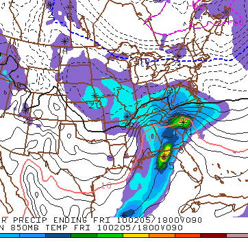
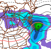
Friday 2/5 to Sunday 2/7: Another round of moisture comes through from the south and west late Friday night through Sunday afternoon. Right now, model guidance is scattered on the track and intensity of the snow we might see. My best educated guess is that we’ll see snow showers on Saturday and Sunday with low accumulations and driving hazards only on Saturday night. Some rain could mix in, particularly as temperatures rise on Sunday.
Sunday 2/14 to Monday 2/15: The middle of February has historically been an active period (think, especially, 2003), and it looks like this year will be no different. There are indications that we could see a blockbuster around this time.
Stay tuned for updates…and as always, thanks for reading!
Monsoon's Forecast and Weekend Storm Update
Light snow showers and flurries early this morning have given us a nice coating on the roads – I have been hearing reports of slipping and skidding, particularly on back roads. Definitely a little more than I anticipated, and we can expect intermittent light snow throughout the morning. Look for the wind to kick up—and may be even a few peeks of sunshine—later this afternoon. Very cold tonight with an overnight low in the mid teens.

As for this weekend’s snow event: we will get nothing. The damned thing is going south, so Pennsylvania and New Jersey will see no snow at all (so Nicole, that child’s first birthday party is on like Donkey Kong!). The Virginias could still see six to eight inches. But again: we’re in the clear, so your weekend plans are safe.
And really, as Melissa pointed out, isn’t weekend snow just a cruel, cruel mockery for a teacher?
Friday will be partly cloudy, windy and markedly colder, with a high only in the mid 20s and a low in the low teens.
Saturday is looking clear and even colder, with a high of 23 and a low of 10 (single-digit lows will appear in isolated areas).
Sunday will still be cold, but not as cold, with the high reaching a balmy 31. We’ll inch above freezing on Monday, and we’ll see highs in the upper 30s throughout the first week of February.
Next winter weather that could impact us: I see nothing on the horizon. Nothing! Does this mean “winter” is over? Not a chance.
Monsoon's Forecast and Weekend Storm Outlook
Whew! That was some storm on Sunday and Monday: more than an inch of rain fell in most places, and the wind wrought havoc, causing downed limbs and power outages all over the place. In the Susquehanna basin, where nearly two inches fell, flood warnings in nearby counties remain in effect until late Wednesday. If this had been snow, some places could have been looking at more than a foot.
Speaking of which…
It’s still 72 hours out from the weekend snow event, but if everything falls right, we could be in for significant snowfall. Here’s my preliminary call, to be updated later this week as more information comes in:
The low tonight will get down into the mid 20s with diminishing winds.
Wednesday will be cooler with plenty of sunshine; the high will struggle to reach 40. Low in the mid 20s.
On Thursday we’ll see similar conditions, but some clouds will move through in the afternoon and evening, which may be accompanied by a passing snow shower. No biggie. High 41, low 20.
Friday will be partly sunny and markedly colder to start; the high will reach only 29. If we do get snow, it will not begin until 5 or 6pm. Right now I’m looking at a period of heavy snow overnight Friday into Saturday afternoon, bookended on Friday evening and Saturday evening by flurries and light snow.
Snow ratios with this storm could be impressive, with the temperature in the teens during the bulk of the storm.
[In brief, snow ratio refers to the amount of liquid precipitation equivalent to the snowfall. For example, with a pretty typical snow ratio of 10:1, ten inches of snow would be produced from roughly one inch of liquid. A “wet” snow has a lower snow ratio; a “dry” or fluffy snow has a higher snow ratio. For this storm, ratios would be in the range of 15:1 or 20:1, and so far model runs suggest that between three-quarters of an inch and one inch of moisture will fall. So, as those of you who are math whizzes have already figured out: that’s in the range of 12 to 20 inches of snow.]
This is all very preliminary, and the models don’t all agree on this solution. The track could be farther south (and some indications suggest this could happen) and give us fairly little, instead whomping the Philadelphia region and points south. The system could fail to tap into sufficient moisture as expected and give us lighter stuff.
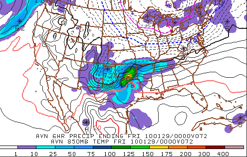
This moisture--which will be centered over Texas and Oklahoma on Thursday night--could give us a significant snowstorm on Friday night into Saturday.
Right now, it’s looking good for fairly heavy, visibility-reducing, plan-cancelling snow on Friday evening, overnight into Saturday afternoon. Best chance right now for us in Berks and northern Lancaster Counties is somewhere in the range of eight inches, maybe ten. (Obviously, given the projected timing, this wouldn't affect school schedules.) Stay tuned for updates!
Sunday Update: Heavy Rain
Just wanted to alert you (at least, those of you who check the site on a weekend) that some heavy rain and windy conditions are in store for us this evening.
Light rain should begin falling by mid-afternoon Sunday, with heavy, soaking rain to fall—more or less nonstop—from 5 or 6pm Sunday evening to mid-morning on Monday. The rain will then taper off through early afternoon.
Temperatures will actually rise overnight with this storm, from the 40s on Sunday evening to the 50s on Monday morning, so we have nothing to worry about in terms of any frozen precipitation.
Some places could get as much as two inches of rain out of this system, so flooding is a concern. We could even have a rumble of thunder or two on Monday morning!

Temperatures will fall a bit throughout the week, and our next best chance of snow is Thursday night into Friday. (Right now, this Thursday-to-Friday event is looking pretty minor, but it bears close watching. Stay tuned for updates.)
Toward next weekend, we’ll see a return to very cold conditions (highs struggling to reach freezing). Looking into February, the next decent chances of wintry precipitation are on the 2nd and the 6th.
UPDATE: Downgrade for tonight's event
I regret to inform you:
Latest model guidance suggests that the precipitation will pass to our south, and that anyone north of Philadelphia will likely get little to no precipitation. Now it appears only Delaware and extreme south Jersey will be affected by this system.
There is still a small chance of a shift in track, giving us (at best) what I forecast yesterday. But I’m going with an across-the-board downgrade...
Chance of closing Friday: 10%
Chance of delay Friday: 25%
Still windy with rain on Sunday evening.
Next best chances for snow: Thursday 1/28, February 2nd through 4th. Stay tuned!
Forecast: Thursday 1/21 - Friday 1/22 Event
People,
Here is my take on the Thursday night-Friday morning event…
The system is not all that well-organized and is not terribly moisture-laden. And there are some forecast models that suggest the system will actually pass to our south, giving us nary a damned thing. But hedge will I not. Here is what I think is going to happen:
Light snow showers develop sometime between 10pm and midnight. Snow showers become somewhat steadier overnight, accumulating perhaps as much as an inch.
Freezing rain and/or sleet mix in toward the morning commute—in the range of 3am to 9am—producing a very slippery half-inch coating of ice on top of the already-fallen snow.
[Quick weather review: freezing rain starts as snow in the upper atmosphere, then melts to liquid form in warmer air closer to the ground. It hits the ground as rain, but when the surface temperature is below 32 degrees, it freezes to the surface, creating a dangerous sheet of ice. On the other hand, sleet also starts as snow in the upper atmosphere, then melts to liquid form, but then refreezes before hitting the ground as ice pellets. Good rule of thumb: if you see it bouncing off the ground, it’s sleet; if it looks like rain but is creating a glazy coating on the ground, it’s freezing rain. They both suck for drivers, but freezing rain tends to be the more dangerous of the two.]
Temperatures will not get above freezing until toward noon, with a high getting to just the mid 30s in the afternoon. Expect tapering precipitation—rain, mixed with a few flurries and snow showers—ending through the afternoon.
We’re in the clear as temperatures get milder on Saturday. Then on Sunday, temperatures will rise into the upper 40s and some heavy rain moves through Sunday evening into Monday. Since the mercury will stay well above freezing, even overnight, this will not cause any driving headaches (other than from those people who seem to have an instantaneous loss of their faculties when driving in the rain), and it will cause no delays or cancellations.
…which brings me to the predictions for Friday.
Chance of school cancellation Friday: 40%
Chance of school delay Friday: 75%
Predictions are subject to change. If my forecast evolves into something significantly different from what appears above (either in time of arrival, or in precipitation types, or in delay chances), I will send out an update.
Weather Update for Saturday, 16 January 2010
Given Friday’s chaotic flavor at Mifflin—45-minute power outage to begin the day, necessitating an altered schedule; unplanned fire alarm halfway through the day, precipitating a trek across the street and another adjusted schedule—folks have been asking me when we can look forward to a snow day in the near future. I regret to inform you that there will be none next week, but I am happy to report that there is hope beyond that.
As far as Sunday’s event, I think we’re looking at all rain there. The rain could be heavy at times, particularly by the late afternoon and through the evening. Rain tapers overnight and could mix with a bit of sleet, but I feel confident this will be insignificant.
Temperatures continue to moderate from the below-normal deep freeze we had prior to this week. Expect highs low 50s today (Saturday) with the low only getting into the low 30s as clouds increase ahead of the storm system.
Sunday 1/17 will be rainy, as previously mentioned, breezy and chilly, with temperatures nearly steady in the mid 30s for the duration of the day.
Monday’s high will be in the mid-40s with mostly clear skies. A system comes through that could give us a coating overnight Tuesday into Wednesday, but it’s more likely that it’ll miss us altogether.
Wednesday 1/20 and Thursday 1/21 will be partly to mostly cloudy with highs in the upper 30s and lows into the low 20s.
Friday 1/22 could bring a little rain (and perhaps mixed precipitation late) ahead of a weak cold front, but again, this is not exactly a blockbuster.
I’m looking at a few potential schedule-changers for those of us charged with molding young minds. Depending on temps and timing, Monday morning the 25th could be just sleety and slippery enough to cause a delay, but not much more. An ice storm brewing around Friday the 29th could give us—dare we dream?—a glorious midwinter three-day weekend.
Beyond that, and into February, the pattern is setting up for another deep freeze and conditions are right for accumulating snowfall, which bodes well for wintry precipitation.
Stay tuned!