
Will Wednesday be snowy or rainy or slushy or sleety?
Yes, it will.
Rumors have been swirling of 6-10 inches or more of snowfall tomorrow. For most of us, I just don't think that will happen. Let me get right into the forecast, which I've been struggling with for a couple of days now...
For those of us in the forecast area (central and southern Berks, northern Lancaster Counties), we'll see snow begin overnight, mixing with rain by late morning. We will likely see several different types of precipitation (snow, sleet, rain) throughout the afternoon and evening before tapering off to flurries and snow showers overnight into Thursday. I believe rain will be the predominant precipitation type most of us will see. Temperatures will hold steady in the mid-30s for the entire day.
Accumulations: An inch or two of snow and sleet accumulation on grassy and untreated surfaces. Extreme northern Berks, Lehigh, and Schuylkill Counties (as well as NE PA, North Jersey, and the Poconos) could see as much as six inches.
Travel problems: Before sunrise tomorrow morning, as well as tomorrow evening, roads could be slick and a bit treacherous. But while the sun is out, most roads will be merely wet.
School scheduling disruptions: Delay 35%; cancellation 15%.
Stay tuned for updates...
Monsoon's Update: cooler weather, mixed precipitation this week?
The temperature got up to 80 in lots of places Friday, but this is still March. Tomorrow may be the first day of spring, but this week (particularly the 2nd half of it) is going to be more evocative of winter...
We'll see a mostly sunny (but less windy) Sunday with a high of 52 and a low of 33.
Rain will begin overnight Sunday into Monday, and it's possible some sleet will mix in during the wee hours (3am-ish), particularly in northern Berks and the Lehigh Valley. No travel issues, no delays, no problem here. Expect rain, mainly in the morning, tapering to scattered showers for the afternoon. High 52, low 41.
Tuesday will feature variable cloudiness and breezy conditions with high of 54 and a low of 30.
More precipitation arrives late Tuesday night (after midnight) into Wednesday morning. The surface temperature may be low enough that snow will mix in early. This wet snow will change quickly to all rain and, once again, will not affect travel or school schedules. High 44, low 35.
Overcast Thursday with perhaps a few showers leftover (and mixed precipitation may be present on Thursday morning; I'll keep my eye on this developing situation). High 46, low 29.
Friday looks partly cloudy, cool and windy. High 42, low 26.
Next weekend looks like another gorgeous one at this point: highs near 50 and plenty of sunshine.
The last few days of March will be milder with highs in the upper 50s and low 60s but (in a preview of the proverbial April showers) rather rainy.
Stay tuned for updates on the potential winter weather this week, but as of now I see no cause for alarm...
Monsoon's NYT letter; Boehringer's rave; weather update
My good blog-readers...
I am pleased to announce that your old pal Monsoon has written a letter to the editor of the New York Times, and it has been accepted for publication in the 13 March edition of the Sunday Magazine. You can check this link and scroll toward the bottom; my entry is headlined "Dislike Button."
My letter was edited for space due to the new format of the Letters page, so here (for you Monsoon completists out there) is the unexpurgated version:
Editor:
I have long enjoyed the Sunday Magazine as the must-read component your increasingly expensive publication. However, the February 27th issue was, for me, a barrage of bad news. I understand that Mr. Lindgren, the Magazine's new editor, felt he had to take steps to remake the glossy in his image, eliminating those columns or features he deemed outdated or redundant. When I read of Deborah Solomon's firing from the Magazine's interview segment, I felt it made sense to rid the magazine of her combative, repetitive, and sometimes misleading pieces.
But the tale that unfolded in the February 27th issue was one of wholesale attrition. First, I read that this column would be Randy Cohen's last as the Ethicist, later learning in an online article that he had already been replaced. Mr. Cohen's elegant, understated responses to ethical quandaries were the first words I read in each edition of the Magazine, and I am already wondering how Sundays will be the same without his work.
Next, I read that this would be the final column for Virginia Heffernan and "The Medium." As the internet becomes an ever more integral part of our lives--my wife and I often ask one another as we look up a recipe or bit of trivia, "What did we do before the internet?"--it would seem that such a column would be indispensible.
Finally, and perhaps most troubling for a high school English teacher and lover of language, was Ben Zimmer's announcement that this would be the final "On Language" column. Mr. Zimmer performed admirably in the unenviable task of replacing the late William Safire in writing this feature. In this time of rapid changes in the development of language--the redefinition of what is acceptable, the spectrum of global influences, and so on--makes a column like this essential.
Mr. Lindgren's apparent policy of taking a scythe to the Magazine in an effort to improve it and make it more relevant seems to me shortsighted and impetuous. It's a classic case of throwing out the baby with the bathwater, and neglects to consider the deeply held loyalties and preferences of your readership.
As you can see, the editors chopped my references to Hugo Lindgren, the Magazine's new editor, while tightening up some of my more longwinded tangents.
It's almost spring, and the March 11th opening of Boehringer's, Route 272 in Adamstown, is a most welcome sign of that season's approach.
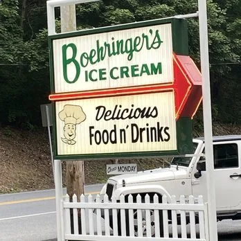
A note about the pronuncation of this throwback drive-in's name: we have been calling it "BOAR-in-jerz" (rhymes with "Four in Purrs") since have been frequenting the joint; most locals say "BERR-ing-ers" (rhymes with "Herr Ringers"); I have even heard it pronounced "BOW-ringers" (rhymes with "Foe Flingers") and "BAY-rin-jerz" (rhymes with "Day Fin Curs").
The German pharmaceutical company Boehringer Ingelheim provides some guidance here: the "oe" construction is an Anglification of the "ö" (o umlaut) in German. The "ö" is difficult for the typical English-speaking mouth to pronounce, but the proper pronunciation is something close to "BAY-rin-gers" (rhymes with Jay Fingers) or "BOH-ring-ers" (rhymes with "Foe Thing Burrs"). Given the tendency of most Pennsylvanians in this region (of German or Penna. Dutch descent) to swallow the "g" in their pronunciations, I'd say either the locals' version ("BERR-ingers") or the second German version ("BOH-ring-ers") is closest. Can anyone shed some light here? Is anyone still reading this?
Well whatever you call the joint, it's fantastic. Boehringer's is celebrating its 75th anniversary this year, and has just created a Facebook presence so you can "Like" them, keep up with goings-on, and generally rave about the place.
Mrs. Monsoon and I went there today for the first time this season. Saw some of my students there (two former, one current) and exchanged pleasantries while waiting for our order. Had my first cheesesteak there (plain, of course). I wasn't expecting Pudge's (the best cheesesteaks in the history of the world; they're in Blue Bell). But I had heard they were good, so I gave it a shot.
My good people, it was damn good. Far better than a cheesesteak from a roadside drive-in has any business being. The roll was good, the cheese was intermingled nicely with the chopped beef, and the overall feeling I departed with was one of pure gustatory pleasure. (Of course, the perfect fries and ice cream cone chaser didn't hurt, either.)
Etiquette is key at Boehringer's: order up at the counter, then step back to wait for your food. The holding open of doors is particularly helpful. Pay with cash only--credit cards and checks are not accepted. Some jackwagon trying to pay for his hot dog, fries, and vanilla milkshake with a platinum card can really gum up the works. Boehringer's is a well-oiled machine, Tucker. Get with the program.
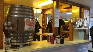
You can't really go wrong at Boehringer's--hot dogs, burgers, steaks, fries, and homemade ice cream. And milkshakes! Oh, the milkshakes. You have to find just the right green-shirted employee, but I have had a few chocolate-peanut butter milkshakes there that made me forget my name.
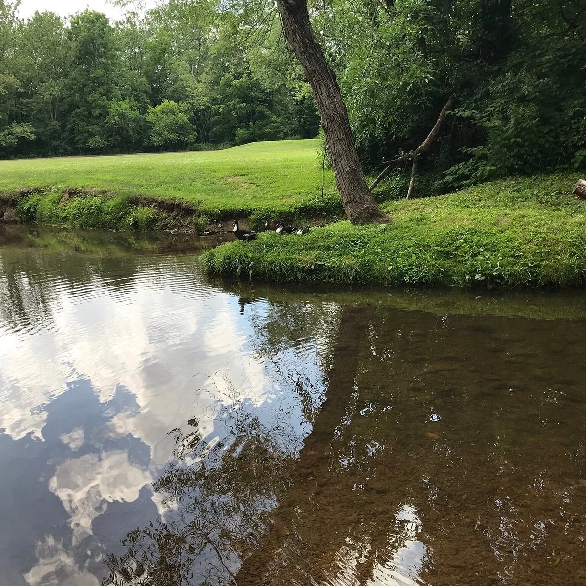
The ambiance is nice, too. Not inside the place--though there is a sort of controlled chaos that I find strangely calming. I'm talking about the creekside picnic tables where you can enjoy your food and watch the ducks pad about. It's like a little park: dogs, fowl, trees, rocks. It's usually quite comfortable and breezy there, even on a really hot and humid day. Sometimes the ants can be a little vexing and the bees a little threatening and the ducks a little aggressive, but what do you want? You're outside and it's lovely. Eat your butter brickle and stop your frickin' complaining.
It's open Tuesday through Sunday, 11am to about 9pm.
I'd love to hear your favorite Boehringer's memories, stories, foods, etc. Email me!
Now on to the weather...
Today was nice - a bit brisk, but plenty sunny. Sitting outside at Boehringer's got a little chilly as highs only reached into the mid 50s.
Sunday will be nice, but a little cooler: mostly sunny and rather windy with highs in the lower 50s (but this high will feel like the lower 40s due to the whipping winds). Low just below freezing Sunday night.
Monday will feature more clouds than sun and highs in the upper 40s. Just light breezes on this day. Overnight lows in the upper 20s.
Tuesday will begin with plenty of sunshine, but clouds will build in late. Expect milder southeasterly breezes to make the mid-50s high feel even a bit warmer.
Wednesday looks rainy and mild with temperatures in the mid 50s for much of the day. We'll see showers and drizzle rather than the soaking downpours of last week.
Thursday and Friday will be sunny and milder still--Thursday's high will be in the upper 50s, Friday's in the low 60s. Maybe an overnight shower Friday into Saturday, but nothing too bad.
Saturday and Sunday look nice: highs in the upper 50s to low 60s, lows in the mid to upper 30s.
Next week looks rainy and cooler. But it will officially be spring! So there's that...
Monsoon's Forecast: watch for flooding Thursday...
First of all: no snow, no sleet, no freezing rain. A different kind of threat looms for the upcoming couple of days - flooding.
Wednesday will be breezy and somewhat cloudy, and increasingly so throughout the day. Look for some drizzle to begin by 5 or 6pm with steadier rain developing after 9 or so. High 49, low 38.
Thursday will be a washout. It's going to rain right through Wednesday overnight into Thursday, and on into the wee hours of Friday morning. The heaviest rain (and greatest chance for flooding) will fall anytime between noon and 8pm Thursday. Highs in the low 50s late Thursday; lows in the low 40s. Expect around 3 inches of rain with this system.

(To give you an idea of how much rain that is: the normal rainfall for the entire month of March is about 3 1/2 inches. And: if this same system hit us about a month ago, when the temperatures were roughly 20 degrees cooler, we'd be looking at two feet of snow, perhaps more.)
On Friday the clouds will linger and a few morning (or even early afternoon) showers could linger too. The winds will kick up, and temperatures will continue to be mild (highs in the low 50s).
Saturday looks just lovely: sunny and breezy with highs reaching into the mid 50s, with lows in the mid 30s at night.
Sunday will be partly sunny and breezy - just a bit cooler with highs reaching into the seasonable upper 40s. Overnight lows right around freezing.
Next week is a mixed bag: look for more of the same (clouds and sun, highs in the upper 40s) for Monday and Tuesday; a bit of rain possible Wednesday and Thursday as temperatures soar well into the 50s and approach 60; clearing and cooler Friday and Saturday with highs again only in the mid to upper 40s.
Update: Monday night - Tuesday morning snowfall
The snow that fell overnight left a coating to an inch in most of the forecast area, but slammed areas much farther north (Scranton, the Poconos, and north Jersey) with more than six inches.
Tonight, however, it looks as though we stand to get some accumulation. The details...
Monday afternoon and early evening will feature scattered rain showers with perhaps a bit of sleet mixed in. This will pose no serious problems.
Expect accumulating snow to develop by 7 or 8pm tonight. The temperature will be falling through the 20s throughout the overnight hours, so all precipitation will be snow. Snow tapers by 5 or 6am and ends altogether by about 8am.
Accumulations are going to vary widely, and potentially present quite a reversal from the normal snowfall scenario.
Philadelphia and the southeastern counties (Delaware, Lancaster, York, Chester) will receive 3-5 inches.
Berks, Bucks, Montgomery, and much of south Jersey will receive 2-4 inches.
(I believe that Berks County in particular will be in the edge of the heavier snow bands; areas in Northern Berks may get only a couple of inches, while southern Berks gets 4 or 5.)
Mercifully, the areas that got bludgeoned last night and this morning (mentioned at the very top of this entry) will see just snow showers and flurries from this system.
School scheduling disruption percentages are for Berks and northern Lancaster Counties only.
Probability of at least a delay on Tuesday, 75%
Probability of cancellation Tuesday, 55%
Stay tuned for updates and tweakage as more information comes in to the ... what should I call it? Send your suggestions about what I should call my weather command center to me by clicking on my sign-off below...
Monsoon's Weather Update: two potentially wintry systems this week...
Sunday 2/20 will start off sunny with an afternoon high in the upper 30s, but clouds will build in ahead of a system that could bring us a return to winter weather. (Those of you who were dangling your bare arms blithely out your open car windows Friday, basking in the unseasonable 70-plus-degree warmth and insisting the winter was over...what say you now, Fussy Britches? I'm guessing you may have been ruing those cavalier words as you fought your way through 30+ mph winds--with gusts into the 50s--yesterday morning and afternoon...)
Anywho, expect light rain to begin by 8 or 9pm Sunday and quickly change over to snow, which will continue off and on overnight and accumulate a coating to an inch at most, primarily on cars and grassy areas. Changing back over to rain by the morning rush (7 or 8am) as surface temperatures rise above freezing. Some icy and slippery conditions are possible overnight and into the morning rush, as I've indicated in the percentages below, but by 9 or 10am Monday the roads will be slushy or just wet.
Probability of delay Monday, 25%
Probability of cancellation Monday, 10%
So. On Monday 2/21, rain tapers to showers and afternoon temperatures will rise to a noticeably milder 45 degrees. Then a second system comes in, starting as light rain in the evening, but quickly changing to snow by around 10pm as temperatures fall precipitously. There is not a whole lot of moisture associated with this system, so expect just a coating to a half-inch of accumulation, again mainly on cars and grassy surfaces. The temperature will stay in the mid-20s (with wind chills in the low teens) through the morning rush, though, so the potential for hazardous driving through this period is a bit elevated.
Probability of delay Tuesday, 35%
Probability of cancellation Tuesday, 15%
Tuesday 2/22 will be breezy and colder, with highs only reaching into the upper 20s and wind chills spending most of the day in the teens.
Wednesday 2/23 and Thursday 2/24 look to be partly cloudy and steadily warmer; Wednesday's high will be in the mid 30s, while Thursday's will be in the mid 40s.
Friday 2/25 looks rainy. Just rain for now as temperatures will be in the mid to upper 40s for much of the day.
Next weekend looks mostly cloudy and a bit windy with highs in the low 40s. A large system packed with a lot of moisture looms for the Sunday 2/27 through Tuesday 3/1 period, but as of now, precipitation type and track are unclear. My best guess is that this is a "miss," but stay tuned. Early March is typically full of wild vicissitudes (particularly in a La Nina winter) and unplesant wintry surprises...
Monsoon's Forecast: Winter isn't finished with us yet...
Temperatures on Friday will reach the mid to upper 60s, challenging record highs in some places. So we’re finished with sub-freezing temperatures, winter weather, and school scheduling disruptions, right?
LOL, my hopeful friends. Your optimism truly has me ROFL.
Anywho.
The answers are no, probably not, and possibly not. I mean, the angle of the sun is changing every day, becoming more direct; and a good deal of the snowpack has melted. But still, those are my answers.
Here are the details:
Friday 2/18: partly cloudy and breezy with strong winds developing Friday evening and overnight. Afternoon high of 66; there is the slight chance of a passing shower in the afternoon. Clearing overnight and markedly colder with a low of 38.
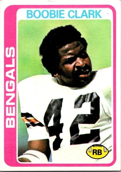
Why do I have a picture of Charles "Boobie" Clark, famed Bethune-Cookman alum and 1970s Cincinnati Bengals running back, on this blog entry? Is his glowering, afroed presence somehow germane to my discussion of the weather? No, my good people. I have invited him here simply because it seemed like the thing to do. Enjoy.
Saturday 2/19: partly to mostly cloudy and really damned windy. The afternoon high of 48 will actually feel more like 32 because of the winds. Winds diminish later; overnight low of 22.
Sunday 2/20: overcast with a chance of rain and drizzle, especially later in the afternoon and in the evening. High 44, low 32. Becoming rather breezy late.
Monday 2/21: cloudy and windy with a bit of rain likely. High 45, low 24. (But wind chills at night and overnight will be in the single digits.)
Tuesday 2/22: a lot depends of track and timing here, but we could get some snow overnight Monday into Tuesday morning. Be sure to check back on Monday (or before, if new information comes to light) for updates, but as of now I’d say you should expect an inch or two of wet snow and minimal travel/school disruptions. I know, you’re all, like, ONNA, but I’m all, TWIS, so GOI.
Whatever the case, it’s going to be windy and colder on Tuesday. Look for overcast skies; high 36 (wind chills in the 20s), low 21 (wind chills in the teens).
Wednesday 2/23: sunny, nice, calmer wind. High 43, low 28.
Thursday 2/24: partly cloudy and cool, but seasonably so (average high for this time of year is 43 or 44 degrees). High 46, low 30. IMHO, this will be the last day for a while that will see below-freezing temperatures. JK! See Friday. And Sunday. And beyond.
Friday 2/25: clouds build in ahead of a system that will affect our area next weekend. Look for warm southeast winds that will usher in warmer air. High 44, low 29.
Next weekend: at this point, it looks like a hot mess. We’ll get up into the upper 50s on a rainy Saturday, then nosedive into the teens overnight into Sunday. People will be, like, OMG, it’s cold! And someone else will be, like, WDYM? It’s still winter! Look for highs barely above freezing on Sunday and Monday, the last two days of February.
Beyond: this system really has my attention. It’s looking like the first two days of March could signal a slam-bang, lead-blanket, charging-rhino type of winter weather event. (I don’t know precisely what I meant by all of those terms, but they sound good and alarming, do they not?)
TTYL,
Update
on 2011-02-18 12:40 by Monsoon Martin
I decided to provide a "key" for my chat/texting abbreviations... I will confess that while writing the post I had to look a few of these up to make sure I was using them properly...
LOL = laugh out loud
ROFL = rolling on the floor laughing
ONNA = oh no, not again
TWIS = that's what I said!
GOI = get over it
IMHO = in my humble opinion
JK = just kidding!
OMG = oh my gosh
WDYM = what do you mean?
TTYL = talk to you later...
Forecast for the two-week period following Monday, 14 February 2011
My good people,
I write to give you only good news about the weather, not to alert you to potential wintry weather headaches and scheduling snafus. Enjoy…
Monday 2/14: quite windy (especially in the evening) with periods of clouds and sun. High 49, but wind chills will be in the 30s. Look for falling temperatures late.
Tuesday 2/15: plenty of sunshine but breezy and colder. High 38, low 22.
Wednesday 2/16: partly sunny and milder. High 48, low 34.
Thursday 2/17: plenty of sunshine and milder still. High 56, low 38.
Friday 2/18: sun with some breaks of clouds and milder still, provoking such comments as, “Spring has sprung!” and “It’s a heatwave!” and “Hot damn – I can finally wear my tube top and Daisy Dukes to the mall!” High 63, low 39.
Next weekend (the 19th and 20th) will be a bit cooler – highs in the low 50s on Saturday (but windy conditions will make it feel cooler) and the low 40s on Sunday.
Next week starts off rainy and cool; some wet snow could mix in overnight into Tuesday as temperatures fall below freezing, but I see only slush (no travel or school disruptions) at this point. But Wednesday 2/23 – when the high looks like it will only just reach the freezing mark – is when we could have a return of some winter weather. Of course, I’ll keep an eye on that and let you know if it’s anything to be concerned about. Right now, I think the overall warming pattern will be too strong to allow this system to do any winter weather damage. Following this storm, we’ll see plenty of sunshine but lingering coldness – highs only in the low to mid 30s on Thursday and Friday.
The following weekend brings the chance of more precipitation, but it looks like things will be warm enough by then to render this wetness in liquid form only.
Stay tuned for updates!