
Monsoon's Quick Update for Friday, 20 February 2009
Today will be cold and rather windy with a high only around freezing and an overnight low of 19. We could see a stray flurry or two this morning.
Saturday will be not quite as cold with partly cloudy skies and a high getting up to 40. Clouds roll in later ahead of a clipper. Light snow begins sometime around 8 or 9 at night and continues off and on until about mid-morning on Sunday. Total accumulations for this weak and widely scattered event will be nothing more than a coating to an inch. (I will send an update if this changes.)
Sunday will begin with a little snow, then turn out partly cloudy and rather windy. High 35, low 21.
Next week is looking breezy and cold to start with highs in the mid 30s and lows around 20. A little milder toward the end of the week with highs creeping into the 40s; rain is possible on Thursday and Friday.
Next weekend looks mild and pleasant with highs in the mid 40s and lows just below freezing.
The next chances for snow are March 2nd-3rd and March 5th-6th as it turns colder and a couple of potential weather-makers roll through, but given our track record with potential storms this winter, I wouldn’t hold your breath...
Have a great weekend!
Monsoon's Weather Update for Wednesday, 18 February 2009
There’s one storm brewing for Monday the 23rd—which could disappoint us, as have many others this winter—but I’m getting the feeling (a full month before the vernal equinox) that the season may be coming to an end. (Am I saying this because the opposite of what I’ve stated has come true so often? A little reverse psychology on Mother Nature? Or do I really believe this? I cannot say.)
Anywho: here’s the weather...
Wednesday – chilly and breezy with snow showers starting by late morning—accumulating not more than a half-inch in most places, and mainly on grassy surfaces—becoming rain showers in the afternoon, tapering late. High 40, low 33.
Thursday – partly to mostly cloudy and windy with a brief snow shower or two possible, particularly in the morning. High 42, low 24.
Friday – colder and quite windy with partly cloudy skies. High 33, low 21.
The weekend – cloudy Saturday with a high in the mid 30s; Sunday will see clouds and sun with a high around freezing and a few snow showers or flurries possible, mainly in the morning.
Monday – overcast with snow possible; stay tuned for updates on this one, which could be an impressive event if it falls right. High 34, low 23.
Tuesday – seasonably milder and partly cloudy. High 38, low 26.
Wednesday – overcast with a bit of rain and/or snow possible. High 36, low 30.
Thursday – rainy. High 46, low 39.
Friday – rainy. High 48, low 36.
Next weekend – partly cloudy and seasonable with highs in the mid 40s and lows at or just below freezing.
Beyond – colder with highs in the 30s and some frozen precipitation possible on Monday the 2nd and/or Tuesday the 3rd.
Nothing Neither Way?
It’s been a season of near-misses, with lots of storms either heading to our north or to our south, and few direct hits. (Actually, shouldn’t the term be “near-hit”? I present this George Carlin monologue to honor his recent passing and celebrate his unassailable logic.)
Here's one they just made up: “near miss.” When two planes almost collide, they call it a “near miss.” It’s a near hit. A collision is a near miss.(WHUMP!)“Look, they nearly missed!” ... “Yes, but ... not quite.”

The storm has taken a turn well to our south, so I don’t even think we’ll see a whole lot of cloud cover—let alone any precipitation—for Valentine’s Day.The next good chances of a snow event are Monday and Thursday.See below for details.
Today will be partly to mostly sunny with those high winds subsiding by late morning or so.High in the mid 40s, low in the low 20s.
Valentine’s Day looks partly cloudy with a high in the low to mid 40s and a low again in the low 20s.
Sunday will bring more of the same: seasonably cool weather and plenty of sunshine with highs in the mid 40s and lows in the mid 20s.
Presidents Day could bring some snow late—though it’s looking increasingly as though that system will also slide to our south.I will let you all know if that changes.For now, let’s call is partly to mostly cloudy and colder with a high of 37 and a low of 20.
Tuesday will be partly to mostly sunny and seasonable: high in the upper 30s, low in the mid 20s.
Wednesday will be mostly cloudy with a chance for sleet and snow, particularly late and overnight into Thursday.High 34, low 28.
Thursday may begin with some snow showers or flurries; remaining cloudy and windy for the day.High 37, low 24.
Friday will see the beginning of a trend toward colder-than-normal conditions: windy with perhaps a lingering snow shower or flurry; a high only in the low 30s, a low in the upper teens.
Next weekend (the 21st and 22nd) is looking interesting weather-wise, particular toward the latter half, which holds the chance for snow and sleet.
Beyond: seasonably cold with highs in the upper 30s to low 40s; lows generally in the mid 20s.Next good chance for snow is Tuesday the 24th.
Monsoon's Forecast for Tuesday, 10 February 2009
I think we’re going into a more active and chillier pattern for the 2nd half of February. Here are the details...
Tuesday night 2/10 – cloudy and mild with overnight lows only in the mid to upper 30s.
Wednesday 2/11 – cloudy and unseasonably mild with showers in the afternoon, the periods of rain in the evening. A thunderstorm may even roll through some places at night. High 64, low 48.
Thursday 2/12 – cooler and very windy with sustained winds in the 20-30mph range; gusts in the 40-50mph range. High 46, low 31.
Friday 2/13 – breezy and partly cloudy with a high of 42 and a low of 23.
Saturday 2/14 – overcast with snow or snow showers possible. Right now I don’t think we’re going to see a whole lot of accumulation from this system, but I’ll keep you posted. High 36, low 24.
Sunday 2/15 – breezy with plenty of sunshine. High 37, low 21.
Monday 2/16 – breezy with plenty of sunshine. High 34, low 20.
Tuesday 2/17 – partly cloudy and seasonably cool. High 36, low 24.
Wednesday 2/18 – overcast with snow possible. High 35, low 27.
Thursday 2/19 – partly cloudy. High 42, low 28.
Friday 2/20 – cloudy with snow possible. High 34, low 22.
Next weekend – partly to mostly cloudy generally with highs in the mid 30s and lows in the low 20s.
Beyond – I’m looking at a possible snow event around the 23rd or 24th.
Monsoon's Weather Update for Thursday, 5 February 2009
After this morning’s reading of 8 at my house (eight!) it’s difficult to believe that we’ll see temperatures in the mid 50s this weekend. But believe it.
Next good chance for snow will have to wait for that mid-month system I’ve been talking about.
Today: plenty of sunshine, but windy and bitterly cold. High 22, low 12.
Friday 2/6: sunny and not as cold. High 35, low 21.
Saturday 2/7: partly to mostly cloudy and milder. High 47, low 33.
Sunday 2/8: windy and unseasonably mild with partly cloudy skies. High 54, low 38.
Monday 2/9: mostly sunny, breezy and cooler. High 42, low 27.
Tuesday 2/10: mostly cloudy with rain developing late. High 44, low 30.
Wednesday 2/11: overcast and breezy with intermittent rain and drizzle. High 45, low 36.
Thursday 2/12: overcast; cooling later with perhaps a rain or snow shower. High 38, low 22.
Friday 2/13: partly cloudy with moderate winds. High 36, low 20.
Next weekend: colder with snow likely the 14th into the 15th. This could be enough to cancel school on Monday the 16th, for those of you who have it. (Mifflin has off.)
Beyond: cold with highs just below freezing and lows in the upper teens; quite windy to begin the week. I’m looking at a system on the 19th and 20th for some possible snow.
Monsoon
"Big" Storm a Bust...
The “triggers” that would have led to a major storm do not appear to be in place, so I think we’re going to be left with an extended period of light to moderate snowfall and flurries from this evening through Tuesday night. Here’s how it plays out:
Monday: a bit of rain develops by mid-afternoon, quickly changing to snow, perhaps giving us a coating by evening commute. Expect a high of 40 in the early afternoon, dropping through the rest of the day. A few snow showers at night and overnight as temperatures dip into the mid 20s.
Tuesday: intermittent snow showers with perhaps a period or two of heavier snowfall, tapering off in the late evening. Snow will generally be light, and will cause relatively insignificant traffic hazards. High 32, low 18.
Wednesday: windy and very cold with increasing sunshine. High 24, low 12.
Beyond: a trend toward moderating temperatures (highs in the 40s, lows at or just below freezing) begins this coming weekend.
Accumulations: fairly light over all. My call is 1-3 inches over the forecast area from Monday evening to Tuesday night.
Delays and cancellations:
Monday early dismissal, 25%
Tuesday delay, 15%
Tuesday cancellation, 30%
Wednesday delay, 20%
Wednesday cancellation, 10%
Stay tuned for updates if anything changes...
Monsoon
We Want the Bunk! Gotta Have that Bunk! (ow)
Habari mori,
The purpose of this post is twofold: to update you regarding my thinking about the potential storm next week, and to update you about the growth of The Bunk.Starting, then, with the most important news of
the two...
Bunk just turned five months old on January 24th and is filling out nicely. He’s every bit the delight he was when he first came into our lives two months ago, and his training continues to go swimmingly. (He’s mastered “sit” and “down” and is working on “stay,” “come,” and “leave it.”)
I thought I’d share some new pictures of Bunk, who now weighs 32 pounds—he was around 22 when we got him—and will apparently not stop growing until sometime this summer!In the first picture, Bunk is happily stretched out on the rug in our bathroom; in the second—an action shot—Bunk is furiously trying to bite the hot air that is being blasted from the hair dryer by his cruel daddy. And the final picture is a close-up of Bunk’s sweet face as he sleeps serenely at the end of the couch.

The Bunk at 5 months

The Bunk at Rest

The Bunk vs. Hair Dryer
An update about the Nor’easter that could affect our weather on Monday and Tuesday: the models continue to be out of agreement, but trends suggest this is going to be a bust.We’re still nearly 48 hours from the event (or at least the part of the event that could be interesting), so a lot can happen between now and then, but here’s what I’m thinking as of now...
Monday will bring rain showers by late afternoon continuing into the overnight hours, with a few snowflakes mixing in.Maybe as much as a coating to a half-inch by Tuesday morning, but nothing to worry about.High 41, low 33.
Tuesday will see some snow showers and increasing wind, but since the low looks to be positioning itself off the coast, the storm will track to the east of what was originally thought, the amount of moisture will be less, the foot-plus snow dump will be averted.High 34 low 18.
Wednesday will see some lingering flurries, high winds, and much colder conditions.High 26, low 14.
The remainder of the week looks sunny, seasonably cold, and dry: highs around freezing and lows in the low 20s.
The weekend looks cloudy and milder with highs in the upper 30s to near 40, and lows just below freezing.
The following week is looking a bit colder; I’m still looking at the 13th and 14th for something interesting...
Monsoon Martin's Complete Weather Forecast for Friday, 30 January 2009
Here's a forecast to give you some idea of the weather we'll be seeing through the middle of February...
The weather...
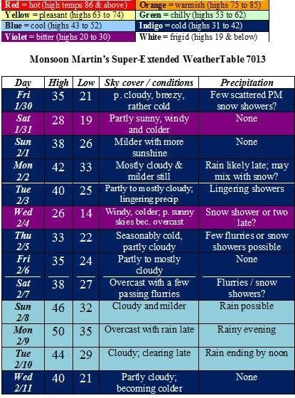
Weather narrative: As far as snowfall is concerned, we may have a few snow showers today, but this is nothing to worry about.There’s a system on Monday into Tuesday that we in the weather community are looking at with some interest, but as of now it looks like mostly or all rain.I will keep you posted if I see anything of concern.
Otherwise, watch out for pretty strong winds on both Saturday 1/31 and Wednesday 2/4.
Beyond the forecast: The following week (beginning with 2/9), we’ll see generally milder weather with highs in the 40s to approaching 50, and plenty of moisture in the beginning of the week; colder temperatures but no snow (or so it appears now) for the remainder of the week.I’m looking at 2/14 and 15 for something interesting in the way of a major storm.