
Monsoon's Forecast for 01.11.10, including WeatherTable
After a few quick flurries and snow showers in places overnight, we’re not likely to see snowfall again until the end of the month. There’s even a warm-up in our near future (hey—the 40s is a warm-up when you’ve been shivering below zero for what seems like weeks). Following a dip into the teens again tonight (Monday into Tuesday), I don’t think we’ll see temperatures below 20 again until month’s end.
Please to enjoy.
The weather:
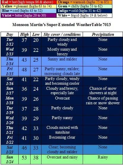
Weather narrative: Gradually milder throughout the week, with highs by Friday approaching 50. There’s a weather system that may impact the area on Sunday into Monday, but it’s looking very good that it will pass well to our south and give us just some flurries and snow showers. (I’ll send an update if my thinking changes on this system.)
Next week will feature temperatures about normal (highs in the 30s, lows in the 20s). The following weekend brings much milder temperatures and some rainy conditions.
Beyond the forecast: The last week of January will see a return to colder temperatures and the potential for more winter weather.
Stay tuned for updates!
Monsoon's Snowcast for Thursday night's event
Sorry I didn’t give a heads-up regarding this morning’s snow showers and flurries. There were some traffic problems (multiple accidents on 222 through southern Berks; a tractor-trailer accident on a ramp of 176) due more to the timing of the snow than to any appreciable accumulation. Might have warranted a delay, but we’re here now, and the snow showers are over for the day.
Many of you have been asking about the Friday event. Over the past weekend, I was thinking the clipper could tap some southern moisture, bringing us as much as 4-6 inches. But it’s looking more like a typical clipper now. Here’s my call:
Light snow begins sometime after 8pm Thursday evening, then continues overnight and through the morning rush, tapering to flurries by 9 or 10am Friday. I expect a coating to an inch for most places, but isolated areas (particularly in areas north and west of Reading) might see as much as two inches.
Probability of cancellation Friday: 30%
Probability of delay Friday: 75%
I will send an update on Thursday if there is any change to my thinking on this event.
Behind this system, we’ll see a return to frigid, far-below-normal conditions, with highs this weekend in the 20s and lows in the teens. The next chances for snow are the 13th-14th (smaller event) and the 18th-19th (more significant event).
Stay tuned for updates!
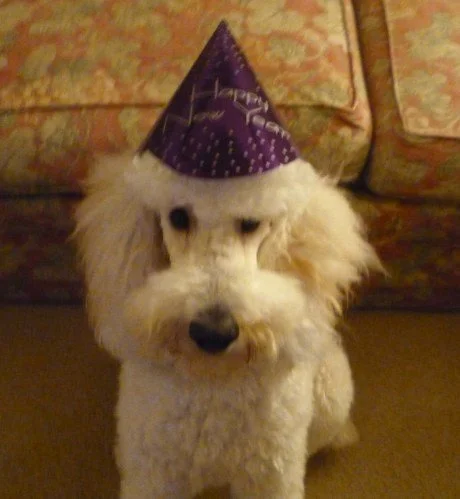
Happy New Year 2010 - Forecast and Bunk greeting
My good people,
After the forecast, I’ve included New Year’s tidings from The Bunk, who wanted to be sure to thank his fans for their love and adoration over this past year or so. (His muzzle is shorn in a poodlishly arresting way to address some matting in the area. But we already know that, whatever the state of his coiffure— puff-out, buzz-cut, mop-top, cornrows, or high-top fade—he is, now and forever, The Bunk. And thanks to Jon and Lori at Total Dog for taking such good care of his coat, even when we don’t.)
Thu 12/31 - after this morning’s snow showers, which gave us two or three inches (and about which I intended to send a forecast update yesterday, but forgot—honest!), we’ll have snow and flurries developing in the evening and continuing overnight, accumulating an additional inch or two. Please be careful driving, as conditions may deteriorate right around when revelry may be at its peak. Low tonight 29.
Fri 1/1 - overcast with widely scattered morning snow showers. Temperatures becoming colder throughout the day with gusty winds, but the precipitation and winds should not cause travel difficulties. High 38, low 25.
Sat 1/2 - partly to mostly cloudy with a slight chance of passing flurries or snow showers throughout the day. Very windy for the duration of the day. High 30, low 17 with single-digit wind chills.
Sun 1/3 - partly cloudy, still quite windy, and even colder. High 28, low 14 with wind chills dipping down toward zero.
The week back to school - highs in the low to mid 30s; lows in the upper teens. Other than a chance of a passing snow shower or two on Monday 1/4, not much this week in the way of winter precipitation.
Next chances for winter weather - things are looking interesting for 1/11 and 1/12, and again on the 14th and 15th. Generally the pattern is setting up nicely for some winter weather in mid-January. Stay tuned!
"We'll take a cup of kindness yet, / for auld lang syne." Happy New Year, y'all!
Monsoon's End-of-the-Year Forecast, Featuring WeatherTable 7013
Yo yo yo,
Well, that Nor’easter really packed a wallop, huh? We had about 10 inches here in northern Lancaster County, a bit less in Reading, and in excess of two feet in some places in and around Philadelphia! Nothing like that in our immediate future, but there are a couple of winter weather potentialities in the forecast…
The weather:
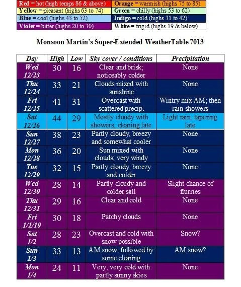
Weather narrative: Pretty quiet until Friday, when Christmas is celebrated. A bit of sleet or freezing rain is possible very early in the morning, but temperatures will rise rather quickly into the mid- and upper-30s, so this will be rain. Look for widely scattered light showers and drizzle for the most part throughout the day, continuing overnight and into Saturday, when Boxing Day is celebrated.
The next few days will be cold, but not damned cold, like it’ll be the second half of the week. If you’re planning on being outside for New Year’s Eve, whether in Times Square for the dropping of the ball or in Dillsburg, PA for the Pickle Drop, temperatures will be in the teens as we herald in 2010, so bundle up!
Speaking of heralding in the New Year, we may see some snow around Saturday the 2nd or Sunday the 3rd…
Beyond the forecast: Frigid conditions will predominate until a mid-month “thaw” during which high temperatures will reach into the 40s and perhaps even the 50s. Reality sets back in later in January, along with the potential for more accumulating snowfall.
Monsoon's December Nor'easter Forecast
Well, well. A December Nor’easter. I’ll be damned.
Long term forecast is in the works, but what you really want to hear about is this weekend’s storm, so here goes…
Snow begins early Saturday morning (perhaps before dawn), rather light at first but intensifying after noon. Heaviest snow will be in the afternoon and through the evening. Snow will taper off overnight, though there’s a chance of a few light snow showers lingering into Sunday morning.
Temperatures will hold in the mid 20s for the entirety of this storm, so there will be no mixing and we’ll get good “fluff” (or snow ratios) here. There are also signs the system will slow down once it gets here, potentially increasing snow totals further. Watch for blowing and drifting as winds kick up in the afternoon and evening on Saturday.
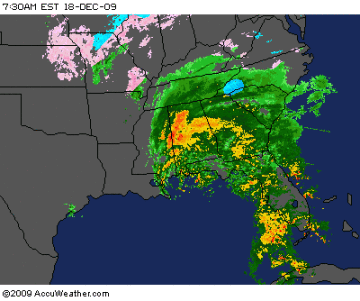
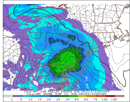
Caveat: storms like this are notoriously difficult to predict, since we’re depending on the low to bomb out off the coast and drive the moisture into our area. A shift of 20-30 miles in track could affect the snow totals—and who gets hit—significantly. Here’s a look at the impressive area of moisture as it churns through the south…
But…no guts, no glory, so I won’t hedge. Here are my predicted storm totals:
Philadelphia and the immediate suburbs, northern Maryland and Delaware, and border areas of south Jersey: 10-14 inches; more in isolated areas
Lancaster, York, and Berks Counties, Lehigh Valley and vicinity: 6-10 inches; more in isolated areas
Lebanon, Dauphin and Cumberland Counties and the central portion of PA: 4-6 inches.
Stay tuned for tweakage and updates as they become necessary…
Monsoon's Winter Precipitation Forecast
Today is friggin’ cold. Any damned fool who has stepped outside can tell that. In fact, it’s going to struggle to get to 30 this afternoon, and given the blustery conditions, wind chills will be in the teens for much of the day. Low tonight: 18.
Saturday looks a bit warmer and still breezy, getting up to a balmy 35, then down to 22 overnight. Mostly sunny skies throughout the day will give way to increasing clouds late.
On Sunday we’ll see light sleet and snow developing by 10am or so, changing first to freezing rain (meaning that it may freeze to surfaces), then changing by early afternoon to plain old rain. The rain will continue through the nighttime, tapering overnight. Expect highs in the low 40s and a low Sunday night in the mid 30s.
Partly sunny and a bit milder on Monday with a high in the mid 40s.
Chance of cancellation Monday: 5%
Chance of delay Monday: 10%
The next chance of winter precipitation is on Tuesday into Wednesday, when a strong cold front and an area of moisture will coincide. But as of now, this doesn’t look like anything to get a jazzed up about.
After that, the next good chance of snow is around the 22nd to the 23rd.
Stay tuned for updates!
Monsoon's Precipitation Update: Tuesday night into Wednesday
A big system with a lot of moisture is headed our way for Tuesday night into Wednesday. Moderating temperatures, however, will mean that a good bit of this will fall as rain, rather than frozen precipitation.
Things get underway after 9pm Tuesday night with some light snow and flurries, as temperatures then will be hovering around freezing. We’ll see temperatures in the 31-34 range from Tuesday night until about 6 or 7 Wednesday morning, meaning there’s a decent chance we’ll see some snow and sleet at the front end of this mess. This could cause a bit of slush and even ice on roads, particularly during early-morning commutes. But by and large, this will be a liquid (not solid, or even semi-solid) affair; I don’t foresee any major delays or problems from this one.
As the morning wears on, temperatures will rise into the low 40s and the rain will get steadier and heavier, washing away any frozen stuff that has fallen overnight (and even what fell over the past weekend). Rain tapers toward late Wednesday afternoon as a very strong cold front moves through.
Temperatures on Wednesday night will reach down into the upper 20s. Highs for the rest of the week will only be in the mid 30s, and windy conditions will produce daytime wind chills in the 20s. (Thursday and Friday nights could even see single-digit wind chills, so watch out.)
More of the same (with a bit less wind) for the coming weekend.
Chance of a two-hour delay on Wednesday 12/9: 30%
Chance of cancellation on Wednesday: 15%
Stay tuned: I will update the situation as needed if my thinking changes on this system.
Monsoon's Snow Alert!® for 4 December 2009
Regarding the Saturday 12/5 snow event: A few of the models are blowing this event up into an eight-incher, but I think we all need to whoa the horsey and take a reasonable look at this thing: it's going to be a fairly glancing blow to our area.
Rain showers and drizzle Saturday early afternoon will quickly turn to snow, tapering toward midnight. High temp around 38 and falling through the afternoon and evening. Accumulations will be widely variable. Some areas could get as much as 3-4 inches; some will just get a coating to an inch. Most places will see an inch or two of accumulated snowfall. In general, places south and west of Philadelphia will see more accumulation than places north and east.
Once the rain changes over to wet snow, it won’t “stick” at first because surface temperatures are so moderate. But cold air aloft will filter down in a hurry, bringing temperatures down and making roads Saturday night potentially slushy and a bit slippery. Use caution.
Becoming sunny and clear Sunday with a high only in the low 40s. Look for sunny conditions and highs in the mid 40s during the first part of next week as well.
Next good chance of snow is around the 15th or 16th.