
Flashback: Monsoon Hasselhoff's "Looking for Freedom" Forecast
My good people...
In the description of this weblog, you have been promised "Forecasting, Minutae, Jibba-Jabba, and Hoffophilia." In the first two years of its existence, there has been a glut of the first three and a regrettable dearth of Hasselhovian content.
That is about to change.
In anticipation of a post currently in the works following the jouncing pecs of The Hoff's life and career, here is one of the first pieces in which I declared my strange love for Sir Chisel of Hairwicke. It's from April 25, 2005 and was disseminated via email, in the old-school fashion, years prior to this weblog's genesis. And it follows below, enhanced with weblinks.
----------------------------------------------------------------------------------------------
Monsoon Hasselhoff’s “Looking for Freedom” Forecast
Monday, 25 April 2005
The entertainment dynamo known simply as The Hoff was born David Michael Hasselhoff born July 17, 1952 in Baltimore, Maryland.
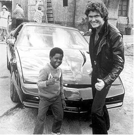
The Greatest Photo Ever Taken; foreground, L to R, Gary Coleman and David Hasselhoff; background, KITT
David Hasselhoff, of course, is a multifaceted, multitalented conquistador of stage, small screen, and song. His distinguished television career has been distinguished (so far) by three unforgettable roles: Dr. Snapper Foster on “The Young and the Restless” in the 1970s; Michael Knight (and a memorable turn as the goateed evil twin Garthe Knight) on “Knight Rider” in the 1980s; and Mitch Buchannon on “Baywatch” in the late 1980s to early 90s (Mitch was also spun off onto the underappreciated early-90s adventure drama “Baywatch Nights,” co-starring Gregalan Williams, Angie Harmon and Lou Rawls).
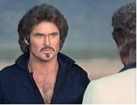
Hoff as Garthe Knight; Garthe once growled: “Michael Knight is a living, breathing insult to my existence.”
His theatre career has recently included roles in the American production of “Jekyll and Hyde” and a leading role in the London production of “Chicago.”
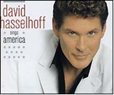
But it is The Hoff’s music career that truly sets him apart as a triple-threat and one of the seminal artists of our time. He busted onto the scene with 1985’s Night Rocker (“I am the night rocker; I wanna rock you in my song.”). He has since released more than a dozen albums in Germany, the only place his true greatness has been acknowledged. The David has achieved the popularity of a Michael Jackson or Tom Jones in Germany. Most recently he released David Hasselhoff Sings America in 2004 and The Night Before Christmas this past November.
From “Flying on the Wings of Tenderness”:
We’re flying on the wings of tenderness
Riding the rivers of gentleness
Into the garden of love we’ll flow and watch it grow together
We’ll build a castle out of honesty
Fill every room with the harmony
Seeing the world trough each other’s eyes
We’ll live our lives together…
In 1994 His Hoffness decided to make a run at the musical stardom that had so eluded him in his homeland. He released a self-titled American “debut” album and hooked up a sweet Pay-Per-View star-studded concert event.

Based on eyewitness accounts (and the opinion of the Hoff himself), he rocked. I mean—he rocked the house like the house had not theretofore been rocked. He left the stage, though, and members of his management team inexplicably wore long faces. “What gives? I rocked it hard,” intoned the breathless David, who had truly “left it all onstage.” It was then that he saw a television—tuned to the live O.J. Simpson white bronco chase. Alas, while the hirsute Hoffmeister was delivering a mind-blowing concert to signal his triumphant emergence onto the American music stage, America was watching a slow-speed chase that would kick off the “trial of the century”—and not his performance. Ach!
His Bemulleted Grace played “Looking for Freedom” at Berlin Wall, New Year’s Eve 1989, to celebrate its crumbling. Hasselhoff himself feels his popularity in Germany was instrumental in bringing down the Berlin Wall and ending the Cold War: “I find it a bit sad that there is no photo of my hanging on the walls in the Berlin Museum at Checkpoint Charlie.”
It was rumored that he was going to release a rap album with Ice-T, but these rumors, tantalizing though they were, proved to be false.
The Hoff once gushed about one of his wildly popular projects: “Beyond its entertainment value, ‘Baywatch’ has enriched and, in many cases, helped save lives. I'm looking forward to the opportunity to continue with a project which has had such a significance for so many.”
On a similar note, commenting on the monumental impact his worldwide stardom—nay, superstardom—has had on children: “There are many dying children out there whose last wish is to meet me.”
Regarding his cameo in the film Spongebob Squarepants: “I've gone from talking to a car to swimming with Pamela Anderson to starring with a sponge.” The David also had a cameo in the film Dodgeball as a German soccer coach.
And finally, in the following oft-repeated quote, The Buff One manages to cram an astounding four clichés into one statement: “Keep smiling! Believe in yourself and never give up; dreams will come true.” And indeed they have: In 1996, His Hairiness received a star on Hollywood’s Walk of Fame.
One of Der Hoff’s most well-known and finely-crafted songs is the German language “Du”—a portion of which I have included (and translated) here for you all:
Du bist alles, was ich habe auf der welt,
Du bist alles, was ich will.
Du, du allein kannst mich versteh’n,
Du, du darfst nie mehr von mir geh’n.
Du, ich will dir etwas sagen
Was ich noch zu keinem anderen mädchen gesagt habe,
Ich hab’ dich lieb, ja ich hab’ dich lieb
Und ich will dich immer lieb haben
Immer, immer nur dich.
*******************************
You are all I have in this world,
You are all I want.
You! You alone can understand me,
You! You may never go away from me.
You…I will say something to you
That I have said to no other girl,
I love you; yes, I love you
And I will always love you
Always, always for only you.
-------------------------------------------------------------------------------------------
Monsoon's Forecast and Weekend Storm Update
Light snow showers and flurries early this morning have given us a nice coating on the roads – I have been hearing reports of slipping and skidding, particularly on back roads. Definitely a little more than I anticipated, and we can expect intermittent light snow throughout the morning. Look for the wind to kick up—and may be even a few peeks of sunshine—later this afternoon. Very cold tonight with an overnight low in the mid teens.

As for this weekend’s snow event: we will get nothing. The damned thing is going south, so Pennsylvania and New Jersey will see no snow at all (so Nicole, that child’s first birthday party is on like Donkey Kong!). The Virginias could still see six to eight inches. But again: we’re in the clear, so your weekend plans are safe.
And really, as Melissa pointed out, isn’t weekend snow just a cruel, cruel mockery for a teacher?
Friday will be partly cloudy, windy and markedly colder, with a high only in the mid 20s and a low in the low teens.
Saturday is looking clear and even colder, with a high of 23 and a low of 10 (single-digit lows will appear in isolated areas).
Sunday will still be cold, but not as cold, with the high reaching a balmy 31. We’ll inch above freezing on Monday, and we’ll see highs in the upper 30s throughout the first week of February.
Next winter weather that could impact us: I see nothing on the horizon. Nothing! Does this mean “winter” is over? Not a chance.
Monsoon's Forecast and Weekend Storm Outlook
Whew! That was some storm on Sunday and Monday: more than an inch of rain fell in most places, and the wind wrought havoc, causing downed limbs and power outages all over the place. In the Susquehanna basin, where nearly two inches fell, flood warnings in nearby counties remain in effect until late Wednesday. If this had been snow, some places could have been looking at more than a foot.
Speaking of which…
It’s still 72 hours out from the weekend snow event, but if everything falls right, we could be in for significant snowfall. Here’s my preliminary call, to be updated later this week as more information comes in:
The low tonight will get down into the mid 20s with diminishing winds.
Wednesday will be cooler with plenty of sunshine; the high will struggle to reach 40. Low in the mid 20s.
On Thursday we’ll see similar conditions, but some clouds will move through in the afternoon and evening, which may be accompanied by a passing snow shower. No biggie. High 41, low 20.
Friday will be partly sunny and markedly colder to start; the high will reach only 29. If we do get snow, it will not begin until 5 or 6pm. Right now I’m looking at a period of heavy snow overnight Friday into Saturday afternoon, bookended on Friday evening and Saturday evening by flurries and light snow.
Snow ratios with this storm could be impressive, with the temperature in the teens during the bulk of the storm.
[In brief, snow ratio refers to the amount of liquid precipitation equivalent to the snowfall. For example, with a pretty typical snow ratio of 10:1, ten inches of snow would be produced from roughly one inch of liquid. A “wet” snow has a lower snow ratio; a “dry” or fluffy snow has a higher snow ratio. For this storm, ratios would be in the range of 15:1 or 20:1, and so far model runs suggest that between three-quarters of an inch and one inch of moisture will fall. So, as those of you who are math whizzes have already figured out: that’s in the range of 12 to 20 inches of snow.]
This is all very preliminary, and the models don’t all agree on this solution. The track could be farther south (and some indications suggest this could happen) and give us fairly little, instead whomping the Philadelphia region and points south. The system could fail to tap into sufficient moisture as expected and give us lighter stuff.
This moisture--which will be centered over Texas and Oklahoma on Thursday night--could give us a significant snowstorm on Friday night into Saturday.
Right now, it’s looking good for fairly heavy, visibility-reducing, plan-cancelling snow on Friday evening, overnight into Saturday afternoon. Best chance right now for us in Berks and northern Lancaster Counties is somewhere in the range of eight inches, maybe ten. (Obviously, given the projected timing, this wouldn't affect school schedules.) Stay tuned for updates!
Sunday Update: Heavy Rain
Just wanted to alert you (at least, those of you who check the site on a weekend) that some heavy rain and windy conditions are in store for us this evening.
Light rain should begin falling by mid-afternoon Sunday, with heavy, soaking rain to fall—more or less nonstop—from 5 or 6pm Sunday evening to mid-morning on Monday. The rain will then taper off through early afternoon.
Temperatures will actually rise overnight with this storm, from the 40s on Sunday evening to the 50s on Monday morning, so we have nothing to worry about in terms of any frozen precipitation.
Some places could get as much as two inches of rain out of this system, so flooding is a concern. We could even have a rumble of thunder or two on Monday morning!

Temperatures will fall a bit throughout the week, and our next best chance of snow is Thursday night into Friday. (Right now, this Thursday-to-Friday event is looking pretty minor, but it bears close watching. Stay tuned for updates.)
Toward next weekend, we’ll see a return to very cold conditions (highs struggling to reach freezing). Looking into February, the next decent chances of wintry precipitation are on the 2nd and the 6th.
UPDATE: Downgrade for tonight's event
I regret to inform you:
Latest model guidance suggests that the precipitation will pass to our south, and that anyone north of Philadelphia will likely get little to no precipitation. Now it appears only Delaware and extreme south Jersey will be affected by this system.
There is still a small chance of a shift in track, giving us (at best) what I forecast yesterday. But I’m going with an across-the-board downgrade...
Chance of closing Friday: 10%
Chance of delay Friday: 25%
Still windy with rain on Sunday evening.
Next best chances for snow: Thursday 1/28, February 2nd through 4th. Stay tuned!
Forecast: Thursday 1/21 - Friday 1/22 Event
People,
Here is my take on the Thursday night-Friday morning event…
The system is not all that well-organized and is not terribly moisture-laden. And there are some forecast models that suggest the system will actually pass to our south, giving us nary a damned thing. But hedge will I not. Here is what I think is going to happen:
Light snow showers develop sometime between 10pm and midnight. Snow showers become somewhat steadier overnight, accumulating perhaps as much as an inch.
Freezing rain and/or sleet mix in toward the morning commute—in the range of 3am to 9am—producing a very slippery half-inch coating of ice on top of the already-fallen snow.
[Quick weather review: freezing rain starts as snow in the upper atmosphere, then melts to liquid form in warmer air closer to the ground. It hits the ground as rain, but when the surface temperature is below 32 degrees, it freezes to the surface, creating a dangerous sheet of ice. On the other hand, sleet also starts as snow in the upper atmosphere, then melts to liquid form, but then refreezes before hitting the ground as ice pellets. Good rule of thumb: if you see it bouncing off the ground, it’s sleet; if it looks like rain but is creating a glazy coating on the ground, it’s freezing rain. They both suck for drivers, but freezing rain tends to be the more dangerous of the two.]
Temperatures will not get above freezing until toward noon, with a high getting to just the mid 30s in the afternoon. Expect tapering precipitation—rain, mixed with a few flurries and snow showers—ending through the afternoon.
We’re in the clear as temperatures get milder on Saturday. Then on Sunday, temperatures will rise into the upper 40s and some heavy rain moves through Sunday evening into Monday. Since the mercury will stay well above freezing, even overnight, this will not cause any driving headaches (other than from those people who seem to have an instantaneous loss of their faculties when driving in the rain), and it will cause no delays or cancellations.
…which brings me to the predictions for Friday.
Chance of school cancellation Friday: 40%
Chance of school delay Friday: 75%
Predictions are subject to change. If my forecast evolves into something significantly different from what appears above (either in time of arrival, or in precipitation types, or in delay chances), I will send out an update.
Weather Update for Saturday, 16 January 2010
Given Friday’s chaotic flavor at Mifflin—45-minute power outage to begin the day, necessitating an altered schedule; unplanned fire alarm halfway through the day, precipitating a trek across the street and another adjusted schedule—folks have been asking me when we can look forward to a snow day in the near future. I regret to inform you that there will be none next week, but I am happy to report that there is hope beyond that.
As far as Sunday’s event, I think we’re looking at all rain there. The rain could be heavy at times, particularly by the late afternoon and through the evening. Rain tapers overnight and could mix with a bit of sleet, but I feel confident this will be insignificant.
Temperatures continue to moderate from the below-normal deep freeze we had prior to this week. Expect highs low 50s today (Saturday) with the low only getting into the low 30s as clouds increase ahead of the storm system.
Sunday 1/17 will be rainy, as previously mentioned, breezy and chilly, with temperatures nearly steady in the mid 30s for the duration of the day.
Monday’s high will be in the mid-40s with mostly clear skies. A system comes through that could give us a coating overnight Tuesday into Wednesday, but it’s more likely that it’ll miss us altogether.
Wednesday 1/20 and Thursday 1/21 will be partly to mostly cloudy with highs in the upper 30s and lows into the low 20s.
Friday 1/22 could bring a little rain (and perhaps mixed precipitation late) ahead of a weak cold front, but again, this is not exactly a blockbuster.
I’m looking at a few potential schedule-changers for those of us charged with molding young minds. Depending on temps and timing, Monday morning the 25th could be just sleety and slippery enough to cause a delay, but not much more. An ice storm brewing around Friday the 29th could give us—dare we dream?—a glorious midwinter three-day weekend.
Beyond that, and into February, the pattern is setting up for another deep freeze and conditions are right for accumulating snowfall, which bodes well for wintry precipitation.
Stay tuned!
Monsoon's Forecast for 01.11.10, including WeatherTable
After a few quick flurries and snow showers in places overnight, we’re not likely to see snowfall again until the end of the month. There’s even a warm-up in our near future (hey—the 40s is a warm-up when you’ve been shivering below zero for what seems like weeks). Following a dip into the teens again tonight (Monday into Tuesday), I don’t think we’ll see temperatures below 20 again until month’s end.
Please to enjoy.
The weather:
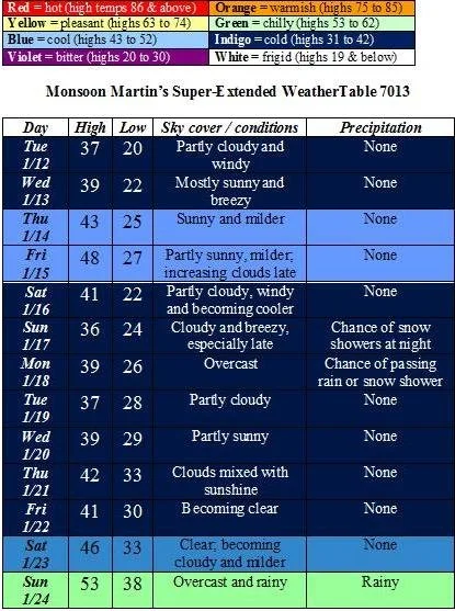
Weather narrative: Gradually milder throughout the week, with highs by Friday approaching 50. There’s a weather system that may impact the area on Sunday into Monday, but it’s looking very good that it will pass well to our south and give us just some flurries and snow showers. (I’ll send an update if my thinking changes on this system.)
Next week will feature temperatures about normal (highs in the 30s, lows in the 20s). The following weekend brings much milder temperatures and some rainy conditions.
Beyond the forecast: The last week of January will see a return to colder temperatures and the potential for more winter weather.
Stay tuned for updates!